Members and Supporters, the MountainViews Committee requests your help to meet the costs of the website and of other activities such as insured events or publications.
Feature count in area: 25, all in Kerry,
OSI/LPS Maps: 70, 71, 78, EW-DC, EW-DE, EW-DW
Highest Place: Beenoskee 826m
Starting Places (34) in area Central Dingle: Anascaul Village, Annascaul Lake, Ballyduff Grave Yard, Brandon Village, Cloghane Community Centre, Conor Pass, Doonore South, Doorah, Dromavally Mountain SE, Emlagh Cross, Emlagh Wood, Farrannakilla School, Glan Mountain, Glanteenassig Lane, Glanteenassig Wood CP, Glennahoo River, Hostel Cloghane Village, Killiney R560 Junction, Kilmore Lodge, Lios Pole Church, Lisduff Rath, Lough Camclaun, Lough Caum, Lough Doon CP, Lougher, Maum Cross, Maumnahaltora Cross, Minard Beach, Mullaghveal Farm, Owenascaul Estuary, Pedlars Lodge, Pilgrimage Trail Owenmore River, Sauce Creek Walkway Dingle Way, Teerbrin
Summits & other features in area Central Dingle: Cen: Annascaul Lake West: Cnoc na Bánóige 641.6m, Cnoc na Bánóige North Top 447.6m, Knockmulanane 593.2m, Knockmulanane West Top 563.5m Cen: Dromavally: Cummeen 477m, Dromavally Mountain 552m, Knocknakilton 423m N: Annascaul Lake North: Coombane 610m, Beenatoor 592m, Beenoskee 826m, Stradbally Mountain 798m N: Carrigdav: Carrigadav 240m N: Fermoyle: Farrandalouge 144m S: Annascaul: Beenmore 252m, Brickany 374m, Knockafeehane 301m, Knocknanacree 286m W: Ballyduff: Slievenalecka 458.4m, Beenbo 476.7m, Slievenagower 485.8m W: Slieveanea: An Cnapán Mór 649m, Knockmoylemore 493m, Croaghskearda 608m, Slievanea 628.7m, Slievanea NE Top 670.7m
Note: this list of places may include island features such as summits, but not
islands as such.
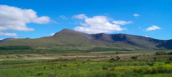
Slievanea, 628.7mMountain Sliabh Mhacha Ré A name in Irish,
Place Rating ..
(Ir. Sliabh Mhacha Ré [OSI], 'mountain of the smooth plain' ), Sliabh a' Fhia, Kerry County in Munster province, in Arderin Beg, Vandeleur-Lynam, Irish Best Hundred Lists, Sliabh Mhacha Ré is the 241st highest place in Ireland.
Grid Reference Q50748 05749,
OS 1:50k mapsheet 70 Place visited by: 165members, recently by: marymac, rhw, maoris, Tuigamala, SeanPurcell, NualaB, ToughSoles, Iamcan, derekfanning, Beti13, johncusack, Oscar-mckinney, Jai-mckinney, Carolyn105, farmerjoe
I visited this place: NO (You need to be a logged-in member for this.)
Longitude: -10.182926, Latitude: 52.183815, Easting: 50749, Northing: 105749,
Prominence: 22.4m, Isolation: 1km ITM: 450731 605803 Bedrock type: Cross-bedded sandstone, (Coumeenoole Sandstone Formation) Notes on name: The anglicised form Slievanea would appear to derive from Ir. Sliabh an Fhia, 'mountain of the deer'. The deer is also an important symbol in Celtic mythology. In many tales they lure people into the realm of the gods. Remains of several fulachta fia (venison-cooking pits) can be found around Lough Adoon.
Short or GPS IDs, 6 char: Slvn, 10 char: Slievanea Linkback: https://mountainviews.ie/summit/242/
Gallery for Slievanea (Sliabh Mhacha Ré) and surrounds
Summary
for Slievanea (Sliabh Mhacha Ré):
A high starting point
Summary created by scapania, jackill
2011-01-26 20:18:35
Picture: Slievanea from the way up Gearhane
Park in the large car park at the Connor pass.
Cross the main road and head due east uphill following a distinct track for 200 meters, leave this track as it swing sharply south and continue uphill and east, skirting cliffs to your left side.
These are steep cliffs, so keep some distance from them.
You will come to a small semicircle of stones at about 620 mtrs elevation , pick up a low stone wall and follow it to the unmarked summit about 400 meters to the east.
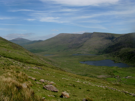
I had a few hours to spare while in Tralee last Friday so I headed for the Connor Pass with the intention of climbing Slievanea. The cloud was at about the 500 mtr mark and there was a strong wind blowing which kept the temperature at about 2 deg C, about 6 deg lower than in Tralee. There is a track leading up the mountain from the Connor pass but it seems to run around the side so I followed my GPS along the cliff edge. There is an indistinct track which you nearly have to follow by the soft feel of the ground compared to that on either side of it- someone has helpfully laid white stones at random intervals also but they are very far apart. About halfway up a sheep wire fence appeared at the edge of the cliff to my left. The top of Maughanablagher is marked by a semi circle of stones and the start of a stonewall which you can walk along some of the way towards Slievanea – 400 mtrs distant across flat ground. Slievaneas summit is a green, mossy area jutting out from the rough, brown grass that grows all along these cliffs. The cloud cover made it impossible to see anything so I beat a hasty retreat for the car. The picture is taken from the side of Maughanablagher at approx 500 mtrs, just below the cloud, looking across over the Pilgrims Route towards Gearhane and the Brandon mountains. Clogharee Lough is nearest, then Lough Atlea and in the distance the corner of Loch Cruite, the largest of Brandons Paternoster lakes. Linkback: mountainviews.ie/summit/242/comment/1453/
Read Less
Read More
Picture: The view to the west
jackill on Slievanea
by jackill
27 Oct 2005
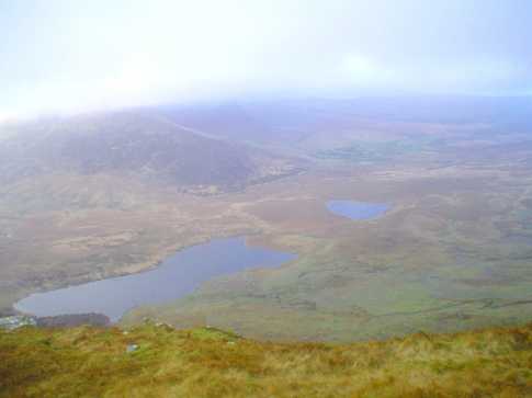
The view from near the summit of Slieveanea. Looking towards the Blaskets just in front of the low stone circle is An Cnoc Maol Mor (493 mtrs) Dingle(or An Daingean ?), Beenabrack, Ballysitteragh, the Mullaghaveal Gap , Fallaghnamara and the Brandon Ridge rising towards Gearhane in the clouds. The two lakes are An Loch Geal and Loch Ui Fhiannachta.This is a really beautiful and remote part of the country yet easily accessible from the Connor Pass. Linkback: mountainviews.ie/summit/242/comment/1973/
Read Less
Read More
padodes on Slievanea
by padodes
21 Jan 2008
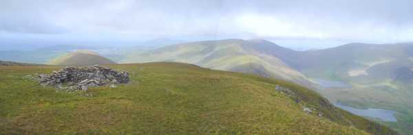
The best view of Slievanea is from the far side of the Owenmore River Valley, with your back to Brandon. When rising ground fog seems to lap at its flanks in the morning, it looks for all the world like a Titanic stuggling to make its way forward after taking a double whammy midship. The sharp prow is formed by Slievanea NE Top, and the two gaping corries behind are a stark reminder of its encounter with ice in the past. Further back, to the SW, the mountain tapers off to the Connor Pass (far right). The easiest access to the summit ridge, though not the most satisfying, is from the Pass, and the modest effort that is required to walk its length is repaid with wonderful views either westwards, over to the Brandon massif, or northeastwards, across to Beenoskee. If your are intent on peak-bagging, it's easy to take in An Cnapan Mor and Croaghskearda, all within easy range. Linkback: mountainviews.ie/summit/242/comment/2944/
Read Less
Read More
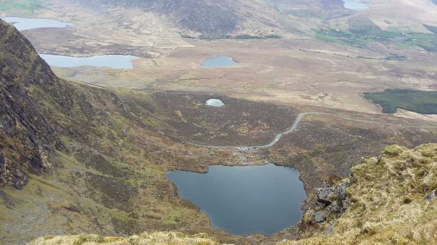
Picture: Pedlar's lake from Slievanea
Great views of Brandon and Lakes
by Bunsen7
18 Apr 2017
I came from the east across from Croaghskearda/Cnapan Mor. The route across is boggy but not difficult and mainly grassy bog.
You could incorporate Cnapan Mor into a loop from the Conor Pass Car Park or a more strenuous route from the north.
Use of MountainViews is governed by conditions and a privacy policy.
Read general information about the site. Opinions in material here are not necessarily endorsed by MountainViews.
Hillwalking is a risk sport. Information in comments, walks, shared GPS tracks or about starting places may
not be accurate for example as regards safety or access permission. You are responsible for your safety and your permission to walk.
See the credits and list definitions.


 Our Facebook page.