Members and Supporters, the MountainViews Committee requests your help to meet the costs of the website and of other activities such as insured events or publications.
Feature count in area: 18, by county: Dublin: 16, Wicklow: 7, Kildare: 1, of which 6 are in both Dublin and Wicklow,
OSI/LPS Maps: 43, 50, 56, AWW, EW-DM, EW-WE, EW-WW
Highest Place: Kippure 757m
Starting Places (77) in area Dublin: Allagour Road, Ballinascorney Golf Club, Ballylerane, Ballylow Bridge, Ballyreagh Wood, Ballyross Forest, Ballysmuttan Long Stone, Barnaslingan Wood, Bohernabreena North CP, Boranaraltry Bridge, Bray Harbour, Cabinteely House, Cannon's Corner, Carrickgollgan, Castelkelly Bridge, Clonkeen Road South, Cloon Wood Cp, Cransillagh Brook , Crone Wood CP, Cruagh Forest Recreation Area, Cruagh Road Hairpin, Curtlestown Wood CP, Dunnes Bank, Enniskerry, Fernhill Estate, Gap Road, Garadhu Road, Glencree Reconciliation, Hell Fire Wood CP, Johnnie Fox Pub, Kilbride Army Camp Entrance, Kilgobbin Lane, Killakee Car Park, Killiney Hill Carpark, Kilmashoge Forest CP, Kilsaran Quarry, Kippure Bridge, Kippure Estate, Kippure Transmitter Gate, Knockbrack, Knockree west, Lackan Wood S, Lamb Doyles, Laughanstown Luas, Lee's Lane, Liffey Bridge, Liffey Head Bridge, Lough Bray Lower, Lough Bray Upper, Lynch's Park Road, Marley Park CP, Novara Avenue, Bray, Old Wicklow Way entrance, Pavilion Theatre, Pine Forest Road, Putland Road, Raheenoon, Rathmichael RC Church, Rathmichael Wood CP, Sally Gap, Sally Gap N, Seahan 265', Seahan 300', Sean Walsh Park, Seefin Trailhead, Shankill Byrnes Bar, Shankill Tributary Bridge, Slademore Road, Sraghoe Brook, St Catherine's Park, The Lamb Hill, The Scalp, Tibradden Forest Recreation Area, Tibradden Lane, Ticknock Forest, Vance's Lane, Wyattville Close
Summits & other features in area Dublin: N: Howth: Ben of Howth 171m N: Naul: Knockbrack 176m S: Dublin South East: Carrickgollogan 275.2m, Glendoo Mountain 585.1m, Killiney Hill 153.5m, Knocknagun 555.3m, Montpelier Hill 383m, Prince William's Seat 553.5m, Tibradden Mountain 466.2m, Two Rock Mountain 536m S: Kippure & Kilbride: Corrig Mountain 617.1m, Kippure 757m, Seahan 647.3m, Seefin 620.6m, Seefingan 722.9m S: Saggart: Cupidstown Hill 378.6m, Knockannavea 400.8m, Saggart Hill 396.9m
Note: this list of places may include island features such as summits, but not
islands as such.
Seefin, 620.6mMountain Suí Finn A name in Irish,
Place Rating ..
(Ir. Suí Finn [PNCW*], 'Fionn’s seat'), Seefing, Shangil Chapel, Wicklow County in Leinster province, in Arderin Beg, Vandeleur-Lynam Lists, Seefin is the 254th highest place in Ireland. Seefin is the second most southerly summit in the Dublin area.
Grid Reference O07397 16251,
OS 1:50k mapsheet 56 Place visited by: 651members, recently by: rhw, Courin, KateLeckie, Padraigin, taramatthews, davidrenshaw, Prem, Magic, Carolineswalsh, Nailer1967, Tommer504, Tuigamala, NualaB, abacusms, McWobbley
I visited this place: NO (You need to be a logged-in member for this.)
Longitude: -6.394181, Latitude: 53.186149, Easting: 307397, Northing: 216251,
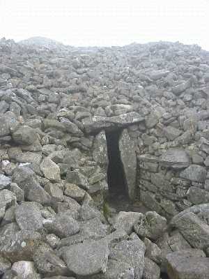
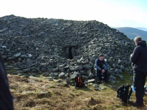
Prominence: 22.3m, Isolation: 1.5km ITM: 707322 716281 Bedrock type: Pale grey fine to coarse-grained granite, (Type 2e equigranular) Notes on name: There is an impressive megalithic cairn on Seefin. It is still possible to enter it, although the roof has collapsed at the centre.
Short or GPS IDs, 6 char: See621, 10 char: Seefin 621 Linkback: https://mountainviews.ie/summit/241/
Gallery for Seefin (Suí Finn) and surrounds
Summary
for Seefin (Suí Finn):
Great views with megalithic history.
Summary created by Peter Walker, simon3
2015-03-16 19:50:26
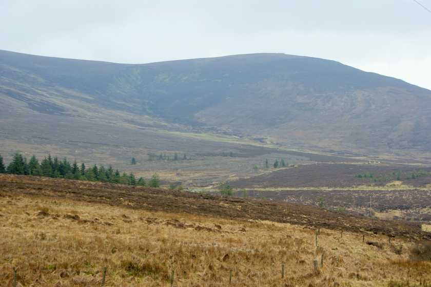
Picture: Seefin from the NW
Seefin has many attractions for the walker, giving great views over west Wicklow, the Pollaphuca Reservoir and Kildare. It also has a magnificent megalithic tomb parts of which it is still possible to clamber into.
There's a number of ways of reaching the top. One place to start from is Shankill Bge (O0636 1747). Walk from there to around Seefin Tr (O0629 1685) and then head up the hill keeping outside the boundary fence of the Kilbride Firing Range. The advantage of this starting point is that should you be doing a circuit coming back via Seahan, you are positioned fairly far north.
Alternatively you can start from various places such as A (O068 154) (up a ride) or the car park at Kippure Bridge KipureBrg (O079 145). It will take about 30 mins to reach the top.
Incidentally this summit with its cairn is with its neighbour Seefingan very visible on the approaches to Dublin on the M7/ N7.
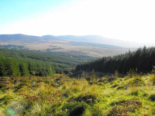
Picture: Views to Mullaghcleevaun and Coronation Plantation from Athdown Brook.
Homerclesse on Seefin
by Homerclesse
28 Mar 2010
I have tackled this summit a number of times from a couple of approaches. My favourite is to park at the gates of the Kippure Estate and follow the track across the road. This eventually leads into heavy forest with a lot of deeply rutted tracks and felled trees. The best option is to head to the river bank (Athdown Brook) and climb up along the left side bank of it. A nice view behind you to the Coronation Plantation and the Mullaghcleevaun Range. Once you clear the line of trees on the left then it's simply a matter of heading a little north of west to the summit Seefin. A very interesting Cairn awaits and will be your heading in clear weather. Great views of the Blessington Lakes, the other hills of the West Wicklow range, south to Mullaghcleevaun and east to Kippure and Sugar Loaf.
An alternative route is to park on the west side of Seefin at the gates and go straight up the Forest track.
Seefin can be incorporated into a nice ridge walk to Seefingan and Kippure or to Seechon and Corrig and Back to Seefin. Linkback: mountainviews.ie/summit/241/comment/4545/
Read Less
Read More
padodes on Seefin
by padodes
3 Nov 2008
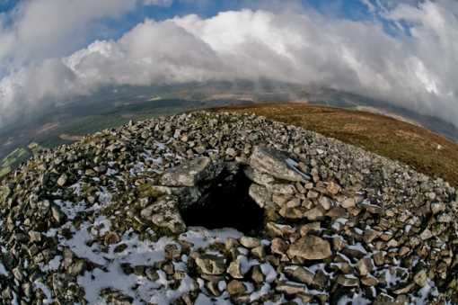
If you like combining a walk in the hills with a stroll through history, then Seefin provides plenty of interest. The easiest approach is from a point south of the entrance to the army rifle range at Kilbride. Starting at A (O068 154) (limited parking), a 250m climb takes you straight up a forest ride (not shown on the OSI map) to the 621m summit and to one of the finest surviving prehistoric sites in Wicklow: the passage tomb at B (O0735 1626).
The huge cairn on top – a full 24m across and 3m high – is already quite impressive, but as you circle around to the north, the exposed entrance, with its massive lintel and posts, gives the first real taste of what lies within. From here, a 7m long passage extends back into the corbelled central chamber, now open to the sky since the capstones were removed. The recent photo I took gives a fisheye view of the (snow-ribbed) top of the cairn, looking into the chamber below. In the chamber itself, accessed either by squeezing through the passage or by letting oneself down through the open top, there are five alcoves, some of which are now partly obstructed by rock-fall. They would probably have held human remains, but when the tomb was excavated in 1931/32, it appears that no vestiges of burial or other artefacts were found. That is hardly surprising, however, when one considers that the tomb has been open for the best part of two millennia. The etching, on one of the roof-stones, of a Greek (equal-armed) cross, thought to be of early Christian origin, would seem to prove that. Linkback: mountainviews.ie/summit/241/comment/3420/
Read Less
Read More
csd on Seefin
by csd
13 Apr 2003
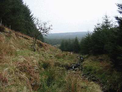
The easiest way to approach Seefin is from the car park at Kippure Bridge. Follow the forest track up, but rather than marching all the way to the top using this track, veer right just before the track dips into a ford and follow the Athdown Brook up (see picture). This is a pleasant detour which will bring you up onto the Seefin - Seefingan track. If you want to come back down via the forest tracks, note that the Harvey map is not 100% accurate - there appears to be at least one extra SW-NE track not marked on the map, north of the two that are marked. Linkback: mountainviews.ie/summit/241/comment/435/
Read Less
Read More
csd on Seefin
by csd
13 Apr 2003
The entrance to the megalithic tomb at the summit of Seefin. Unfortunately the roof of the cairn has collapsed. Linkback: mountainviews.ie/summit/241/comment/436/
Read Less
Read More
Picture: Seefin's Tomb
murphysw on Seefin
by murphysw
17 Feb 2008
A handy way to get onto Seefin if the red flags are out for army firing practice is to park up at the boulder lined layby at about C (O064 166). The firebreak here will cut straight through the forest and bring you onto the mountainside. The previous week I had gone up Seefin only and had taken the wrong firebreak which ended in a cul de sac. No worries, just scoot through the forest to the correct one. Once out of the forest follow the fencing until it swings away to the south. It doesn't present an obstacle as its badly torn up there. Then, its a straightforward slog to the summit and its tomb, which is the best of the circuit, though unaccessable to the less than thin! Linkback: mountainviews.ie/summit/241/comment/2965/
Use of MountainViews is governed by conditions and a privacy policy.
Read general information about the site. Opinions in material here are not necessarily endorsed by MountainViews.
Hillwalking is a risk sport. Information in comments, walks, shared GPS tracks or about starting places may
not be accurate for example as regards safety or access permission. You are responsible for your safety and your permission to walk.
See the credits and list definitions.


 Our Facebook page.