Members and Supporters, the MountainViews Committee requests your help to meet the costs of the website and of other activities such as insured events or publications.
Feature count in area: 57, by county: Cork: 32, Kerry: 36, of which 11 are in both Cork and Kerry,
OSI/LPS Maps: 83, 84, 85, 88
Highest Place: Hungry Hill 682m
Starting Places (51) in area Caha Mountains: Ardgroom, Barley Lake North, Bere Island Pier, Caha Pass, Canshanavoe South, Carriganine, Cashelkeelty Stone Circles Carpark, Castletownbere Lifeboat Harbour, Clashduff River Farm, Coolieragh Harbour Road, Coomadayallig Lake Road N, Coomadayallig Lake Road S, Cooryeen Lane, Cummer Lough East Road, Derreenataggart Stone Circle Road, Dromoghty Lough North, Dunboy Wood, Esk Boreen, Eyeries, Fehanah Lane, Garinish Island Pier, Glantrasna Bridge, Glenbeg Lough N, Glengarriff, Glengarriff Nature Reserve CP, Gleninchaquin Waterfall, Gowlaun Lough, Healy Pass, Healy Pass Hairpin, Ilnacullin Car Park, Kenmare Bridge, Knockacullin Lane, Leahill Bog, Leitrim Beg Standing Stone, Lough Inchiquin SE, Magannagan Stream, Molly Gallivan's Visitor Centre, Nora's Cottage, Old Lansdowne School, Owgarriff River Lane, Peg's Shop, Pooleen Wood Car Park, Red Trout Lake, Reenroe Bridge, River Drimminboy Track, Rossmackowen Bridge, Rossmackowen Cemetery, Shronebirrane Farm, Shronebirrane Road, Toberbanaha, Turner's Rock Tunnel
Summits & other features in area Caha Mountains: Cen: Hungry Hill: Coombane 510m, Derryclancy 554m, Hungry Hill 682m Cen: Knockowen: Cushnaficulla 594m, Glenkeel Top 417m, Knockastumpa 398m, Knockeirky 577m, Knockeirky South Top 523m, Knockowen 658m, Stookeennalackareha 412m E: Glengarriff: Derrynafulla SW 375m, Gowlbeg Mountain 362m, Nareera 530m, Nareera North Top 503m, Nareera South-West Top 505m, Shrone Hill 283m, Sugarloaf Mountain 574m, Sugarloaf Mountain Far West Top 560m, Sugarloaf Mountain West Top 565m N: Coomnadiha: Baurearagh Mountain 489m, Caha Far SE Top 555m, Caha SE Top 585m, Coomnadiha 644m, Coomnalack Top 435m, Cummeenbaun 510m, Droppa 522m, Killane Mountain 537m, Killane Mountain South-West Top 533m, Knockagarrane 414m, Knockreagh 500m N: Knockeirka: Barraduff Mountain 400m, Killaha Mountain 400m, Knockeirka 426m N: Knocknagorraveela: Derrysallagh 410m, Feorus East 474m, Knocknagorraveela 507m, Knocknagorraveela NE Top 464m N: Lauragh: Knockanoughanish 386m, Knockatee 330m S: Castletownbere: Disert 205m, Knockanallig (Bear Island) 267m W: Ardgroom: Derryvour Hill 160m W: Eskatarriff: Coomacloghane 599m, Eskatarriff 600.5m, Eskatarriff East Top 532.7m, Knocknaveacal North Top 509.1m, Knocknaveacal South Top 507.2m, Lackabane 603m, Tooreenbaha 408.7m, Tooreennamna 524m, Tooth Mountain 592m W: Knocknagree: Knocknagree 586m, Knocknagree East Top 461m, Knocknagree SE Top 442m, Lackawee 572m, Maulin 621m, Maulin North Top 579m
Note: this list of places may include island features such as summits, but not
islands as such.
Maulin, 621mMountain Málainn A name in Irish,
Place Rating ..
(Ir. Málainn, meaning obscure), Cork County in Munster province, in Arderin, Vandeleur-Lynam Lists, Maulin is the 253rd highest place in Ireland.
Grid Reference V71290 50530,
OS 1:50k mapsheet 84 Place visited by: 121members, recently by: rhw, Lidia27, Shaina, ToughSoles, hannahlk, Ainegavgav, Beti13, Krzysztof_K, CusackMargaret, Naoisealexandra, just.explores, markv, Ianhhill, johncusack, a3642278
I visited this place: NO (You need to be a logged-in member for this.)
Longitude: -9.862125, Latitude: 51.692997, Easting: 71290, Northing: 50530,
Prominence: 226m, Isolation: 0.7km ITM: 471268 550597 Bedrock type: Purple & green sandstone & siltstone, (Caha Mountain Formation) Notes on name: Misspelt Málaínn on Discovery map.
Short or GPS IDs, 6 char: Maulin, 10 char: Maulin Linkback: https://mountainviews.ie/summit/240/
Gallery for Maulin (Málainn) and surrounds
Summary
for Maulin (Málainn):
Flattish top with views to bays north and south.
Summary created by simon3, jackill
2012-10-30 15:34:57
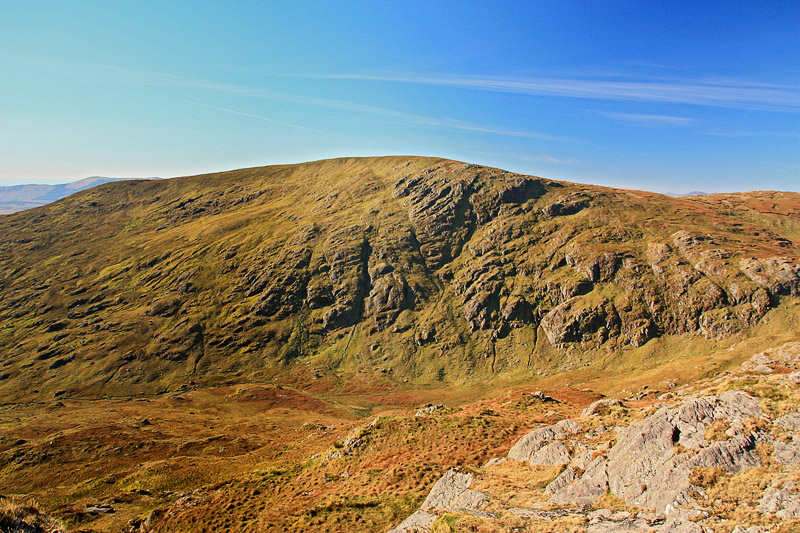
Picture: Maulin as viewed from the East.
Leave the car at Rosmackowen Church Ross Cem (V74200 47209) and head up the little borheen immediately after the Church on the Castletownbere side.
Take the left hand fork after a few hundred meters and continue on through a gate following a rough track to the Glas Loughs at about 400 meters elevation.
The face of Knocknagree that looks out over Beara Island is the best approach to take with the least amount of climbing around the rocky folds typical of the area.
Down the rough far side then to a small lake and a climb where the ground gets gradually more rounded to the summit area
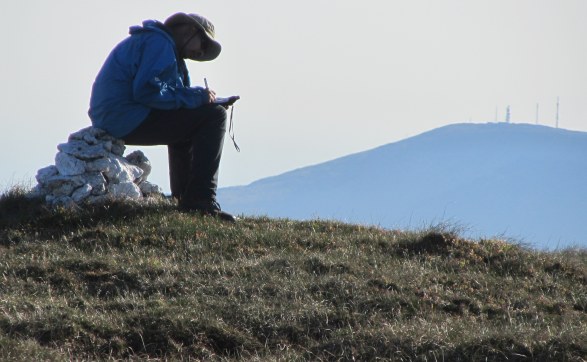
Picture: A Hendroff taking a break to write his memoirs
Just a stone's throw from Hungry Hill. Or a short drive.
by dbloke
25 May 2010
The summit cairn on Maulin has grown a bit since Jackill's visit five years ago. Either that or he's been lying for years about how big six inches is! Most of the bog has been baked dry in all the hot weather we've been having, although there is a large muddy area away from the summit that looks like it's been part of a cattle stampede. The gentle SW slope makes for a quick, easy descent down to the track and the Beara Way. Linkback: mountainviews.ie/summit/240/comment/5826/
Read Less
Read More
Accessing the hills at Castletownbere via the Beara Way
by three5four0
16 Aug 2010
Climbed Maulin via the Beara way, we parked in the car park by the pier in Castletownbere and followed the Beara Way out of town. Where the Beara Way turns left at A (V685 465), keep straight on till B (V70411 46740), where the road turns left and climbs up hill. Follow this road, which turns into a track, up hill rejoining the Beara Way at Derrymihin East. At the apex of the spur leave the Beara way, by one of the three tracks marked on the map, and strike up hill over easy ground, towards pt 558. Once reached, its a further 3/4 km over a much easier gradient to the summit of Maulin, with its small white cairn.
The views are good, particularly towards Knocknagree and the rough ground of Hungry Hill. We continued onto traversing the minor top at pt 579 on our way to Lackawee. Linkback: mountainviews.ie/summit/240/comment/6023/
Read Less
Read More
Gruesome murders and royal graves...
by Conor74
19 Dec 2011
...the gruesome tale is recounted by Richard Mersey in his "The Hills of Cork and Kerry", who mentions a visit of John Puxley (the owner of the copper mines that employed so many in Beara) to the summit of Maulin. He thought he saw a cairn at the top until he got closer and realised it was the body of a "middleman" who had been murdered and displayed like a scarecrow, and whose eyes had been plucked out by crows. Sadly I can't find any more on this wonderfully gruesome tale online, nor is it clear to me what he means by "middleman" - I will see if the local libraries can shed any more light. The summit is now marked by one of the more attractive cairns, small but built with blocks of marble. I guess the mountains on this the Cork side of the border have a gruesome tale to match the story of the Rabach and his cave in the "Pocket" in Kerry, to the east.
The area is also the site of a famous grave. Owen Mór, King of Ireland in circa 120 AD had fought a battle on the peninsula and after he was nursed back to health he sailed for Spain. There he met and married the Beara, daughter of the King of Castille in Spain. He returned to the area with her, and a large army, and took her to Bear Island where he named the whole peninsula after her. She was buried in Ballard Commons, the large valley that separates Maulin and Knocknagree.
After resting at the small lake on the col after Knocknagree I headed for Maulin.
In contrast to Knocknagree , Maulin is covered in short heather with on the occasional bit of rock jutting out . The climb to the summit is initially a bit steep but levels off to a more gradual slope.
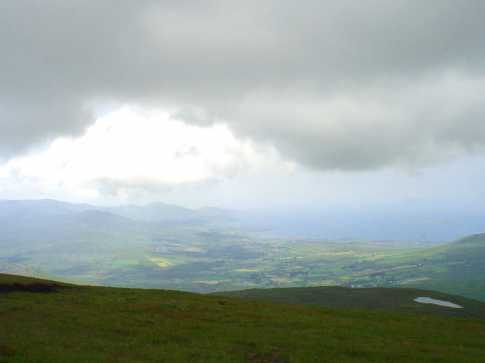
The summit is marked by a small pile of stones only about 6 inches high which could be easily missed, and is covered in a short, rough grass. The going underfoot is generally quite good with a few very wet areas which definately are to be avoided. After a short break to admire the views it was on to Lackawee. The photo was taken from the summit and looks out over Eyeries and Coulagh Bay. On the left are the lesser summits of the Slieve Mickish range , Mickish Mountain, Knockoura and Knockgour. Linkback: mountainviews.ie/summit/240/comment/1790/
Read Less
Read More
Bleck Cra on Maulin
by Bleck Cra
18 Aug 2004
Evelyn, reference your recent comment vis-a-vis rubbish on the hill, the Mournes as you may know, is starting to look like the hood in Rio. Next time you see rubbish (and I mean the perpetrator/s), why not put THEM in your bin, They'll smell a bit , but sure don't they anyway ?
Good natured banter apart, this is becoming a serious problem. Any ideas ? Linkback: mountainviews.ie/summit/240/comment/1097/
Use of MountainViews is governed by conditions and a privacy policy.
Read general information about the site. Opinions in material here are not necessarily endorsed by MountainViews.
Hillwalking is a risk sport. Information in comments, walks, shared GPS tracks or about starting places may
not be accurate for example as regards safety or access permission. You are responsible for your safety and your permission to walk.
See the credits and list definitions.


 Our Facebook page.