Donation Request 2024

DONATE
Members and Supporters, the MountainViews Committee requests your help to meet the costs of the website and of other activities such as insured events or publications.
You do not have to be logged in to donate.
Features
Nearby features appear when you click the map.
Declutter tracks on map.
Place Search
Video
X
Pub: by
Mourne Mountains Area , W: Slievemoughanmore Subarea
Feature count in area: 58, all in Down, OSI/LPS Maps: 20, 29, EW-CLY
Highest Place: Slieve Donard 849m

Starting Places (33) in area Mourne Mountains:
Alex Steddom Tree, Aughrim Airstrip, Ben Crom Dam, Bloody Bridge Car Park, Carlingford Greenway, Carrick Little, Crocknafeola Wood, Crotlieve Mountain, Donard Car Park Newcastle, Drummanmore Picnic, Fofanny Reservoir, Forest Office CP, Gamekeepers Lodge CP, Happy Valley Trassey Rd, Hen Mountain CP, Leitrim Lodge CP, Mayo Road Corner, Meelmore Lodge, Newcastle Harbour, Ott CP, Red Bog Road, Rourkes Park, Sandy Brae, Silent Valley Reservoir Head Rd, Slieve Donard Trail Head, Slieve Foye Viewing Point, Slievefoy Forest CP, Spelga Dam E, Spelga Dam N, Spelga Dam S, Trassey Car Park, Two Mile River CP, Yellow Water Park

Summits & other features in area Mourne Mountains:
Cen: Loughshannagh: Ben Crom 526m, Carn Mountain 585.2m, Carn Mountain North Top 553.7m, Doan 592.6m, Ott Mountain 526.8m, Slieve Loughshannagh 617m, Slieve Muck 670.4m, Slievenaglogh 445m
E: Binnian: Slieve Binnian 745.9m, Slieve Binnian East Top 639m, Slieve Binnian North Top 678m, Slieve Binnian North Tor 682.5m, Wee Binnian 460m
E: Donard: Chimney Rock Mountain 656m, Crossone 540m, Millstone Mountain 460m, Rocky Mountain 524m, Slieve Donard 849m
E: Lamagan: Cove Mountain 654.8m, Slieve Beg 595.9m, Slievelamagan 702.2m
N: Bearnagh: Slieve Bearnagh 739m, Slieve Bearnagh North Tor 680m, Slieve Meelbeg 701.9m, Slieve Meelmore 687m
N: Castlewellan: Slievenalargy 280m, Slievenaslat 272m
N: Commedagh: Slieve Commedagh 767m, Slieve Corragh 641.9m, Slievenaglogh 584.4m, Slievenaglogh East Top 571m
N: Croob: Cratlieve 429m, Slieve Croob 534m, Slievegarran 391m, Slievenisky 446m
N: Rathfriland: Knockiveagh 235m
S: Kilkeel: Knockchree 306m
S: Rostrevor: Crenville 460m, Finlieve 578m, Slievemartin 485m, Slievemeel 420m, Slievemeen 472m
W: Hilltown: Gruggandoo 382m, Slieveacarnane 296m
W: Slievemoughanmore: Crotlieve Mountain 347m, Eagle Mountain 638m, Rocky Mountain 404m, Shanlieve 626m, Slievemoughanmore 560m, Tievedockaragh 473m, Wee Slievemoughan 428m
W: Spelga: Butter Mountain 500m, Cock Mountain 504m, Cock Mountain South-West Top 505m, Hen Mountain 354m, Pigeon Rock Mountain 534m, Pigeon Rock Mountain South Top 530m, Slievenamiskan 444m

Note: this list of places may include island features such as summits, but not islands as such.
Rating graphic.
Shanlieve, 626m Mountain Seanshliabh A name in Irish,
Place Rating ..
(Ir. Seanshliabh [PNNI], 'old mountain'), Down County in Ulster province, in Arderin, Vandeleur-Lynam Lists, Shanlieve is the 248th highest place in Ireland.
Grid Reference J24068 22669, OS 1:50k mapsheet 29
Place visited by: 340 members, recently by: trostanite, rhw, davidrenshaw, Prem, Carolineswalsh, Dee68, ElaineM76, Beti13, ToughSoles, muddypaws, Lyner, Alanjm, Paddym99, Krzysztof_K, Sarahjb
I visited this place: NO (You need to be a logged-in member for this.)
Longitude: -6.10237, Latitude: 54.138092, Easting: 324068, Northing: 322669, Prominence: 31m,  Isolation: 0.5km
ITM: 723996 822672
Bedrock type: Granite granophyre, (Mourne Mountains granite)
Notes on name: What is meant by 'old mountain'?, one may ask. Names of this type usually refer to the fact that a place was cleared for agricultural exploitation at an early date and acquired their name when activity shifted to a new area.
  Short or GPS IDs, 6 char: Shnlv, 10 char: Shanlieve

Linkback: https://mountainviews.ie/summit/236/
Gallery for Shanlieve (Seanshliabh) and surrounds
Summary for Shanlieve (Seanshliabh): The most westerly 600m top in the Mournes
Summary created by Harry Goodman 2011-11-23 16:59:37
            MountainViews.ie picture about Shanlieve (<em>Seanshliabh</em>)
Picture: Looking S to Finlieve from Shanlieve summit.
Route 1: Start Leitrim Lodge car park A (J224 257). Follow the track SE up to the Castle Bog B (J230 238). Follow one of the tracks S through the bog to Bratts Wall C (J230 231), turn left (SE) and follow it along. A break in the wall occurs near tiny Shanlough (a deep boggy area) where it is replaced by a wire fence, before re-appearing further along. It is advisable, whatever the underfoot conditions, to seek out firmer ground to the N or S of Shanlough and not try to go along the fence line. Once around Shanlough come back to the wall for the steep climb up to Shanlieve. As the summit lies to the right and to the S of the wall keep it on the left on the way up. Where the wall levels out and turns NE D (J24050 22700), walk S a short distance to the summit cairn. Route 2: Start from Attical Community Centre car park E (J268 189). Go NE and turn left into Sandy Brae. After 2k cross a footbridge SndyBr (J263 206) and then go left along a stone wall to a stile. Head NW up a long spur to pick up a track F (J25253 21673) and then up to G (J246 223). The summit lies 700m along NW up the slope.
A climb of Shanlieve is normally included in a circuit that will also include Eagle Mt., given it's close proximity. It is also a good point to access the long, broad, flat ridge S to Finlieve, not a MV listed top but well worth a visit.
Linkback: mountainviews.ie/summit/236/comment/4996/
Member Comments for Shanlieve (Seanshliabh)
Comment create / edit display placeholder

Western Mournes Hike
by hbowman1 22 Apr 2012
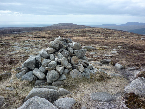
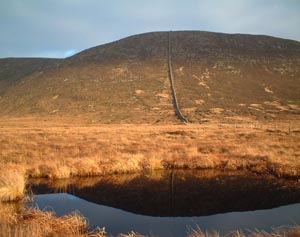
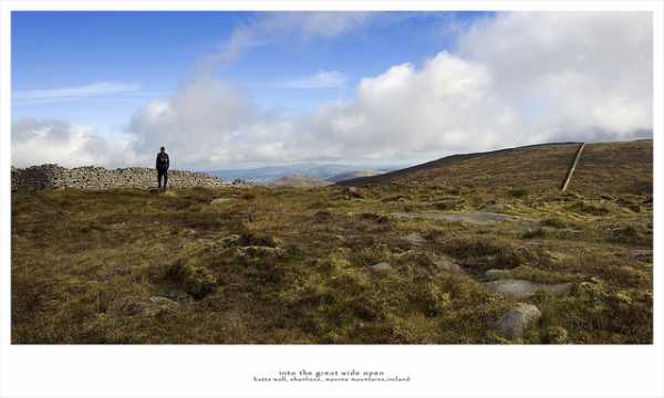
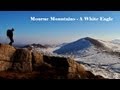
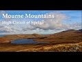
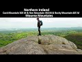
I think Shanlieve is best climbed as part of a circuit of a longer walk rather than in isolation. Due to its close proximity of Eagle mountain and given the fact that Eagle mountain is taller, spectacular views would be missed if one stopped at Shanlieve. I recently climbed this mountain as part of a circuit which took in Shanlieve, Eagle, Slievemoughanmore, wee Slievemoughan and Rocky mountain. Starting from Leitrim Lodge, we followed the path which ran from the car park towards Pierce's Castle. To the right of the path lay Altataggart and Tievedockaragh and to the left of the path lay Rocky mountain, Tornamrock and Pierce's Castle. Unfortunately, this path does come to an end after Pierce's Castle. Thereafter, there is marshy pathless terrain to cover as we headed toward the Mourne wall, leading up to Shanlieve. This is the first steep ascent of the walk. However, upon summiting Shanlieve, nice views were to had of the Binnians and Slievenaglogh. Turning left, we followed the wall towards Eagle mountain. For me, the best part of hillwalking is the point when an extensive panoranma opens up very suddenly, when all one sees beforehand is the mountain which is being climbed. Arguably, Eagle mountain, is the best mountain in the Mournes in this respect. Extensive views are to had in every direction: Turning clockwise: Hen, Cock, Slievemoughanmore, Butter, Slieve Muck, Bernagh, Commedagh, Donard, Binnain, Slievenalogh, Finlieve, Shanlieve, Slieve Foye/Gullion in the Cooleys. We followed the wall from Eagle to the Windy Gap and thereafter climbed Slievemoughanmore. I would strongly recommend turning away from the wall as one draws near the summit. The summit cairn is a reached by turning left from the wall when the plateau flattens after the ascent from Windy Gap. The summit cairn offers decent views of the Spelga Dam and the valley between Cock/Hen and Rocky/Tornamrock. We descended towards wee Slievemoughan. This is probably, the smallest mountain in the Mournes. After summiting we headed towards the valley between Rocky mountain (opposite Hen) and Tornamrock. At this point, it is possible to return to Leitrim Lodge or, alternatively, take in Rocky. The main reason to take in Rocky mountain is simply this: you can admire all the mountains which you have just climbed: Shanlieve, Eagle, Slievemoughanmore, wee Slievemoughan. The full circuit is just over 11km. Linkback: mountainviews.ie/summit/236/comment/6785/
Read Less
Read More

            MountainViews.ie picture about Shanlieve (<em>Seanshliabh</em>)
Picture: I had a picture but the Pixies stole it ... er.
Bleck Cra on Shanlieve
by Bleck Cra 5 Jan 2006
The western Mournes hang grim, grey and glowering over the most beautiful Irish countryside this side of a Killarney postcard. The latter roams green, gold and free, as its inhabitants, in pretty foothill towns like Hilltown and Kilcoo. Politics hasn’t much changed here in a millennium: the invaders - English, Norman French, Welsh and other blow-in adventurers basked on the balmy coast while the indigenous chieftains paced restlessly in the boggy interior. Between them and guarding the gate …., these wily townlands and villages. These are Mournes but not as we know them Jim. They are trackless, endless, sometimes pointless and can make the River Amazon seem dry. But they have an appeal: and that is strangeness. Hen rises, a raggle of tors barely knee-high to her neighbours, but like an irritating tomboy threatens grevious mischief from crags, tops, gullies and dizzy drops. Boggy Cock Mountain would drain hope from the Pilgrim Fathers. Pigeon Rock, a soggy ankle-snapper, confuddles us with 2 tops. Batts wall, not in the muscular style of the Mourne one, but more believeable, tracks a route up to Slievemoughanmore, to Eagle, then to the summit of the experience, Shanlieve - at the centre of the horseshoe and placed to squint at her more feted eastern cousins - and so ever downwards to what’s left of Shan Lough. To the conservationist, this marks the loss of another Mournes lough and to the average walker, the wettest spot on the planet. This strangeness is punctuated by mirages like Pierce’s Castle, the bizarre desert-bog-desert at its foot, the Great Gully off Eagle Mountain - black and spoooooky and the oddest of ancient(?) man-made formations at the turn of the river under Rocky. Would you love them if you reared them? Probably not a lot - but probably. Linkback: mountainviews.ie/summit/236/comment/2121/
Read Less
Read More

            MountainViews.ie picture about Shanlieve (<em>Seanshliabh</em>)
gerrym on Shanlieve
by gerrym 14 Feb 2004
I started at Yellow River picnic area (grid YelWtPk (J209 223)) and followed path upstream crossing 2 bridges onto a forest road. Follow this uphill and along valley side through Rostrevor Forest until reach Batts Wall (grid H (J218 237)). Cross wall and take rough track to a religious monument celebrating Pope John Pauls visit to Ireland - complete with large cross and alter table! Continue uphill along Batts Wall which goes direct to the summit - gaiters are a necessity. From the summit there are good views to Binnian and into the Silent Valley to Ben Crom, continued over 2km south staying above 550m to reach Finlieve for views over Carlinford Lough. Had cloud cover and heavy mist most of day but sun came out as i was returning so got some nice pics - Shanlieve reflected in Shanlough included here. Linkback: mountainviews.ie/summit/236/comment/846/
Read Less
Read More

three5four0 on Shanlieve
by three5four0 20 Jul 2008
After Eagle Mtn it is a short walk to Shanlieve & an ideal stop for my lunch on my hike to Rostrevor.

Descending S, then SSW towards point 583 before turning west for pt 476 and SW again to pt 432,
with a fence to negotiate on the way to Slievemeel. The best thing is to leave this slopes well alone,
particularly after rain. Perhaps better tackled after about 4 foot of snowfall in snowshoes or skis. Linkback: mountainviews.ie/summit/236/comment/3238/
Read Less
Read More

            MountainViews.ie picture about Shanlieve (<em>Seanshliabh</em>)
Picture: Following the wall back to Eagle
Two for the price of one!
by paulocon 25 Aug 2010
From Eagle, it's just a short stroll along Batts Wall across to the summit cairn on Shanlieve - a case of two 600 metre summits for the price of one!. The cairn stands just a short distance from the wall and on our visit, was surrounded by a white covering of Bog Cotton. Pigeon Rock, Slievemoughanmore, Eagle and Shanlieve make up a nice walk from Deers Meadow, the only drawback being that you have to retrace your steps back to the starting point although the more adventurous can plot a return route off the beaten track. Linkback: mountainviews.ie/summit/236/comment/6056/
Read Less
Read More
EDIT Point of Interest
text
Videos


Recent Contributions
x
Conditions and Info
Use of MountainViews is governed by conditions and a privacy policy.
Read general information about the site.
Opinions in material here are not necessarily endorsed by MountainViews.
Hillwalking is a risk sport. Information in comments, walks, shared GPS tracks or about starting places may not be accurate for example as regards safety or access permission. You are responsible for your safety and your permission to walk.
See the credits and list definitions.

OSi logo
OSNI/LPS logo
Open Street Map
(Various variations used.)
British summit data courtesy:
Database of British & Irish Hills