Donation Request 2024

DONATE
Members and Supporters, the MountainViews Committee requests your help to meet the costs of the website and of other activities such as insured events or publications.
You do not have to be logged in to donate.
Features
Nearby features appear when you click the map.
Declutter tracks on map.
Place Search
Video
X
Pub: by
Nephin Begs Area , Cen: Nephin Beg Subarea
Feature count in area: 28, all in Mayo, OSI/LPS Maps: 22, 23, 30, 31, CBW, EW-ACC, EW-WNN, EW-WNS
Highest Place: Slieve Carr 721m

Starting Places (24) in area Nephin Begs:
Altnabrocky Adirondack Shelter, Bellanaderg Bridge, Brogan Carroll Bothy, Bunnahowna Bridge, Bunnahowna River, Burrishoole Loop, Cloondaff Church, Deel River, Furnace Lough E, Glasheens River, Glendahurk Bridge, Glennamong Bridge, LFeeagh E Treenbeg Cottage, LFeeagh E Treenbeg School Ruin, Lough Avoher Hut, Lough Feeagh, Lough Gall NW Mayo, Loughanawillan Loughs Track, Mulranny Post Office, R312 Boghadoon, R312 Prughlish, Srahduggaun, Tarsaghaunmore River, Wild Nephin Wilderness

Summits & other features in area Nephin Begs:
Cen: Glennamong: Bengorm 582m, Bengorm NW Top 468m, Corranabinnia 716m, Corranabinnia SW Top 687m, Glennamong 628m, Glennamong East Top 415m, Tirkslieve 401m
Cen: Nephin Beg: Aroher Hill 285m, Lettertrask 279m, Nephin Beg 627m, Nephin Beg South Top 410m
E: Birreencorragh: Birreencorragh 698m, Birreencorragh South Top 564m, Birreencorragh West Top 551m, Buckoogh 588m, Bullaunmore 388m, Knockaffertagh 517m, Mount Eagle 427m, Srahmore 186m, Srahrevagh North 282m
NW: Slieve Carr: Bunmore 243m, Sheeanmore 282m, Slieve Alp 329m, Slieve Carr 721m, Tawnyanruddia 531m
SW: Maunthomas: Claggan Mountain NE Top 501m, Maumthomas NE Top 440m, Maumthomas SW Top 477m

Note: this list of places may include island features such as summits, but not islands as such.
Rating graphic.
Nephin Beg, 627m Mountain Néifinn Bheag A name in Irish,
Place Rating ..
(Ir. Néifinn Bheag [OSI], poss. 'little sanctuary' [PDT]), Corr na gCapall, Mayo County in Connacht province, in Arderin, Vandeleur-Lynam Lists, Nephin Beg is the 245th highest place in Ireland.
Grid Reference F93196 10223, OS 1:50k mapsheet 23
Place visited by: 156 members, recently by: Jimmy600leavey, rhw, poopoobasto, Carolyn105, ToughSoles, srr45, Sonyalaw, abeach, SFlaherty, Krzysztof_K, jimmel567, johncusack, a3642278, ryanguinness10, Beti13
I visited this place: NO (You need to be a logged-in member for this.)
Longitude: -9.630642, Latitude: 54.030188, Easting: 93196, Northing: 310223, Prominence: 365m,  Isolation: 2km
ITM: 493170 810230
Bedrock type: White quartzites, semi-pelitic schists, (Srahmore Quartzite and Schist Member)
Notes on name: Oddly, Nephin Beg is some distance from Nephin and there are other intervening mountains between them. Why it is so named is, therefore, something of a mystery, unless it too was a sanctuary. For origin of name, see Nephin. Walks: for a route to the summit from the SE, see Whilde & Simms, New Irish Walk Guide - West and North, 71.
  Short or GPS IDs, 6 char: NphnBg, 10 char: Nephin Beg

Linkback: https://mountainviews.ie/summit/233/
Gallery for Nephin Beg (Néifinn Bheag) and surrounds
Summary for Nephin Beg (Néifinn Bheag): Challenging walk bagging two remote summits
Summary created by simon3, Colin Murphy 2015-05-15 14:01:01
            MountainViews.ie picture about Nephin Beg (<em>Néifinn Bheag</em>)
Picture: Nephin Beg from about 15km SW
There are several approaches to Nephin Beg, the usual one being from the car park at A (F97144 05177) then proceed up the Bangor Trail.
This route however involves a very challenging day taking in Slieve Carr, Nephin Beg and NB South Top and requires a car at either end. Park at the end of road at SraDug (F866 073). There is a track of about 7km to the east indicated on the OS map, which seems to cross the Owenduff River near the parking spot, but the river was almost in flood the day we did the walk and there was no means of crossing. If you can't reach the track, continue east to the south of the river, until it narrows enough to cross at point B (F895 085). Turn NE for 3km crossing flat and squelchy ground to point C (F915 115). Here begin ascent of Slieve Carr directly to the north up very steep but solid ground. At point D (F913 124) J turn east for a few hundred metres before turning north up the gently rising slope for 2km to Slieve Carr summit, marked by a huge burial mound and trig pillar. Proceed south to point E (F921 121) and descend a very steep grassy slope to the col, skirting to the east of the two loughs to begin ascent of Nephin Beg at F (F935 115) - steep but manageable climb over grass and rocks. The summit is marked by a small cairn. From there proceed directly south, across Nephin Beg South Top, which offers a slight challenge of a 60m climb, then descend to the Bangor Trail at G (F933 077). Follow the trail SE for 5km back to car park at H (F973 054). The entire walk took 11.5 hours.
Linkback: mountainviews.ie/summit/233/comment/4993/
Member Comments for Nephin Beg (Néifinn Bheag)
Comment create / edit display placeholder

            MountainViews.ie picture about Nephin Beg (<em>Néifinn Bheag</em>)
Picture: Nephin Beg from the north
Small in name but not in nature
by wicklore 27 Aug 2010
I climbed Nephin Beg by parking on a forest track at A (F97144 05177). I followed the Western Way/Bangor Trail and in a few hundred metres came to the Brogan Carroll Bothy at BrogC Bty (F96902 05511). This bothy is a well built and quaint stone structure with a slate roof. Weatherproof and with a fireplace, it would be a great base for those doing day walks in the area.

The Bangor Trail splits from the Western Way at the bothy and crosses a tributary of the Srahmore River by a lovely little footbridge. After this the Trail follows the river, crossing another little bridge at I (F96040 05667). The Trail then branches away from the river and crosses open bog and rough ground for a few kms. The sense of near-wilderness builds as you leave the houses and roads behind. However nearby forestry operations, fencing and marker posts don’t quite allow that utter isolation feeling.

About 4.5kms from the car at J (F93822 07247), the Letterkeen Loop walk splits from the Bangor Trail. I used this to gain access to Nephin Beg South Top. If doing the same ensure you take the trail ABOVE the treeline, and not the trail that heads into the trees just before it, as this will involve some adventurous scrabbling about to get back above the trees! As height is gained and the views open up the sense of being isolated is really developing. It is a straightforward walk up the hill and the unremarkable summit is marked by little pile of stones. However it affords fantastic views of Glennamong and Corranabinnia across the valley. It’s also possible to look back over much of the previous 5 kms just walked.

From here I dropped 65 metres into the col to the north before climbing the 280 metres up to the main Nephin Beg summit, passing through the 505metre spot height at K (F93157 09317) along the way. Nephin Beg is marked by a small cylindrical cairn with a little pointed pile of stones on top. The views at the summit are remarkable as you are now looking across vast areas of uninhabited bog, hills and forestry to the south, east and west. To the north lies the large bulk of isolated Slieve Carr. Continuing north I dropped 350 metres down steep ground into the col shared with Slieve Carr. From the col I headed west and dropped another 100 metres to the Bangor Trail which had meandered around Nephin Beg and was running through the vast bog below. I followed the Trail further north and had some difficulty crossing a stream in spate at L (F91648 11020). I spent a night at a tin bothy on the Trail at M (F90649 11350) (read my comment on Slieve Carr for info on this!). After climbing Carr the following morning I followed the Bangor Trail the 15kms back to my car. The Trail was tough to follow for a few kilometres because of wet ground, heavy bog and long grass. However after a few kms it improved somewhat and eventually became easy to follow as bridges re-emerged on streams and rough stepping stones appeared on dodgy sections of bog. A long but rewarding way to climb a great hill! Linkback: mountainviews.ie/summit/233/comment/6059/
Read Less
Read More

            MountainViews.ie picture about Nephin Beg (<em>Néifinn Bheag</em>)
Picture: Nephin Beg summit cairn with Slieve Carr beyond
A prominent viewing platform
by Harry Goodman 24 May 2012
Starting at the Brogan Carroll Bothy N (F968 055) I climbed Nephin Beg on 8 May 2012 by way of the Bangor Trail and Nephin Beg S Top. (For earlier part of the route see my comments on Nephin Beg S Top). From the S Top we dropped down N to the col O (F935 087) before going up NW over Pt. 505 P (F932 094) and then after a further 300m Q (F930 096) NNE to the top 
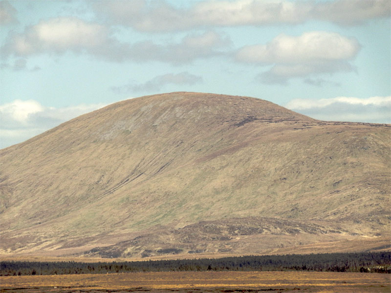
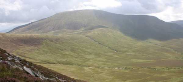
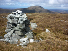
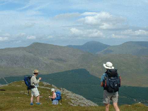
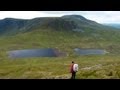
R (F93197 10223). The push up, while only 277m in height gain, was a bit of a trudge up a pathless slope of some 2k. Once there the top, marked by a distinctive stone cairn, was a superb viewing platform for the entire Nephin Beg Range. Prominent to the NNW was Slieve Carr, regarded as the most remote top in the Nephin Begs, while SW was Glenamong, Bengorm and the mountains of Corranbinna. ENE was the distinctive profile of Nephin and the tops of Birreencorragh, a memorable 360 degree panorama. As we had decided on a circular route for our walk, rather than return by way of ascent, we headed NE along the summit plateau to Pt. 617 S (F935 105). While we were relaxing for a short break we noticed a prominent white band near the top of distant Nephin and were surprised to find, through a monocular that this was snow, in May! From Pt. 617 we then headed due E for some 300m to gain the start of a spur T (F938 105) going NE and then a further 200m along U (F940 106) we changed direction to due E to go steeply down a sharp topped rocky spur, before veering ESE to make for a small cleared area in the forest below V (F94945 10414), crossing a fence on the way. From here it was a short walk down the grassy slope and then along the left bank of a small stream to an unsurfaced but good quality forest road W (F95176 10434), some 3.6k from Nephin Beg summit.We turned right and followed the forest road for some 5k back to the start point for the walk at the Brogan Carroll Bothy. In total our route was 15k. In clear conditions, such as we experienced, the need for a number of the map references that I have given would be questionable but in mist this is a pathless and at times featureless terrain in which it would be better to be safe rather than sorry. Linkback: mountainviews.ie/summit/233/comment/6817/
Read Less
Read More

            MountainViews.ie picture about Nephin Beg (<em>Néifinn Bheag</em>)
milo on Nephin Beg
by milo 23 Aug 2003
Gives its name to the range, though it is neither the highest nor the most attractive peak. It can be accessed from the Bangor Erris trail but is not linked to any other summit. A long day could permit Slieve Car and Nephinbeg to be taken either by walking above the Bangor trail or as an out and return from Srahmore at its southern end.Photo shows it as the flat topped summit at the R.H.ofthe picture, with Slieve Car 721m in the centre and Glenamong mountain and valley to the left. Linkback: mountainviews.ie/summit/233/comment/618/
Read Less
Read More

Nothing to see but cloud!
by Geo 25 Jul 2010
Following on from Nephin Beg South we took less than an hour to make it to the real summit of Nephin Beg. As already said the meteorological situation i.e. the drizzle/mist and the strong breeze driving this through our not so waterproof clothes meant we had to use our map/compass and God save us, the GPS! Unfortunately again I can't say what the views are like, needless to say we didn't hang about but went on towards Corslieve/Slieve Carr. We dropped off by the Western slope and then North along the ridge to Corslieve with the lke to our right. Linkback: mountainviews.ie/summit/233/comment/5970/
Read Less
Read More

Remote or Not
by sandman 24 Aug 2015
Yes........This part of Mayo is remote or is it ...............as you can drive a normal road vehicle to L Avoh Ht (F94109 07375) where there is ample parking and no restrictions on entry or exit......see my comment on Aroher Hill ..sure makes Nephin Beg S Top and Nephin Beg an easy up and down. Linkback: mountainviews.ie/summit/233/comment/18265/
Read Less
Read More
EDIT Point of Interest
text
Videos


Recent Contributions
x
Conditions and Info
Use of MountainViews is governed by conditions and a privacy policy.
Read general information about the site.
Opinions in material here are not necessarily endorsed by MountainViews.
Hillwalking is a risk sport. Information in comments, walks, shared GPS tracks or about starting places may not be accurate for example as regards safety or access permission. You are responsible for your safety and your permission to walk.
See the credits and list definitions.

OSi logo
OSNI/LPS logo
Open Street Map
(Various variations used.)
British summit data courtesy:
Database of British & Irish Hills