Members and Supporters, the MountainViews Committee requests your help to meet the costs of the website and of other activities such as insured events or publications.
Feature count in area: 34, all in Galway,
OSI/LPS Maps: 37, 44, EW-CON, MSW
Highest Place: Benbaun 729m
Starting Places (48) in area Twelve Bens: Angler's Return, Barr na nÓran Road, Ben Lettery Hostel, Bogville Road, Bridge St Clifden, Bundorragha Estuary Cross, Bunnageeha, Cannaclossaun, Connemara Mountain Hostel, Connemara National Park Visitor Centre, Dernasliggaun, Doire na bhFlann North, Doughruagh CP, Emlaghdauroe Bridge, Emlaghdauroe South, Fee Lough SW, Foher, Glasbeg Stream, Glashmore Bridge, Glencoaghan River Bridge, Glencraff Road End, Gleninagh River, Illaunroe North, Illaunroe South, Inaghbeg Path, Kylemore Abbey Exit, Kylemore River, Letterfrack Lodge, Lettergesh Beach, Lough Anivan Bend, Lough Auna S, Lough Fee East, Lough Nacarrigeen S, Lough Tanny, Muck Lough NW, Nambrackkeagh Lough, Owen na Baunoge River, Owengar Bridge, Owenglin River, Owenwee River, Pollacappul Lough E, Pollacappul Lough W, Shanvally, Skeaghatimull, Ten Bens Cottage, Tooreennacoona River, Western Way Cnoc na hUilleann, Western Way Inagh Cottages
Summits & other features in area Twelve Bens: Cen: Lough Auna Hills: Cregg 297m, Townaloughra East Top 216m Cen: Polladirk: Bencullagh 632m, Maumonght SW Top 454m, Diamond Hill 442m, Knockbrack 442m, Maumonght 602m E: Glencorbet: Benbaun 729m, Benbrack 582m, Benbaun 477m, Knockpasheemore 412m, Benfree 638m, Muckanaght 654m N: Doughruagh: Altnagaighera 549m, Benchoona 581m, Benchoona East Top 585m, Currywongaun 273m, Doughruagh 526m, Doughruagh South Top 525m, Garraun 598m, Garraun South Top 556m, Letterettrin 333m SE: Glencoaghan Loop: Bencollaghduff 696m, Benglenisky 516m, Benlettery 577m, Bencorr 711m, Bencorr North Top 690m, Bencorrbeg 577m, Binn an tSaighdiúra 653m, Benbreen 691m, Benbreen Central Top 680m, Benbreen North Top 674m, Derryclare 677m, Bengower 664m
Note: this list of places may include island features such as summits, but not
islands as such.
Bencullagh, 632mMountain An Chailleach A name in Irish,
Place Rating ..
(Ir. An Chailleach [OSI], 'the hag'), Binn na Caillí, Galway County in Connacht province, in Arderin, Vandeleur-Lynam Lists, An Chailleach is the 233rd highest place in Ireland.
Grid Reference L75576 53724,
OS 1:50k mapsheet 37 Place visited by: 220members, recently by: rhw, Prem, Carolineswalsh, SeanPurcell, Ansarlodge, Kaszmirek78, SFlaherty, Kirsty, Carolyn105, konrad, Krzysztof_K, bagoff, farmerjoe, ToughSoles, NualaB
I visited this place: NO (You need to be a logged-in member for this.)
Longitude: -9.876639, Latitude: 53.518942, Easting: 75576, Northing: 253724,
Prominence: 154m, Isolation: 0.7km ITM: 475552 753746 Bedrock type: Pale quartzites, grits, graphitic top, (Bennabeola Quartzite Formation) Notes on name: A woman known as Cailleach an Chlocháin, 'the witch of Clifden', was a famous character in the 19th century.
Short or GPS IDs, 6 char: Bnc632, 10 char: Bencullagh Linkback: https://mountainviews.ie/summit/226/
Gallery for Bencullagh (An Chailleach) and surrounds
Summary
for Bencullagh (An Chailleach):
Part of an E-W or W-E route
Summary created by Colin Murphy
2014-06-24 11:25:04
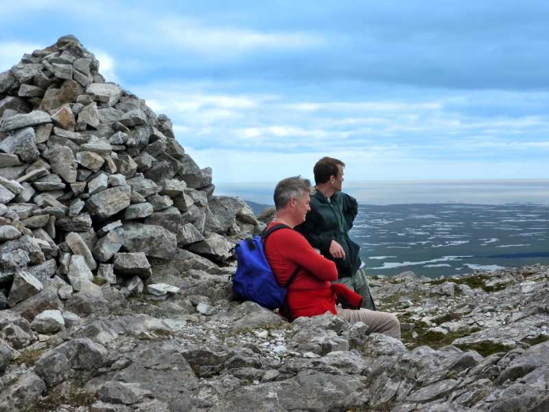
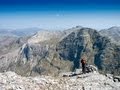
Picture: Enjoying the splendour at the summit cairn
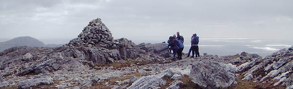
This approach is part of a longer route taking in Benbaun, Benfree and Muckanaght to the east and Maumonght and Maumonght SW Top to the west. Parking on road at Shanvally (L817 566), approx. 2km north of Lough Inagh. Proceed 1km SW directly up minor top called Knockpasheemore, steepish ascent mostly over short grass. From this top, continue SW for 3km first across grass, the terrain becoming increasingly rocky and steep as you ascend Benbaun. From here turn NW for 1km, the ascent of Benfree being fairly gentle. Continue SW for 1km to the summit of Muckanaght, and from there 1km SWW to Bencullagh, the ascent being relatively easy. Summit marked by large cairn.
When approaching from Muckanaght, the climb up to Bencullagh is not as steep or high as the previous climb up to Muckanaght from Benfree. Neither are its northern slopes as steep or rugged as Muckanaght. That being said, it is still an impressive mountain and has great views back to Benbaun, Benbreen and Bencollaghduff, as well as distant views to the myriad lakes leading to Roundstone. Bencullagh also offers a fantastic viewpoint both into the Polladirk and Owenglin River valleys which are to the north and south of it respectively. Linkback: mountainviews.ie/summit/226/comment/5861/
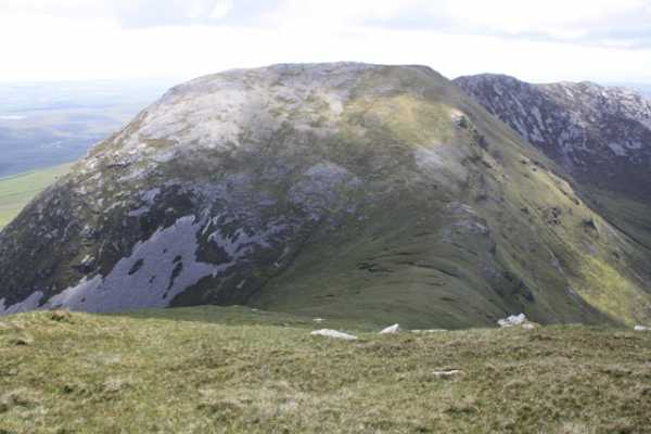
An Chailleach/ Bencullagh, central in this December picture, has whitish quartzite scree slopes reminiscent of just a few other places in Ireland including some of the nearby Bens / Turks and the more distant Great Sugar Loaf (WIcklow) and Errigal. Underfoot the bog is thin and lumps of the quartzite speckle the ground.
The summit to the right, Muckanaght unusually for the Bens has a schist top and its seasonally brown vegetation cover is much more complete, very clear in this view taken from beside one of the many Roundstone Bog lakes. Linkback: mountainviews.ie/summit/226/comment/2932/
Use of MountainViews is governed by conditions and a privacy policy.
Read general information about the site. Opinions in material here are not necessarily endorsed by MountainViews.
Hillwalking is a risk sport. Information in comments, walks, shared GPS tracks or about starting places may
not be accurate for example as regards safety or access permission. You are responsible for your safety and your permission to walk.
See the credits and list definitions.


 Our Facebook page.