Members and Supporters, the MountainViews Committee requests your help to meet the costs of the website and of other activities such as insured events or publications.
Central DingleArea, Cen: Annascaul Lake West
Subarea
Feature count in area: 25, all in Kerry,
OSI/LPS Maps: 70, 71, 78, EW-DC, EW-DE, EW-DW
Highest Place: Beenoskee 826m
Starting Places (34) in area Central Dingle: Anascaul Village, Annascaul Lake, Ballyduff Grave Yard, Brandon Village, Cloghane Community Centre, Conor Pass, Doonore South, Doorah, Dromavally Mountain SE, Emlagh Cross, Emlagh Wood, Farrannakilla School, Glan Mountain, Glanteenassig Lane, Glanteenassig Wood CP, Glennahoo River, Hostel Cloghane Village, Killiney R560 Junction, Kilmore Lodge, Lios Pole Church, Lisduff Rath, Lough Camclaun, Lough Caum, Lough Doon CP, Lougher, Maum Cross, Maumnahaltora Cross, Minard Beach, Mullaghveal Farm, Owenascaul Estuary, Pedlars Lodge, Pilgrimage Trail Owenmore River, Sauce Creek Walkway Dingle Way, Teerbrin
Summits & other features in area Central Dingle: Cen: Annascaul Lake West: Cnoc na Bánóige 641.6m, Cnoc na Bánóige North Top 447.6m, Knockmulanane 593.2m, Knockmulanane West Top 563.5m Cen: Dromavally: Cummeen 477m, Dromavally Mountain 552m, Knocknakilton 423m N: Annascaul Lake North: Coombane 610m, Beenatoor 592m, Beenoskee 826m, Stradbally Mountain 798m N: Carrigdav: Carrigadav 240m N: Fermoyle: Farrandalouge 144m S: Annascaul: Beenmore 252m, Brickany 374m, Knockafeehane 301m, Knocknanacree 286m W: Ballyduff: Slievenalecka 458.4m, Beenbo 476.7m, Slievenagower 485.8m W: Slieveanea: An Cnapán Mór 649m, Knockmoylemore 493m, Croaghskearda 608m, Slievanea 628.7m, Slievanea NE Top 670.7m
Note: this list of places may include island features such as summits, but not
islands as such.
Cnoc na Bánóige, 641.6mMountain
Place Rating ..
(Ir. Cnoc na Bánóige [TCCD], 'hill of the grassy patch'), Banoge Mountain, Kerry County in Munster province, in Arderin, Vandeleur-Lynam, Irish Best Hundred Lists, Cnoc na Bánóige is the 213th highest place in Ireland.
Grid Reference Q54831 04823,
OS 1:50k mapsheet 70 Place visited by: 157members, recently by: chelman7, DeirdreM, rhw, Jimmy600leavey, maoris, Tuigamala, Barrington1978, ToughSoles, Oscar-mckinney, Carolyn105, Jai-mckinney, johncusack, miriam, farmerjoe, NualaB
I visited this place: NO (You need to be a logged-in member for this.)
Longitude: -10.122875, Latitude: 52.176595, Easting: 54832, Northing: 104824,
Prominence: 176m, Isolation: 1km ITM: 454813 604878 Bedrock type: Purple cross-bedded sandstone, (Cappagh Sandstone Formation) Notes on name: Previously Banoge North in MV.
Short or GPS IDs, 6 char: CncnBá, 10 char: CncnBánóg Linkback: https://mountainviews.ie/summit/207/
Gallery for Cnoc na Bánóige and surrounds
Summary
for Cnoc na Bánóige :
Ridge summit with some cliffs and great views.
Summary created by simon3, Colin Murphy, jackill
2022-01-23 09:56:10
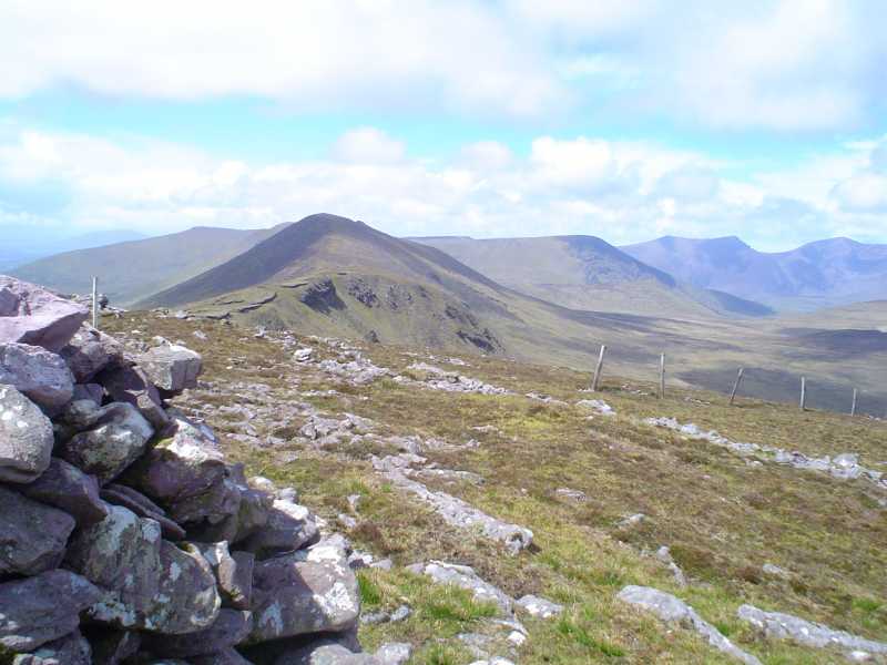
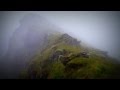
Picture: View from Knockmulanane
From the west: Start from the car park at the Connor pass Conr Ps (Q49054 05587) .
Cross the main road and head due east uphill following a distinct track for 200 meters, then keep east and had for An Cnapán Mór and then to Cnoc na Bánóige
From the east: start from the car park beside Lough Annascaul AnScaul L (Q58253 05092) and ascend directly up the steep eastern slope. This becomes tricky around 400m elevation when you must ascend through a narrow gully which involves some climbing - and a warning - this can be a little dangerous in wet conditions. After that continue directly west for about 500m to reach Knockmulanane and then a further 2km west takes you to the summit, marked by a cairn. The terrain is a mixture of grass and heather and quite uneven. 2.5 hours car to summit.
The views from this ridge are spectacular both to Dingle Bay to the south and the high isolated plateau of Central Dingle.
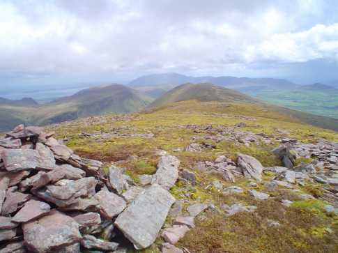
Picture: The summit of Cnoc na Bánóige looking East
jackill on Cnoc na Bánóige
by jackill
6 Sep 2006
From the summit cairn Of Cnoc na Bánóige looking along the ridge to Knockmulane and Dromavally Mountain(slightly to the left).In the background you can make out the Slieve Mish mountains rising up over Tralee.The ridge has no evidence of walker damage even though the views of the Brandons and across Dingle Bay are just stunning. Linkback: mountainviews.ie/summit/207/comment/1714/
Read Less
Read More
three5four0 on Cnoc na Bánóige
by three5four0
1 Oct 2009
See Knockmulanane for the start of this walk
Arrived here from Knockmulanane, on which has been our driest day of our holiday in Dingle. Continued over pt609 (lots of quartz in the rocks) and descended down into Windy Gap. Where we switched direction, walking NE past a right angle turn in the stream at A (Q540 056), turning north past spot height pt364, crossing a fence and then a track (not marked on the map or even the new 1:25,000 Brandon map) to reach the summit of Slievenagower.
Use of MountainViews is governed by conditions and a privacy policy.
Read general information about the site. Opinions in material here are not necessarily endorsed by MountainViews.
Hillwalking is a risk sport. Information in comments, walks, shared GPS tracks or about starting places may
not be accurate for example as regards safety or access permission. You are responsible for your safety and your permission to walk.
See the credits and list definitions.


 Our Facebook page.