Members and Supporters, the MountainViews Committee requests your help to meet the costs of the website and of other activities such as insured events or publications.
Feature count in area: 57, by county: Cork: 32, Kerry: 36, of which 11 are in both Cork and Kerry,
OSI/LPS Maps: 83, 84, 85, 88
Highest Place: Hungry Hill 682m
Starting Places (51) in area Caha Mountains: Ardgroom, Barley Lake North, Bere Island Pier, Caha Pass, Canshanavoe South, Carriganine, Cashelkeelty Stone Circles Carpark, Castletownbere Lifeboat Harbour, Clashduff River Farm, Coolieragh Harbour Road, Coomadayallig Lake Road N, Coomadayallig Lake Road S, Cooryeen Lane, Cummer Lough East Road, Derreenataggart Stone Circle Road, Dromoghty Lough North, Dunboy Wood, Esk Boreen, Eyeries, Fehanah Lane, Garinish Island Pier, Glantrasna Bridge, Glenbeg Lough N, Glengarriff, Glengarriff Nature Reserve CP, Gleninchaquin Waterfall, Gowlaun Lough, Healy Pass, Healy Pass Hairpin, Ilnacullin Car Park, Kenmare Bridge, Knockacullin Lane, Leahill Bog, Leitrim Beg Standing Stone, Lough Inchiquin SE, Magannagan Stream, Molly Gallivan's Visitor Centre, Nora's Cottage, Old Lansdowne School, Owgarriff River Lane, Peg's Shop, Pooleen Wood Car Park, Red Trout Lake, Reenroe Bridge, River Drimminboy Track, Rossmackowen Bridge, Rossmackowen Cemetery, Shronebirrane Farm, Shronebirrane Road, Toberbanaha, Turner's Rock Tunnel
Summits & other features in area Caha Mountains: Cen: Hungry Hill: Coombane 510m, Derryclancy 554m, Hungry Hill 682m Cen: Knockowen: Cushnaficulla 594m, Glenkeel Top 417m, Knockastumpa 398m, Knockeirky 577m, Knockeirky South Top 523m, Knockowen 658m, Stookeennalackareha 412m E: Glengarriff: Derrynafulla SW 375m, Gowlbeg Mountain 362m, Nareera 530m, Nareera North Top 503m, Nareera South-West Top 505m, Shrone Hill 283m, Sugarloaf Mountain 574m, Sugarloaf Mountain Far West Top 560m, Sugarloaf Mountain West Top 565m N: Coomnadiha: Baurearagh Mountain 489m, Caha Far SE Top 555m, Caha SE Top 585m, Coomnadiha 644m, Coomnalack Top 435m, Cummeenbaun 510m, Droppa 522m, Killane Mountain 537m, Killane Mountain South-West Top 533m, Knockagarrane 414m, Knockreagh 500m N: Knockeirka: Barraduff Mountain 400m, Killaha Mountain 400m, Knockeirka 426m N: Knocknagorraveela: Derrysallagh 410m, Feorus East 474m, Knocknagorraveela 507m, Knocknagorraveela NE Top 464m N: Lauragh: Knockanoughanish 386m, Knockatee 330m S: Castletownbere: Disert 205m, Knockanallig (Bear Island) 267m W: Ardgroom: Derryvour Hill 160m W: Eskatarriff: Coomacloghane 599m, Eskatarriff 600.5m, Eskatarriff East Top 532.7m, Knocknaveacal North Top 509.1m, Knocknaveacal South Top 507.2m, Lackabane 603m, Tooreenbaha 408.7m, Tooreennamna 524m, Tooth Mountain 592m W: Knocknagree: Knocknagree 586m, Knocknagree East Top 461m, Knocknagree SE Top 442m, Lackawee 572m, Maulin 621m, Maulin North Top 579m
Note: this list of places may include island features such as summits, but not
islands as such.
Coomnadiha, 644mMountain Com na Daibhche A name in Irish,
Place Rating ..
(Ir. Com na Daibhche [OSI], 'hollow of the hole'), Kerry County in Munster province, in Arderin, Vandeleur-Lynam Lists, Coomnadiha is the third highest mountain in the Caha Mountains area and the 208th highest in Ireland.
Grid Reference V84729 60038,
OS 1:50k mapsheet 85 Place visited by: 108members, recently by: Ianhhill, rhw, Superterence, maoris, ToughSoles, Krzysztof_K, Beti13, Sweeney, osullivanm, Hjonna, chelman7, tryfan, derekfanning, annem, glencree
I visited this place: NO (You need to be a logged-in member for this.)
Longitude: -9.671, Latitude: 51.781341, Easting: 84729, Northing: 60038,
Prominence: 209m, Isolation: 1.5km, Has trig pillar
ITM: 484705 560103 Bedrock type: Purple & green sandstone & siltstone, (Caha Mountain Formation) Notes on name: Dabhach (gen. daibhche), a vessel, vat, press or well, is also used in place-names to refer to some depression or recess; cf. Letterdyfe, Leitir Daibhche, a townland in Connemara where the hole in question may be a cave, and Culdaff, Cúil Dabhcha, Co. Donegal, where it seems to refer to a stone with holes bored in it. The peak named Caha (Ir. Cnoc na Ceachan), although it apparently gives its name to the range as a whole, is actually only a minor bump on the southern shoulder of Coomnadiha. Caha, Ir. An Ceacha, was probably the name of a gorge immediately below, before being transferred to this peak. See Caha Mountains for more on the origin of this name.
Short or GPS IDs, 6 char: Cmndh, 10 char: Coomnadiha Linkback: https://mountainviews.ie/summit/203/
Gallery for Coomnadiha (Com na Daibhche) and surrounds
Summary
for Coomnadiha (Com na Daibhche):
Glantrasna's Highpoint
Summary created by Onzy
2015-07-21 10:06:31
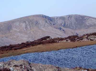
Picture: pic:simon3, Summit from Kilane Mountain
Coomnadiha is the highest point of the hills surrounding the Glantrasna valley.
From the west, on the R571, there is a gated farm track at CrGanine (V80519 60522) with room to park one car without blocking the entrance. From here the track leads almost to the summit of Knockreagh and from there over mixed ground to Coomhadiha. An out-and-back from here should take around three hours. Coomhadiha could also be approached from parking deep within Glantrasna itself, at GlTrasna Bge (V82637 59648), although this involves some steep overgrown ground, particularly at the lower reaches.
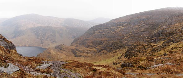
A more complete route is to take in the summit as part of a circuit of the entire valley. Parking at either point allows access to a round taking in Knockreagh, Coomnadiha, Caha (not MV-listed), Droppa and Cummenbaun. In either case an amount of road-walking will be necessary. The entire circuit should take around 6 hours.
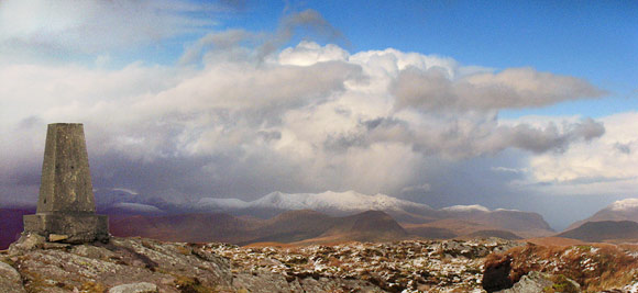
From Coomnadiha there's a great view north over the Kenmare River. The white covered summits are mostly the eastern Macgillycuddy's Reeks at 24k away. The darker double humped summits immediately below them Bascadh and Boughil (just right of centre in the pic). You can just see the tail end of the Dunkerron range, Mothaillín, to their right. (Oh, ok, it was a bit more distinct on the original full size pic.) To the right is the notch of the Gap of Dunloe.
Around 500m NW of the summit this view opens out towards Cummeenadillure Lough, at the head of Glaninchiquin. The summit is on the skyline to the right, while distant Knocknagorraveela is the skyline on the left. The rising ground to the left is marked as Cummeenanimma on the map, however some guidebooks state that this should be known as Eskana.
Use of MountainViews is governed by conditions and a privacy policy.
Read general information about the site. Opinions in material here are not necessarily endorsed by MountainViews.
Hillwalking is a risk sport. Information in comments, walks, shared GPS tracks or about starting places may
not be accurate for example as regards safety or access permission. You are responsible for your safety and your permission to walk.
See the credits and list definitions.


 Our Facebook page.