Members and Supporters, the MountainViews Committee requests your help to meet the costs of the website and of other activities such as insured events or publications.
Feature count in area: 27, by county: Mayo: 15, Galway: 15, of which 3 are in both Galway and Mayo,
OSI/LPS Maps: 37, 38, CBE, EW-CON, MSW
Highest Place: Maumtrasna 682m
Starting Places (53) in area Partry & Joyce: Aasleagh Waterfall CP, An Móinín Mór, Ballydoo Lough, Barrevagh Bridge, Bealanabrack River Tributary, Black Rock, Bohaun, Bracklagh, Buckaun, Bunduvowen, Cammanagh, Carraig Bar, Carrowrevagh Lough, Clonbur, Cummer, Derrassa, Derrinkee Wood, Doon Rock, Failmore River, Finny Church, Fooey River Road, Glendavock, Glenmask, Glennacally Bridge, Glensaulmore Trailhead, Glentraigue, Gowlaunlee Lake, Keelkill North, Killeennimat Burial Ground, Knockaunnabausty (Cnocán na bPáistí), Knocknafaughy SW, Lecarrow, Leenane, Leenane Hotel, unuseableLeenane R336, Lough Nambrackkeagh, Maum Bridge Road Lower, Maum Bridge Road Mid, Maum Bridge Road Upper, Mount Gable CP, Otter Pool, Owenbrin Bridge, Owenbrin Tributary, Owenduff River, Red Island, RIC Barracks Ruin, Rinavore East, Rinavore SW, Shanafaraghhaun Cross, Sheeffry Pass, Tawnyard Lough, Teevinish West, The Larches Pub
Summits & other features in area Partry & Joyce: Cen: Finny: Glenbeg East 372m Cen: Knocknafaughy: Knocknafaughy 254m, Rinavore 426m Cen: Maumtrasna: Barnahowna 516m, Buckaun East 495m, Glennagleragh Mtn 617m, Knocklaur 518m, Maumtrasna 682m, Maumtrasna North-East Top 572m, Tullymorehill 279m N: Ballintober Hills: Bohaun 393m, Corveagh 233m, Croaghrimkarra 271m, Keelkil 239m SE: Cornamona: Mount Gable 417.8m, Bohaun 424m, Knocknagussy 456m SW: Bunnacunneen: Ben Beg 560m, Bunnacunneen 575m, Bunnacunneen South Top 539m, Bunnacunneen SE Top 479m, Lugnabrick SW Top 494m, Lugnabrick NE Top 494m W: Devilsmother: Devilsmother 645m, Devilsmother South Top 509m, Devilsmother North Top 595m, Devilsmother Far North Top 601m
Note: this list of places may include island features such as summits, but not
islands as such.
Devilsmother, 645mMountain Binn Gharbh A name in Irish,
Place Rating ..
(Ir. Binn Gharbh [TR], 'rough peak'), Binn Garbh, Galway/ Mayo County in Connacht province, in Arderin, Vandeleur-Lynam Lists, Binn Gharbh is the second highest mountain in the Partry & Joyce area and the 207th highest in Ireland. Binn Gharbh is the most westerly summit in the Partry & Joyce area.
Grid Reference L91568 62447,
OS 1:50k mapsheet 37 Place visited by: 251members, recently by: rhw, Hjonna, taramatthews, srr45, maoris, PiotrR, Carolineswalsh, learykid, Kaszmirek78, Carolyn105, Moirabourke, overthehill67, Krzysztof_K, bagoff, farmerjoe
I visited this place: NO (You need to be a logged-in member for this.)
Longitude: -9.638619, Latitude: 53.600824, Easting: 91568, Northing: 262447,
Prominence: 280m, Isolation: 0.8km ITM: 491544 762467 Bedrock type: Sandstone & conglomerate, ignimbrite, (Mweelrea Formation) Notes on name: An anglicised form of Binn Gharbh is found in some sources, e.g. Ben Garrif on Bald's map of Co. Mayo (1830) and Bengoriff on the map accompanying Knox's The history of the County of Mayo (1908). The Discovery map has Magairlí an Deamhain, 'the demon’s testicles', as the Irish name. This, however, appears originally to be the name of a knobbly ridge located north of the summit (see Devilsmother North Top), whereas Binn Gharbh applies to the hill as a whole. The English name Devilsmother appears to have some relationship with Magairlí an Deamhain, either being a euphemistic false translation or deriving from a variant name. The Caoránach, the female demon of Irish mythology, whom St. Patrick banishes to Lough Derg, is also known as the Devil's Mother, though there is no evidence to support a connection with this hill. For a road walk in Glannagevlagh, see Walking in Connemara, 8.1.
Short or GPS IDs, 6 char: Dvlsmt, 10 char: Dvlsmthr Linkback: https://mountainviews.ie/summit/202/
Gallery for Devilsmother (Binn Gharbh) and surrounds
Summary
for Devilsmother (Binn Gharbh):
Don't be afraid of the name!
Summary created by Colin Murphy, wicklore
2016-06-02 08:58:06
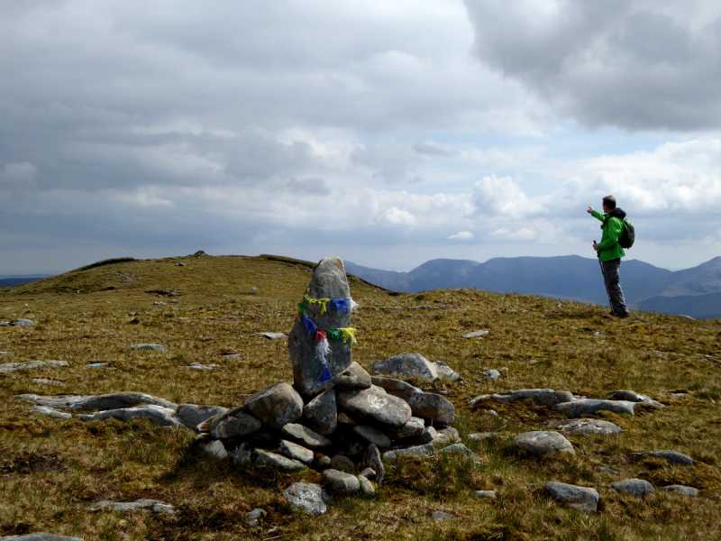
Picture: Devilsmother summit cairn in distance
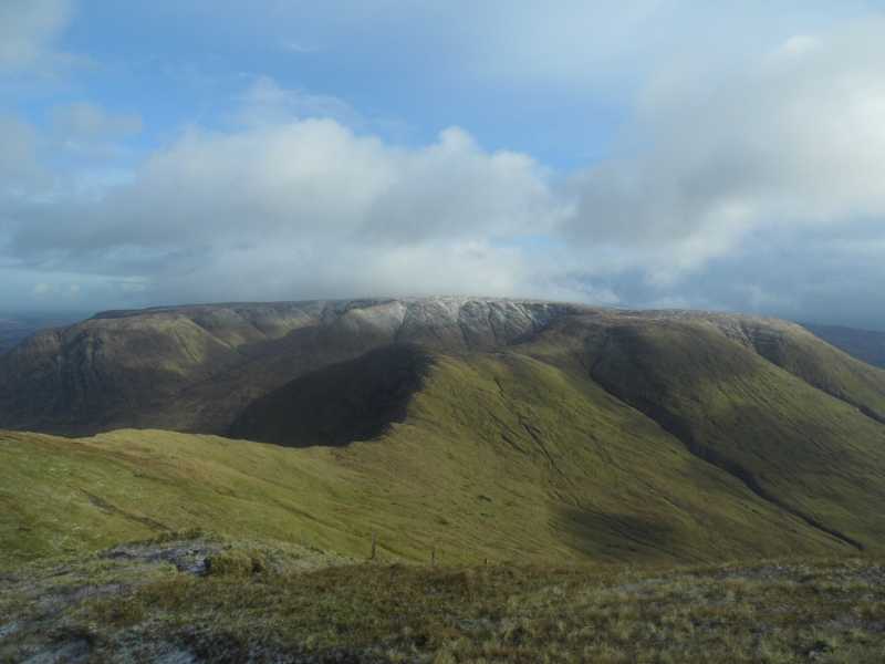
Devilsmother is at southern end of long ridge stretching north to the secondary Devilsmother N Top summit above Killary Fjord. No easy approach as access is up steep slopes. When wet, slopes present quite a challenge.
There is room for several cars in a lay by next to the bridge at A (L935 655) on the N59 road. Go through a gate at the lay by and cross the river to access a track. Follow the track for 400 metres to its end before turning SW to head for the steep slopes of the ridge. The steep climb begins at B (L929 648). The summit of the North Top is reached at C (L919 643).It is then a relatively easy walk along the wide ridge to the main Devilsmother summit about 2kms distant.
Another approach can be made from Fooey Rd (L936 611) which is the end of a minor road. A climb of 400 metres over 2 km can be made up to the ridge connecting Knocklaur and Devilsmother. Turn left for another 200 metre climb up steep ground to the main Devilsmother summit.
A third option is more direct, but very steep. Park at small layby (1 car) at Otr Pl (L912 650) and proceed directly up steep slope in SE direction. Terrain is short grass mostly, and was solid underfoot in late May. Reach the ridge at D (L917 640) after 1 hour 20 minutes and turn almost directly south for 2km, with 95 of the climbing behind you. Pic shows cairn in distance.
Video short summary: https://www.youtube.com/watch?v=8Ov_Ocb8Agw&feature=youtu.be
This route starts out from Carraig Bar on the N59 a few kilometers North of the village of Leenaun at Carig Bar (L89462 63331) and takes in Devilsmother and Devilsmother South Top in a horeseshoe walk around the Glennagevlagh valley. From the bar head North along the N59 for a hundred meters and there is a gate on the right which will give access to the open mountain. A steep climb along the shoulder for about 2.5 kilometres will have you at the summit. From here head South dropping down to the South Top before continuing in a North West direction along the flat southern ridge of the Glennagevlagh valley. Following this will lead down to the N59 and from here it's a short trek back to Carraig Bar. The southern ridge is quite a flat boggy expanse and can seem quite dull after the magnificent Devilsmother summit so a better option might be to follow the river down to the valley which will also lead back to the N59. Linkback: mountainviews.ie/summit/202/comment/20348/
Read Less
Read More
eoin on Devilsmother
by eoin
4 Mar 2003
A typical Connemara mountain - the route we chose started just along the side of the road on the way to Westport out of Leenane. We climbed roughtly 1/3 of the way from the eastern end of the mountain about 200m to the right of the large gully as you look at the mountain. There is no path, trail or hint of the best route so we accessed the field via a farm gate. Crossing 50m of field we went basically straight up for 600m to the ridgeline. It is a steep grassy slope, wet in spots but not exposed. Once on the ridge it is an easy stroll to the main summit on the western end overlooking Killary Harbour and Leenane. The views of the Twelve Bens, Mweelrea and other ridges are excellent. Just to the north of the summit a second small cairn marks the point where you descent following the slow eastward sweep back down to the road and a cluster of houses and farm buildings. A short walk along the road back to the start. The photo shows the Devil's Mother, looking East from the ridge we followed down, you will note the 45-50 degree slope we climbed viewed in profile. Linkback: mountainviews.ie/summit/202/comment/364/
Read Less
Read More
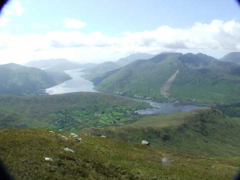
Picture: A view from Devilsmother to Killary Harbour and the ascent route
Himiwack on Devilsmother
by Himiwack
31 May 2009
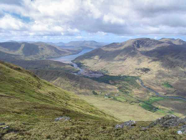
Climbed Devilsmother on 2007-06-03. Was a beautifull sunny sunday. Started the walk on the east end of Killary Harbour by the last pub in county Galway. There is no path to climb but it´s easy to find a way to the ridge. Followed the ridge which is the Mayo/Galway border in southeast direction. Then turned the direction to east and climbed the last steep ascent to the summit of Devilsmother. Here are brilliant views to Killary Harbour, Mweelrea and Maamturk Mountains. Back on the ascent way. The walk takes about 3,5 houres. Linkback: mountainviews.ie/summit/202/comment/2741/
Read Less
Read More
Picture: Killary Fjord Panorama From Devilsmother
Great mountain, excellent views
by ahendroff
11 Jul 2010
This is an mountain with excellent views from its summit (see photo), so best to leave for a clear day. It can be climbed as a short there-and-back, or linked in with Maumtrasna as a longer walk. I opted for the latter, as it was a glorious May day and I felt energised after doing the Sheffry hills the day before. If you haven't done this summit before, plan it now! You won't regret it ... Linkback: mountainviews.ie/summit/202/comment/3047/
Read Less
Read More
Dan on Devilsmother
by Dan
15 Oct 2004
Walked to this peak by crossing the ridge from Maghairli an Deamhain. This is a nice easy walk and takes about half an hour. This mountain is really worth the effort on a nice day because the views of the twelve bens and the mweelrea mountains are fantastic. Linkback: mountainviews.ie/summit/202/comment/1250/
Use of MountainViews is governed by conditions and a privacy policy.
Read general information about the site. Opinions in material here are not necessarily endorsed by MountainViews.
Hillwalking is a risk sport. Information in comments, walks, shared GPS tracks or about starting places may
not be accurate for example as regards safety or access permission. You are responsible for your safety and your permission to walk.
See the credits and list definitions.


 Our Facebook page.