Donation Request 2024

DONATE
Members and Supporters, the MountainViews Committee requests your help to meet the costs of the website and of other activities such as insured events or publications.
You do not have to be logged in to donate.
Features
Nearby features appear when you click the map.
Declutter tracks on map.
Place Search
Video
X
Pub: by
Dublin Area , S: Kippure & Kilbride Subarea
Feature count in area: 18, by county: Dublin: 16, Wicklow: 7, Kildare: 1, of which 6 are in both Dublin and Wicklow, OSI/LPS Maps: 43, 50, 56, AWW, EW-DM, EW-WE, EW-WW
Highest Place: Kippure 757m

Starting Places (77) in area Dublin:
Allagour Road, Ballinascorney Golf Club, Ballylerane, Ballylow Bridge, Ballyreagh Wood, Ballyross Forest, Ballysmuttan Long Stone, Barnaslingan Wood, Bohernabreena North CP, Boranaraltry Bridge, Bray Harbour, Cabinteely House, Cannon's Corner, Carrickgollgan, Castelkelly Bridge, Clonkeen Road South, Cloon Wood Cp, Cransillagh Brook , Crone Wood CP, Cruagh Forest Recreation Area, Cruagh Road Hairpin, Curtlestown Wood CP, Dunnes Bank, Enniskerry, Fernhill Estate, Gap Road, Garadhu Road, Glencree Reconciliation, Hell Fire Wood CP, Johnnie Fox Pub, Kilbride Army Camp Entrance, Kilgobbin Lane, Killakee Car Park, Killiney Hill Carpark, Kilmashoge Forest CP, Kilsaran Quarry, Kippure Bridge, Kippure Estate, Kippure Transmitter Gate, Knockbrack, Knockree west, Lackan Wood S, Lamb Doyles, Laughanstown Luas, Lee's Lane, Liffey Bridge, Liffey Head Bridge, Lough Bray Lower, Lough Bray Upper, Lynch's Park Road, Marley Park CP, Novara Avenue, Bray, Old Wicklow Way entrance, Pavilion Theatre, Pine Forest Road, Putland Road, Raheenoon, Rathmichael RC Church, Rathmichael Wood CP, Sally Gap, Sally Gap N, Seahan 265', Seahan 300', Sean Walsh Park, Seefin Trailhead, Shankill Byrnes Bar, Shankill Tributary Bridge, Slademore Road, Sraghoe Brook, St Catherine's Park, The Lamb Hill, The Scalp, Tibradden Forest Recreation Area, Tibradden Lane, Ticknock Forest, Vance's Lane, Wyattville Close

Summits & other features in area Dublin:
N: Howth: Ben of Howth 171m
N: Naul: Knockbrack 176m
S: Dublin South East: Carrickgollogan 275.2m, Glendoo Mountain 585.1m, Killiney Hill 153.5m, Knocknagun 555.3m, Montpelier Hill 383m, Prince William's Seat 553.5m, Tibradden Mountain 466.2m, Two Rock Mountain 536m
S: Kippure & Kilbride: Corrig Mountain 617.1m, Kippure 757m, Seahan 647.3m, Seefin 620.6m, Seefingan 722.9m
S: Saggart: Cupidstown Hill 378.6m, Knockannavea 400.8m, Saggart Hill 396.9m

Note: this list of places may include island features such as summits, but not islands as such.
Rating graphic.
Seahan, 647.3m Mountain Suíochán A name in Irish,
Place Rating ..
(Ir. Suíochán [PWJ*], 'seat' ), Seechon, Suidhe Mhic na Baintrighe, Dublin County in Leinster province, in Arderin, Vandeleur-Lynam Lists, Seahan is the third highest mountain in the Dublin area and the 205th highest in Ireland. Seahan is the third highest point in county Dublin.
Grid Reference O08119 19696, OS 1:50k mapsheet 56
Place visited by: 602 members, recently by: emermcloughlin, Padraigin, rhw, Courin, KateLeckie, taramatthews, davidrenshaw, Prem, Carolineswalsh, Tommer504, Tuigamala, McWobbley, ToughSoles, muddypaws, Sonyalaw
I visited this place: NO (You need to be a logged-in member for this.)
Longitude: -6.382208, Latitude: 53.216951, Easting: 308120, Northing: 219697, Prominence: 93.8m,  Isolation: 1km, Has trig pillar
ITM: 708045 719726
Bedrock type: Dark slate-schist, quartzite & coticule, (Butter Mountain Formation)
Notes on name: Seahan has two megalithic cairns on its summit. Liam Price noted that Seahan appears on the Down Survey maps as Seavick na bantree and rightly interpreted this as Ir. Suidhe Mhic na Baintrighe, 'seat of the widow's son'. However, he believed that the story behind the name would never be understood: This curious name must have some reference to old traditions about the ancient burial cairns which crown the top of this mountain. All such traditions about this place have long ago disappeared (The Antiquities and Place Names of South County Dublin, Dublin Historical Record, vol. ii, no. 4, 121-33). While the precise story may never be recovered, it should be noted that Mac na Baintrí, the widow's son, is a common figure in Irish folktales whose characteristics are eternal persistence and ingenuity in the face of adversity.
  Short or GPS IDs, 6 char: Seahan, 10 char: Seahan

Linkback: https://mountainviews.ie/summit/200/
Gallery for Seahan (Suíochán) and surrounds
Summary for Seahan (Suíochán): Airy views over Kildare from this well positioned peak.
Summary created by Peter Walker, simon3, wicklore, YoungJohn 2015-03-16 19:51:39
            MountainViews.ie picture about Seahan (<em>Suíochán</em>)
Picture: Seahan from the SW
Seahan is one of the four hills in the so called ‘Circuit of Kilbride’. Kilbride Rifle Range is an Army range on the Dublin/Wicklow border and it is nestled in a valley surrounded by Seahan, Corrig, Seefingan and Seefin. In fact these summits mark the boundary of the Rifle Range (Although strictly speaking the boundary passes within 150 metres of Seahan’s summit)
A minor road leads from Bohernabreena in Dublin past the entrance to the Range. Seahan can be reached from this road at A (O073 200) for example. At about 480 metres altitude this leaves a 160 metres climb to Seahan. There are remains of several megalithic tombs on Seahan. There are also good views towards Dublin and across to Seefingan and Seefin.
Because of the rather featureless nature of these hills it could be easy to become disoriented in poor weather which could mean an unintended descent into the Rifle Range. Seahan itself is generally ok underfoot, but the wider circuit includes some very wet and boggy cols. Also scramblers and quad bikes have churned up the bog in many places.
Linkback: mountainviews.ie/summit/200/comment/4960/
Member Comments for Seahan (Suíochán)
Comment create / edit display placeholder

            MountainViews.ie picture about Seahan (<em>Suíochán</em>)
Picture: Sitting room
padodes on Seahan
by padodes 2 Feb 2009
The name Seahan is said to come from ‘Suíochán’. On the Down Survey map of 1655 and on Rocque’s map of 1760, the mountain is called “Seavick na Bantree”, an anglicisation that suggests the translation ‘Seat (Suí) of the Widow’s Son’. The word “Suí” in one combination or another keeps coming up in other hilltop names in this area as well (Seefin, Seefingan), and it clearly refers in each case to the large megalithic tombs on those mountains. If we remember that the old Fenian Cycle in Irish literature situates some of the heroic feats of Finn MacCool and the Fianna in nearby Glenasmole and the hills around, I think it’s easy to understand how the popular imagination would see in these giant ‘seats’ the haunts of our Celtic supermen. Seefin (Suí Finn), just 3.5 kms to the south of Seahan, makes the association explicit.

There are no less than three megalithic tombs on Seahan. The cairn to the east is a passage tomb, over 21m in diameter, with a kerb of elongated granite stones. On top of the cairn can be seen the capstone (visible in the photo) over the central chamber. The second cairn, now topped with a trig pillar, is almost 24m in diameter and 2m high. It appears never to have been opened. A short distance further west lie the shattered remains of a wedge tomb – a kind of burial that is considered unusual above 300m.

Seahan can easily be included in a circuit that includes Corrig (the only top without a megalithic monument), Seefingan and Seefin. It’s a walk I have recorded as being approximately 12 kms. The route practically follows the boundary line and, indeed, the stumpy granite boundary markers (one of which sits atop the cairn on Seefingan) around the military firing-range of Kilbride and loops back along the stretch of road in front of it. To enjoy this walk, you definitely need either a good dry spell beforehand, or preferably hard frost. Otherwise, be prepared to get an unpleasant sinking feeling along many a stretch. Linkback: mountainviews.ie/summit/200/comment/3552/
Read Less
Read More

            MountainViews.ie picture about Seahan (<em>Suíochán</em>)
Picture: Resting in peace
padodes on Seahan
by padodes 9 Mar 2010
The OS sheet only indicates a cairn and megalithic tomb on top of Seahan, but there is also a wedge tomb only a stone’s throw just west of these two. To my mind, it’s the most photogenic of all three, despite the few shattered slabs that remain. It has had perhaps four thousand years of history wash over it and still resists. It has seen off the heroic huntsmen of the Fianna who allegedly roamed these hills and will see off too the mud-bespattered bikers who now rake up the earth around it. If you are looking for a little taste of timelessness, why not nestle down in the tomb and think yourself back into the mysterious world of the Neolithic chieftain who was once laid in it? Maybe the whisper you hear will not only be the rustle of the wind in the heather… Well, it’s just a suggestion.

Normally such tombs were not built above 300m, but this one lies at twice that height. Considering the many other tombs that bedeck all of these hills, one might sometimes feel like being in a necropolis here. In the photo, you can see Seefingan on the left, with its cairn, and Seefin on the right, with its impressive passage grave. Those living in the plains below could never have felt that their dead were far away.

In the photo you can also make out in the distance the snowy top of Mullaghcleevaun, with its north-facing corrie. Linkback: mountainviews.ie/summit/200/comment/4494/
Read Less
Read More

            MountainViews.ie picture about Seahan (<em>Suíochán</em>)
Seahan Summit
by Dessie1 25 May 2010
A very quick hike up Seahan starts the first of 4 mountains.Seahan,Corrig mt,Seefin and Seefingan Linkback: mountainviews.ie/summit/200/comment/5828/
Read Less
Read More

            MountainViews.ie picture about Seahan (<em>Suíochán</em>)
Picture: Faraway Hills
padodes on Seahan
by padodes 1 Feb 2009
Looking southwards from Seahan, the hazy planes of several hills seem to overlap in the distance: Seefingan, Seefin, Sorrel. In reality, they form, together with Seahan, a wide arc, with Seefingan at 2.67 kms distance, Seefin at 3.52, and Sorrel at 8.70, as the crow flies. They are all linked, too, through the presence of megalithic cairns on each one. The distant mounds are perfectly visible in the photo, at least at full resolution, and are not exactly on the summit of each hill but slightly lower down to the west, facing out across the fertile plain that laps up against the hills of north-west Wicklow, along the borders with Kildare and Dublin.

The picture that archaeology provides of this area gives enormous added interest to walking in these hills. It takes us back to the development of farming in neolithic times, when organised communities cultivated here the lowland fringes of the central plain, yet buried their eminent dead in elaborate hilltop tombs. The similarities in construction and symbolism all point to a common social and religious outlook that one would love to be able to grasp.

As far as the hills themselves are concerned, one thing that leaves me pensive is the fact that, even at that early stage, the human impact on the terrain was already quite notable. From an examination of the pollen record preserved deep in the bog (and one such study was made precisely in the area between Seefin and Seefingan), there is evidence of the prehistoric clearance of trees for pasture and of the later burning of the moorland that replaced the woods. Today we complain of the ugly clear-felling of forest and the recurring summertime ritual of turning the heather to ashes, but, for better or for worse, these are things that have been carried on here in the hills for well over four thousand years! Linkback: mountainviews.ie/summit/200/comment/3551/
Read Less
Read More

            MountainViews.ie picture about Seahan (<em>Suíochán</em>)
Picture: Imprompto ice sculpture atop snow-blasted bracken near 5,300 year old Megalithic cairn.
Normal walk up Dublin Neighbour turns into Ethereal Christmas Cairnscape!
by Ronan119 2 Jan 2021
Walked up to Seahan in December from the forest path coming up from Ballinascorney.
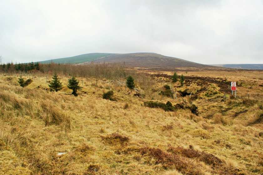
Walked through the forest and saw a herd of Shetland ponies coupled with a larger Horse of unknown breed. After getting over the fence, (I do not recommend this route!) I got to the main track which runs parallel with the Dodder/Bohernabreena reservoir
below, rapidly passing out routing fairweather walkers who had evidently not bargained for the encroaching mist, or gods help them, actual height of the mountains.

At this stage, there was almost no sound, and the corpses of cut down trees which garnish the ground cast ghoulish shadows worthy of any great war reenactment.
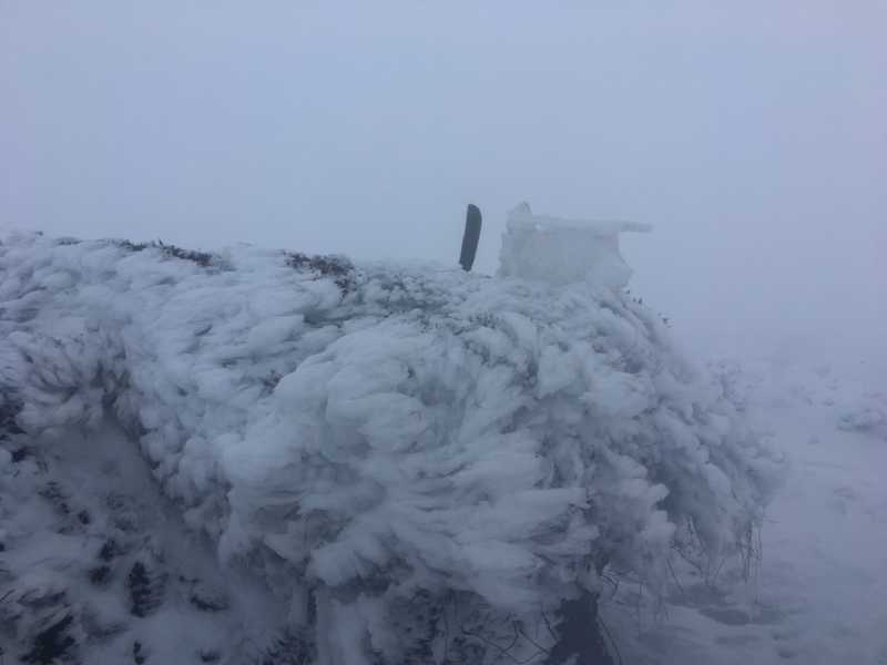
As the mist grew fatter, I heard a strange noise piercing the mountainside, and my imagination summoned Demons of ancient myth from Fomorians to Fir Bolg. I also knew I was now a star of a 'think we're alone now' cover. However I realized what the unwelcome sight was: a solo Quad-biker who felt utterly entitled to churn up the trackway (which is already in a sorry state), though he was actually polite - I resisted the urge to pull a Braveheart on him for his environmental sacrilege, nonetheless I feel this should not be encouraged. Not long after, I noticed ice sheeting the rivulets of water which trickled off the hillside, and finally I reached the snowline, where layered feathers of the North Pole's best transformed the scene into a soundless moonscape. Stalagmitic daggers hung off the nearby bogland, and I noticed a sculpture of ice somebody had erected atop some bracken nearby - to which I added an axelike shard of rock from nearby. I pressed on and, only 100 metres away, the Cairn emerged from the mist like the prow of a ship near some far-flung glacier.

I stood on the Cairn (which has centuries on the Pyramids and was already ancient when the Romans first conquered our Welsh neighbours). The so-called 'Ava's monument' on top had been blasted by ice and yet there was almost no wind. Indeed the scene was a churchlike silence to which I can do justice only by encouraging repeat walks by others when similar conditions allow and align. Tried being smart and covering a new route on the way back as the darkness rose-all I will say is, don't do that. Anyway. Some say the ancients believed these monuments were a gateway to another world. After my experience, I can't say as they were wrong. Linkback: mountainviews.ie/summit/200/comment/21950/
Read Less
Read More
EDIT Point of Interest
text
Videos


Recent Contributions
x
Conditions and Info
Use of MountainViews is governed by conditions and a privacy policy.
Read general information about the site.
Opinions in material here are not necessarily endorsed by MountainViews.
Hillwalking is a risk sport. Information in comments, walks, shared GPS tracks or about starting places may not be accurate for example as regards safety or access permission. You are responsible for your safety and your permission to walk.
See the credits and list definitions.

OSi logo
OSNI/LPS logo
Open Street Map
(Various variations used.)
British summit data courtesy:
Database of British & Irish Hills