Members and Supporters, the MountainViews Committee requests your help to meet the costs of the website and of other activities such as insured events or publications.
Feature count in area: 62, by county: Cork: 45, Kerry: 24, of which 7 are in both Cork and Kerry,
OSI/LPS Maps: 78, 79, 85, 86, 88, 89
Highest Place: Knockboy 704.8m
Starting Places (47) in area West Cork Mountains: Barley Lake North, Barrboy, Caha Pass, Carranmore, Carrigacappeen, Carriganass Castle, Castle Donovan Car Park, Clearagh House, Coolkellure House, Coomhola Bridge, Corrigatirra, Cousane Gap, Cummer Lough East Road, Derreencollig Wood, Esk Boreen, Fuhiry Wood, Garinish Island Pier, Glasagarav River Bridge, Glasnacummeen Stream, Glengarriff, Glengarriff Nature Reserve CP, Gorteeniher Drimoleague Heritage Walk CP, Gortloughra River Road, Gougane Barra Oratory, Gougane Barra Park CP, Grousemount Wind Farm, Kealkill Village, Knockanuha, Knockbrack South, Lough Atooreen N, Lough Nambrackderg North, Lough Nambrackderg Wood, Lough Nambreacdearg, Mealagh Bridge, Molly Gallivan's Visitor Centre, Nowen Hill West Road, Owvane River Bridge, Pookeen North Top Road, Pooleen Wood Car Park, Priests Leap, Reenroe Bridge, River Roughty, Shandrum Concrete Silo, Sillahertane Stream, Slaheny River Horseshoe, Top of Coom, Turner's Rock Tunnel
Summits & other features in area West Cork Mountains: Cen: Maughanaclea: Maughanaclea Hills East Top 470m, Maughanaclea Hills West Top 452m Cen: Shehy More: Shehy More 545.6m, Shehy More SW Top 446m E: Clearagh: Clearagh Hill 287m E: Currane: Currane Hill 228m N Cen: Douce: Douce Mountain 476m, Doughill Mountain 471m N: Carran: Barnastooka 497m, Bealick 537m, Carran 604m, Carran Far NE Top 561m, Carran Far North Top 506m, Carran NE Top 555m, Carran South Top 567m, Knockantooreen 450m N: Conigar: Conigar 566m, Conigar SW Top 566m, Foilastookeen 540m N: Coomataggart: Carrigalougha 423m, Coomataggart 530m, Coomataggart SW Top 509m, Derrineanig 304m, Lackabaun 472m, Mweelin 487m NE Cen: Carrigarierk: Carrigarierk 343m NW: Barraboy: Barraboy Mountain 460m, Barraboy Mountain Far East Top 456m, Barraboy Mountain SE Top 409m, Derroograne 468m, Turners Rock 420m NW: Knockboy: Caoinkeen 692.8m, Caoinkeen South-East Top 553.5m, Coomhola Mountain 472m, Knockboy 704.8m, Knockboy North Top 651.2m, Knockboy South Top 533.3m, The Priest's Leap 519m NW: Knocknamanagh: Bird Hill 412m, Coomclogherane Top 449m, Gullaba Hill 603m, Knockbrack 440m, Knockbrack South Top 458m, Knocknamanagh 637m, Knocknamanagh NE Top 625m S Cen: Dunmanway Hills: Cashloura 296.8m, Coolsnaghtig 295.8m, Inchanadreen 310m S Cen: Nowen: Milane Hill 354.4m, Mullaghmesha 494.3m, Nowen Hill 535.2m, Nowen Hill Far West Top 405.2m, Nowen Hill SW Top 509m, Pookeen North Top 319m S: Leap Hills: Carrigfadda 311.7m, Killeigh Hill 229m, Knockarudane Hill 169m, Knockscagh 195m S: Skibbereen: Barryroe Hill 156m, Lick Hill 158m W Cen: Knockbreteen: Knockbreteen 239m W: Bantry: Knocknaveagh 282m
Note: this list of places may include island features such as summits, but not
islands as such.
Knockboy North Top, 651.2mMountain An Cnoc Buí (mullach thuaidh) A name in Irish,
Place Rating ..
For origin of name, see Knockboy., Cork/ Kerry County in Munster province, in Arderin Beg, Vandeleur-Lynam Lists, Knockboy North Top is the third highest mountain in the West Cork Mountains area and the 197th highest in Ireland.
Grid Reference W00295 62585,
OS 1:50k mapsheet 85 Place visited by: 140members, recently by: abeach, Leatra, rhw, Djouce, Lucy.boland, maoris, finkey86, Carolineswalsh, Superterence, Tuigamala, NualaB, ToughSoles, dregish, wallr, farmerjoe
I visited this place: NO (You need to be a logged-in member for this.)
Longitude: -9.446275, Latitude: 51.807204, Easting: 100295, Northing: 62585,
Prominence: 20.1m, Isolation: 0.6km ITM: 500267 562649 Bedrock type: Purple & green sandstone & siltstone, (Caha Mountain Formation) Notes on name: Located about 600m N of Knockboy.
Short or GPS IDs, 6 char: KnckNr, 10 char: KnckbyNrth Linkback: https://mountainviews.ie/summit/198/
Gallery for Knockboy North Top (An Cnoc Buí (mullach thuaidh)) and surrounds
Summary
for Knockboy North Top (An Cnoc Buí (mullach thuaidh)):
A short sortie if you are on Knockboy
Summary created by jackill, simon3
2013-04-08 09:59:34
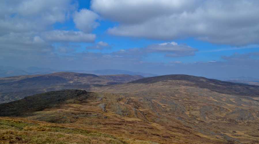
Picture: North Top in shadow, from Knockboy
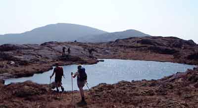
Park at Priests Leap (V98530 61072) , a gravel area next to a commemorative stone for "The Priests Leap" room for 2 cars. There are options for parking also before and after this. Cross the first of many sheepwire fences and make your way to the shores of Lough Boy, here pick up another fence to the north of the lake and follow it to the summit trig and small cairn of Knockboy, drop north of Knockboy to reach the North top. Views of the Shehys to the east, the 'Reeks to the north and the Cahas to the west.
This is a minor northern spur from Knockboy, not really meriting being considered an independent top. This photo is taken from Lough Nambrackdarrig. The highest hill on the skyline is Knockboy, with the North Top being beneath it to the right. Linkback: mountainviews.ie/summit/198/comment/445/
Use of MountainViews is governed by conditions and a privacy policy.
Read general information about the site. Opinions in material here are not necessarily endorsed by MountainViews.
Hillwalking is a risk sport. Information in comments, walks, shared GPS tracks or about starting places may
not be accurate for example as regards safety or access permission. You are responsible for your safety and your permission to walk.
See the credits and list definitions.


 Our Facebook page.