Members and Supporters, the MountainViews Committee requests your help to meet the costs of the website and of other activities such as insured events or publications.
Dunkerron MountainsArea, Cen: An Bheann Mhór
Subarea
Feature count in area: 65, all in Kerry,
OSI/LPS Maps: 78, 83, 84, 85, EW-KNP, EW-R
Highest Place: Stumpa Dúloigh 784m
Starting Places (66) in area Dunkerron Mountains: Ballaghasheen Coilte, Ballaghasheen Pass Viewpoint, Ballaghbeama Gap, Bohacullia, Bridia Valley End, Cahersavane Road, Cahersavane Schoolhouse, Cloon Lough NE, Cloon Lough SE, Coad Cemetery, Coad Road End, Com an Chiste, Coomaclarig Bridge, Coomnahorna River, Coomyanna Bridge, Dereenavurrig, Derreendarragh Church, Derrynane Quay, Dunkerron Mid, Eagles Lough Access Trailhead, Esknaloughoge Forest Trailhead, Fermoyle Farm, Foot Stick Ford Road, Gap of Dunloe Head of, Glashaknockbrassel Stream, Glasheenoultagh Stream, Gortaclohane Lane End, Gortaclohane Lane NE Branch, Gortagowan Wood, Gowlane School Ruin, Gowlanes Wood, Graces Landing, Inchimore West, Isknagahinney Lough E, Kenmare Bridge, Knockanamadane, Knockanaskill N, Knocknasullig, Knocknsallagh Bridge, Laghtacallow, Lissatinnig Bridge Boreen, Looscaunagh Lough W, Lough Barfinnihy CP, Lough Brin S, Lough Coomeen SE, Lough Dromtine NE, Lough Dromtine SE, Lough Fada N, Lough Iskanamacteery N, Lough Iskanamacteery NW, Lough Reagh N, Maghanlawaun Bridia Valley, Molls Gap, Ochtiabh Road, Poulacapple, River Owroe Source, River Sneem Fermoyle Loop, Rossacoosane Mid, Sahaleen Bridge, Scarriff Island, Shamrock Farmhouse B&B, Sneem, Tooreenboy Lough, Tooreennafersha Mid, Tooreennafersha South, Waterville Promenade
Summits & other features in area Dunkerron Mountains: Knocknagantee Near West Top 628m Cen: An Bheann Mhór: An Bheann Mhór 674.7m, An Bhinn Láir 514m, Coomcallee 648.9m, Beann na Stiocairí 673.1m, Coomnahorna 590m, Glanbeg 485.8m, Slievenashaska 578m, Slievenashaska South Top 565.4m Cen: Knocknagantee: Knockmoyle 682.1m, Finnararagh 667m, Cnoc Breasail 591m, Knocknagantee 674.3m, Knocknagantee West Top 553m, Coomnacronia 636m, Coomura Mountain 666m Cen: Mullaghanattin: An Cnoc Riabhach 534m, Beann 752m, Beann Far SW Top 636.2m, Beann NE Top 692m, Beann South Top 639m, Beann SW Top 657m, Sallagh 570m, Mullaghanattin 773m, Mullaghanattin East Top 594m, Sallagh South-West Top 543m E: Kenmare: Gortamullin 205m, Knockanaskill 356m, Letter South 362m N: Knocknacusha: Knocknacusha 547m NE: Knocknabreeda Ridge: Crossderry 489m, Knocknabreeda 569m, Mothaillín 506m NE: Knocknagapple: Bascadh 595m, Bascadh West Top 569m, Boughil 631m, Cnoc na gCapall 639m, Knocklomena 641m NE: Stumpa Dúloigh: Broaghnabinnia 745m, Knockaunanattin 569m, Knockaunanattin West Top 466.1m, Stumpa Dúloigh 784m, Stumpa Dúloigh SE Top 780m, Stumpa Dúloigh SW Top 663m SW: Caherdaniel: Farraniaragh Mountain 468m, Eagle Hill 155m, Reenearagh 162m, Beenarourke 304m, Knocknasullig 117m, Cahernageeha Mountain 498.7m SW: Coad ( Castle Cove ): Beenrour 418m, Eagles Hill 549m, Mullaghbeg 509m SW: Coomduff: Coomduff 244m SW: Deenish: Deenish Island (2) 144m SW: Esknaloughoge: Esknaloughoge 416m, Esknaloughoge North Top 420m SW: Scarriff: Scarriff Island 252m SW: Sneem: An Bheann Mhór 309.3m, Dereenavurrig Hill 261m, Knockanamadane 270m, Knocknafreaghane 316.5m, Knocknagullion 413m SW: Staigue: Staigue Top 459m, Staigue NE Top 435m
Note: this list of places may include island features such as summits, but not
islands as such.
Coomcallee, 648.9mMountain An Ghuala Ghorm A name in Irish,
Place Rating ..
Ir. An Ghuala Ghorm [logainm.ie], 'the blue shoulder’Com Caillí an extra name in Irish, Kerry County in Munster province, in Arderin, Vandeleur-Lynam Lists, An Ghuala Ghorm is the 204th highest place in Ireland.
Grid Reference V62392 67720,
OS 1:50k mapsheet 83 Place visited by: 141members, recently by: Ianhhill, rhw, maoris, ToughSoles, Carolyn105, jackos, Krzysztof_K, mdehantschutter, bryanmccabe, Beti13, conrad1179, NualaB, glencree, Barrington1978, johncusack
I visited this place: NO (You need to be a logged-in member for this.)
Longitude: -9.997518, Latitude: 51.845286, Easting: 62393, Northing: 67720,
Prominence: 100m, Isolation: 1.7km ITM: 462373 567783 Bedrock type: Purple mudstone & siltstone, (Valentia Slate Formation) Notes on name: Also known as Com Caillí [T6000], 'hollow of the hag'. As with other mountain names beginning with coom-, this name has been transferred from a nearby corrie to the summit itself. It is not hard to guess which is the corrie in question as the presence of nearby Lough Coomcallee gives it away. Another Coomcallee is a townland on the north side of Macgillycuddy’s Reeks, though it is now better known by the English translation: The Hag’s Glen.
Short or GPS IDs, 6 char: Cmcl, 10 char: Coomcallee Linkback: https://mountainviews.ie/summit/192/
Gallery for Coomcallee (An Ghuala Ghorm) and surrounds
Summary
for Coomcallee (An Ghuala Ghorm):
Broad summit surrounded by magnificent coums and loughs
Summary created by markmjcampion
2020-11-13 20:39:03
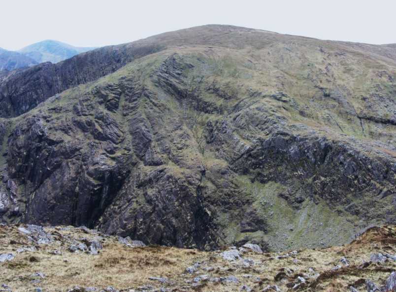
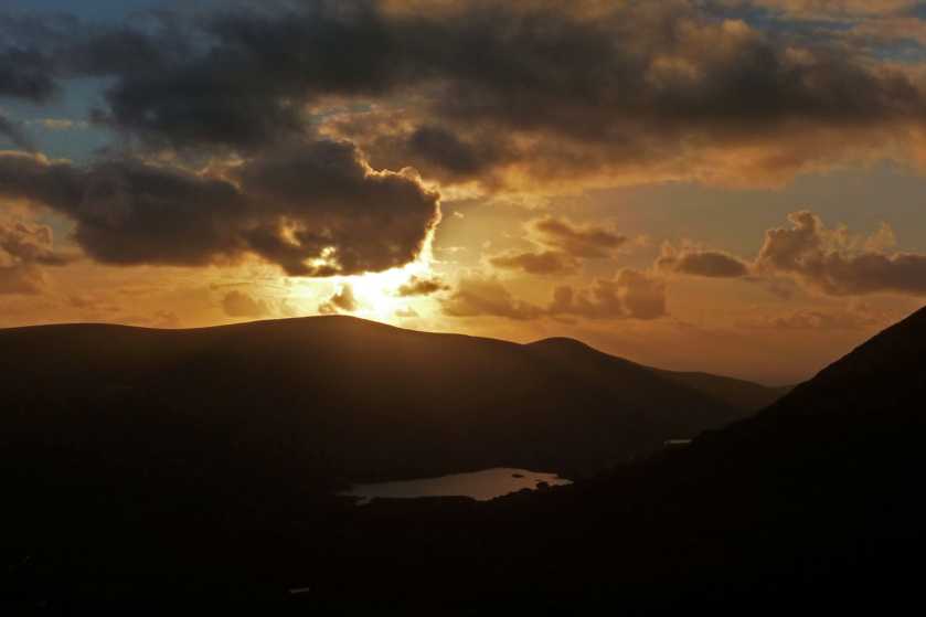
Picture: Coomcallee from the north
Coomcallee is a bulky, steep-sided mountain, situated towards the southern end of the long Iveragh ridge. The main west ridge is fenced so navigation on this side should be ok.
S. From the S drive to Ft Stick (V60267 66312) seeking permission to park. Follow a broad track to A (V60996 68103) A, just 50 metres short of the ridge fence which you can then follow to the summit itself covered in peat hags. Allow around 1.5 hrs to summit - care must be taken in finding the broad track on descent. [see track/3613 for a map]
NW. From the NW park just E of the bridge over the Oveveen River (B (V59676 69799) B). Head back to the bridge, turn right and at C (V60363 69946) leave the road and head uphill to the mound at D (V62168 68916). From here head almost S to E (V60681 68190) and head left along the fence to the summit. 2 hrs +
Track/3566 includes this route but also includes 3 other peaks in a fine circuit.
SW. From the SW park at EsknaTrailhd (V63585 65197) and follow a minor rd and forest track to the W before heading directly for Esknaloughoge and then taking the main Iveragh ridge to the summit [see track/4273]
Track/3406 details the 15k Maughernane Circuit which involves 920m ascent and takes in a lot of interesting, broken ground to the north.
For a much longer walk see track/2495 which is 25.4km long with 1,500m+ ascent.
Views from the top and from vantage pts en route are potentially magnificent both of the nearby peaks, coums and loughs, the coastline and islands of south Kerry and over to Beara..
Commcallee can be very easily ascended from the Glenmore valley to the south west. A tortuous but scenic drive from Waterville ends in a spacious valley. Beyond the last farm (please respect), a broad track can be seen climbing the hillside at an easy gradient. This eventually stops at F (V610 681), just 50 metres short of the ridge fence. The fence passes over point 642, descends 30 metres (the map lacks some contours here) and rises again to the summit, where there are peat hags. Thus the summit can be attained safely in mist. When descending, however, remember that you will not encounter the broad track if you simply walk beside the ridge fence. Furthermore, the track does not start from the lowest point between Coomcallee and L Iskanamacteery Mtn, but from a point 300 metres to the east.
The view is taken from the starting point of the walk, in the direction of point 650. The track is off picture on the green slope on the left. Linkback: mountainviews.ie/summit/192/comment/1748/
Read Less
Read More
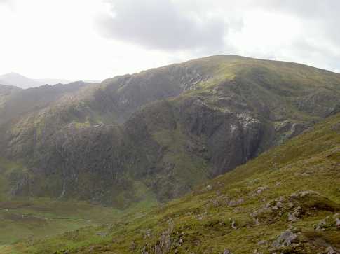
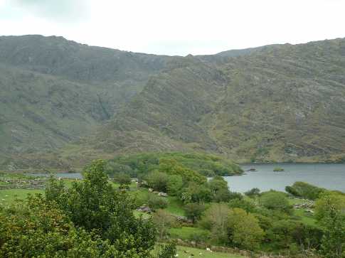
Picture: Looking west to Lough Iskanamacteery from the ascent to Coomcallee
Peter Walker on Coomcallee
by Peter Walker
16 Dec 2008
With my reputation as a guarantee of good weather hanging by a thread, it was a relief that Sunday 14th December granted me a borderline magical trip around Lynam's 'Maughernane Circuit'. The previous few days of precipitation had left a good covering of snow on the ground, but (save for the odd brief bracing shower of hail) I was blessed with bright winter sunshine. I started from just east of the bridge over the Oveveen River (G (V597 698)) where a green strip on the south side of the road is sufficiently substantial to allow a car to park on it without preventing its use as a passing place, before heading off clockwise, preferring to do the smidge of road walking at the start. 'No Trespassing' signs adorn both the fence on the near side of the river and the first dwelling encountered on the right: with that in mind, I went over the next gate after the dwelling, keeping down on the Cloonaghlin Lough side of the shoulder for a few hundred yards, before striking more directly uphill. A track can be picked up (not marked on the map, but obvious on the ground) which eases passage up to about 400m. A steep but straightforward climb leads to an easing at about 500m, before a couple of more gradual steps bring you out on the plateau near point 642m. In the clear weather I had it was easy to skip said point to the east for the final short climb to the top, a great vantage point for this convoluted corner of Iveragh and its glorious coastline. A fence leads WNW from here to continue the circuit. Linkback: mountainviews.ie/summit/192/comment/3478/
Descending in beautiful autumnal light as evening came on, I was lucky to snap this image of the setting sun from the col between Coomcalle and Beann ná Stiocairí, with Lough Isknagahiny in the distance. Ironically, the previous time I'd been in this neighbourhood at the height of summer, I could barely see the hand in front of my face for the mist, I was soaked through and to top it all I fell into a lake! Such are the vagaries of Ireland's climate. Linkback: mountainviews.ie/summit/192/comment/14888/
Read Less
Read More
Picture: Rocky spur viewd across Cloonaghlin Lough
skyehigh on Coomcallee
by skyehigh
12 Jun 2005
There are several interesting ascent options. A purist might ascend via Lough Coomcallee (a gem of a coum) on the east, while the normal ascent from Maughernane (between Lough Iskanamacteery and Cloonaghlin Lough) in the north follows a distinctive curving ridge, also providing spectacular views, to point 642. Rock enthusiasts might like to investigate a rocky spur that abuts the curving ridge - I have no idea how difficult this would be. It starts at H (V619 706).
On top of that, the mountain can be approached along the tortured Iveragh ridge running SSW to NE at this point, or by a simple stroll from Tooreens in the south west. It is wonderfully situated for views, though the flattish summit detracts somewhat. Linkback: mountainviews.ie/summit/192/comment/1747/
Use of MountainViews is governed by conditions and a privacy policy.
Read general information about the site. Opinions in material here are not necessarily endorsed by MountainViews.
Hillwalking is a risk sport. Information in comments, walks, shared GPS tracks or about starting places may
not be accurate for example as regards safety or access permission. You are responsible for your safety and your permission to walk.
See the credits and list definitions.


 Our Facebook page.