Members and Supporters, the MountainViews Committee requests your help to meet the costs of the website and of other activities such as insured events or publications.
Feature count in area: 28, all in Kerry,
OSI/LPS Maps: 78, 79, EW-KNP, EW-R
Highest Place: Mangerton 838.2m
Starting Places (30) in area Mangerton: Cummeenboy Stream, Derrycunihy Church, Dunkerron Mid, Garries Bridge, Gowlane School Ruin, Hidden Valley Pet Farm, Inchimore West, Kenmare Bridge, Killarney Hiking Parking Lot, Knockanaskill N, Knocknsallagh Bridge, Loo River Junction, Looscaunagh Lough W, Lough Barfinnihy CP, Lough Guitane E, Lough Guitane SE, Lough Guitane W, Lynes Farm, Mangerton Walk N CP, Mangerton Walk Start, Molls Gap, Muckross Lake S, Old Rail Level Crossing, Poulacapple, River Roughty, Rossacroo na Loo Forest, Sahaleen Bridge, Shaking Rock W, Shronaboy Farm MTB, Torc Waterfall CP
Summits & other features in area Mangerton: Cen: Dromderlough: Dromderalough 650m, Dromderalough NE Top 654m, Dromderalough NW Top 625m, Knockbrack 610m, Knockrower 554m, Shaking Rock 402m Cen: Inchimore: Inchimore 256m Cen: Mangerton: Glencappul Top 700m, Mangerton 838.2m, Mangerton North Top 782m, Stoompa 705m, Stoompa East Top 608m NE: Crohane: Bennaunmore 454m, Carrigawaddra 425m, Crohane 650m, Crohane SW Top 477m NW: Torc: Cromaglan Mountain 371m, Torc Mountain 534.8m, Torc Mountain West Top 479.4m SE: Esknabrock: Esknabrock 406m SW: Peakeens: Derrygarriff 492m, Derrygarriff West Top 382m, Foardal 409.8m, Knockanaguish 509m, Peakeen Mountain 554.7m, Peakeen Mountain Far NW Top 525.5m, Peakeen Mountain North-West Top 522.7m, Peakeen Mountain West Top 538.7m
Note: this list of places may include island features such as summits, but not
islands as such.
Dromderalough NE Top, 654mMountain Drom idir dhá Loch (mullach thoir thuaidh) A name in Irish,
Place Rating ..
For origin of name, see Dromderalough., Kerry County in Munster province, in Arderin Beg, Vandeleur-Lynam Lists, Dromderalough NE Top is the 190th highest place in Ireland.
Grid Reference V96953 79612,
OS 1:50k mapsheet 78 Place visited by: 109members, recently by: rhw, maoris, Carolineswalsh, SeanPurcell, ToughSoles, Ansarlodge, Krzysztof_K, bagoff, derekfanning, DeirdreM, Taisce, johncusack, SmirkyQuill, eoghancarton, nevgeoran
I visited this place: NO (You need to be a logged-in member for this.)
Longitude: -9.49984, Latitude: 51.960019, Easting: 96953, Northing: 79612,
Prominence: 29m, Isolation: 1.1km ITM: 496923 579722 Bedrock type: Green sandstone & purple siltstone, (Glenflesk Chloritic Sandstone Formation) Notes on name: This peak is slightly higher than Dromderalough itself. Previously Glencappul SE Top in MV.
Short or GPS IDs, 6 char: DrmdNE, 10 char: DrmdrlNETp Linkback: https://mountainviews.ie/summit/183/
Gallery for Dromderalough NE Top (Drom idir dhá Loch (mullach thoir thuaidh)) and surrounds
Summary
for Dromderalough NE Top (Drom idir dhá Loch (mullach thoir thuaidh)):
Long route from the south.
Summary created by Colin Murphy
2019-01-18 14:31:11
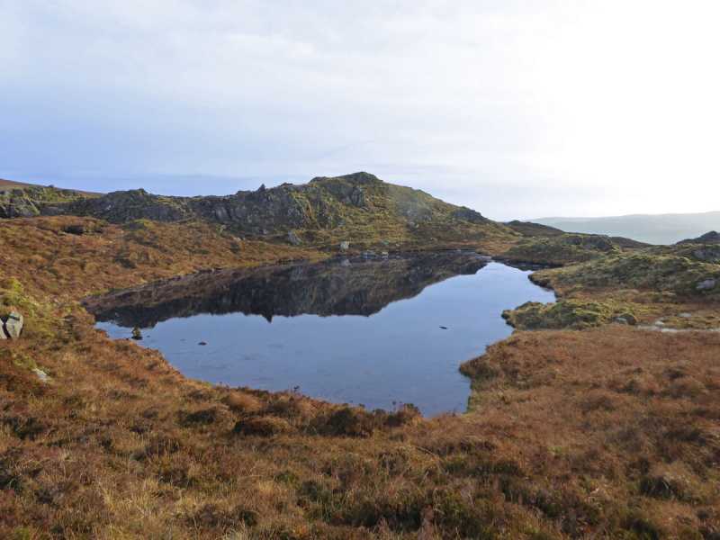
Picture: A tiny, unnamed lough sits just beneath the summit.
Not normally done in isolation, this top usually forms part of a walk involving Dromderalough itself or Mangerton. One approach is from the north, which has the advantage of a gently rising track for most of the journey, but the disadvantage of being a 12km return trip. Park at Mangerton Walk Start (V984 848) and follow the stoney track south for about 4km, which takes you just past the Devil's Punchbowl. Follow a curving route around the southern edge above the lough for about 1km to reach Mangerton summit. For there Dromderalough NE is just over 1km SW, descending to about 620 before the short climb to this not overly distinct top. The terrain on the final part of this trip is quite rough - peat hags, uneven ground, marshy in places. From car to summit took 2.5 hours.
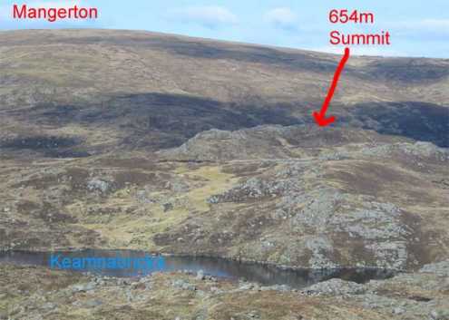
This summit is nothing more than a piece of high ground on your way up to Mangerton from the South-West. It is a bit difficult to pick out as you look at it from Dromderalough although I just happened to get a shadow of a cloud in the right place at the time which shows it in the attached picture.The surrounding area is a bit boggy although as you ascend Mangerton, the going gets easier. The views from it are nice but nothing different from what you will have seen already on your way up to it. The only recommendation I would have for it is that it is a nice spot to stop and catch your breath before you begin the long ascent of Mangerton itself. Linkback: mountainviews.ie/summit/183/comment/2305/
Read Less
Read More
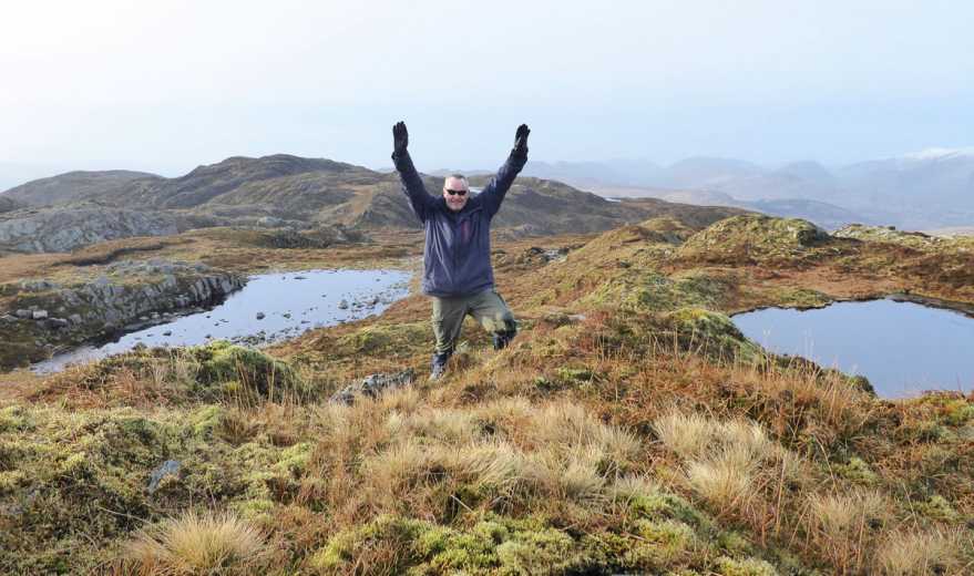
Picture: A minor celebration...
VL Number 273 bagged....
by Colin Murphy
18 Jan 2019
My final Vandeleur-Lynam! Unfortunately No. 273 wasn't the most distinctive summit (when I came off Mangerton I couldn't even pick it out on the landscape) , but the views from the top are tremendous, thanks to the presence of a couple of tiny loughs in the immediate vicinity. Anyway, that's the Arderins. VL's and County Highpoints done. Next up my Local 100! Linkback: mountainviews.ie/summit/183/comment/20339/
Read Less
Read More
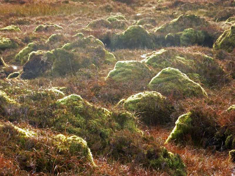
Odd-looking formations
by Colin Murphy
18 Jan 2019
On my approach to the summit I came across a large field of hundreds of these rather striking formations, which I think are are moss-covered boulders, but which looked like giant green ant-hills or some part of a Star Trek set... Linkback: mountainviews.ie/summit/183/comment/20340/
Use of MountainViews is governed by conditions and a privacy policy.
Read general information about the site. Opinions in material here are not necessarily endorsed by MountainViews.
Hillwalking is a risk sport. Information in comments, walks, shared GPS tracks or about starting places may
not be accurate for example as regards safety or access permission. You are responsible for your safety and your permission to walk.
See the credits and list definitions.


 Our Facebook page.