Members and Supporters, the MountainViews Committee requests your help to meet the costs of the website and of other activities such as insured events or publications.
Knockmealdown MountainsArea, Cen: Central Knockmealdowns
Subarea
Feature count in area: 17, by county: Tipperary: 11, Waterford: 11, of which 5 are in both Tipperary and Waterford,
OSI/LPS Maps: 74, 82, EW-K
Highest Place: Knockmealdown 792.4m
Starting Places (16) in area Knockmealdown Mountains: Bay Lough CP, Bay Lough Hairpin, Clogheen South, Crow Hill, Kilballyboy Wood, Kingston Bridge, Knockadullaun, Knockeenanooneen, Knockmeal Mountain Road, Knocksculloge, Liam Lynch Trailhead, Mount Melleray Abbey, R669 Rough Glen River, Spital-Land, Sugar Loaf Horseshoe Viewing Point, The Vee
Summits & other features in area Knockmealdown Mountains: Cen: Central Knockmealdowns: Crohan West 521m, Knockmeal 559.5m, Knockmealdown 792.4m, Knockmoylan 767.1m, Knocknafallia 666.5m, Knocknagnauv 655.1m, Sugarloaf Hill 662.7m E: East Knockmealdowns: Broemountain 430.4m, Knocknanask 486m, Knocknasheega 430.4m, Knocksculloge 432.6m S: Araglin: Knockadullaun 352.2m W: West Knockmealdowns: Crow Hill 516.8m, Farbreaga 518m, Knocknalougha 629m, Knocknalougha South Top 518.6m, Knockshanahullion 653.3m
Note: this list of places may include island features such as summits, but not
islands as such.
Sugarloaf Hill, 662.7mMountain Cnoc na gCloch A name in Irish,
Place Rating ..
(Ir. Cnoc na gCloch [OSI], 'hill of the stones'), Graigue Hill, Tipperary/ Waterford County in Munster province, in Arderin, Vandeleur-Lynam, Irish Highest Hundred Lists, Sugarloaf Hill is the 175th highest place in Ireland. Sugarloaf Hill is the most northerly summit in the Knockmealdown Mountains area.
Grid Reference S03971 10479,
OS 1:50k mapsheet 74 Place visited by: 648members, recently by: kieran117, Ianhhill, rhw, Sophie-Hayes, Deirdreb, BarnabyNutt, taramatthews, orlaithfitz, Carolineswalsh, knightsonhikes, MarionP, Nomad691, jellybean, Tuigamala, ToughSoles
I visited this place: NO (You need to be a logged-in member for this.)
Longitude: -7.942597, Latitude: 52.246504, Easting: 203971, Northing: 110479,
Prominence: 117.7m, Isolation: 2.1km ITM: 603919 610532 Bedrock type: Medium grained pink-purple sandstone, (Knockmealdown Sandstone Formation) Notes on name: The name 'Sugarloaf' is widely applied to hills of a conical shape in Ireland and Britain. Its equivalent 'pain de sucre' is common in France. It is also found further afield, e.g. at Rio de Janeiro in Brazil (Pão de Açúcar in Portuguese) and the Montmorency Falls in Canada, where the name 'Pain de Sucre' is applied to the cone of ice which forms at the base of the waterfall in winter. There is a widespread misconception nowadays that 'sugarloaf' is some kind of bread. In fact, the word refers to the form in which sugar was usually sold all over the world, at least up to the 19th century, until granulated sugar became widely available in packets. The sugary liquid was dripped onto a surface and a solid mass formed in a conical or torpedo-like shape, like a sugary stalagmite. Sugar is still available in this form in North Africa, and it is also used in Germany to make the drink 'Feuerzangenbowle', for which the sugarloaf must first be soaked in rum.
Short or GPS IDs, 6 char: SgrlHl, 10 char: SgrlfHil Linkback: https://mountainviews.ie/summit/170/
Gallery for Sugarloaf Hill (Cnoc na gCloch) and surrounds
Summary
for Sugarloaf Hill (Cnoc na gCloch):
Steep sided hill over looking The Vee and with widespread views
Summary created by markmjcampion, jackill
2023-05-22 13:51:10
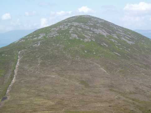
Picture: Sugarloaf Mt. from the SE
Sugarloaf Hill is a v steep roadside hill in the middle of the Knockmealdown range. It lies on the Tipp-Waterford border and provides extensive views of both these counties incl. the Golden Vale, the Comeraghs and the Galtees. It’s quite often met twice in the one day by people looking to summit K’mealdown Mt. itself but can also be summited as part of a circuit.
W. Park in Bay lough carpark Bay Lgh (S03047 09985), cross the road and follow the steep rocky track, keeping the stone wall to your left to the top of the S’loaf. 45min+
N. Start at the Vee A (S04283 11848), where there is lots of room to park safely by the roadside and head up the rough, often boggy track past the Grubb monument (large stone cairn by the roadside) to the summit. Alternatively, you can zigzag up the steep spur as per track/3873. 1hr 15min+
N. A less arduous ascent involves walking to the sharp apex of the Vee itself and following the Munster way (signposted as St. Declan’s way here) down into Glenmoylan. Do not cross the stream but follow the path to the right at B (S04605 11825) going up the glen almost as far as where the non-existent Lough Moylan is shown on OS maps, head up the rocky zig-zag path to the col between the S’loaf and K’mealdown. Cross the col to find the wall and head W to the Sugarloaf. 1.5hrs+
Routes from the S will come via K’mealdown Mt. so best view that page for those routres.
Notable tracks incl. track/2869, circular track/3873, linear track/3480 and the lengthy track/2772.
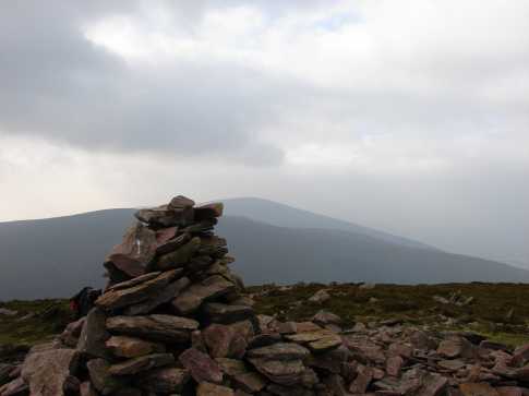
Picture: Knocknalougha and Knockshanahullion from the summit of Sugarloaf Hill.
csd on Sugarloaf Hill
by csd
18 Oct 2006
Parked at the car park marked at The Gap, and headed straight up Sugarloaf Hill. It's a bit of a slog up, and unfortunately parts of the track are showing signs of erosion from walkers. However, as you lift your head on the inevitable stops to catch your breath, the view as you get higher is one of the better ones. It should be possible to make the summit in 40 mins from the car park. Pic shows the view across The Gap to Knocknalougha and Knockshanahullion. Linkback: mountainviews.ie/summit/170/comment/2526/
Read Less
Read More
2 weeks of sunshine, 1 day of cloud!
by paulocon
27 Apr 2010
First time out on the hills in quite some time. A business trip to Tipperary gave me a couple of hours in the morning to bag Sugarloaf Hill. I had planned on climbing Knockmealdown but as I arrived at the Vee Gap, cloud cover meant that visibility was very poor so I parked up beside the grotto and headed up along the county wall behind the Bianconi Hut.
Although quite steep, this is about as easy as it gets - the wall offers a sure guide all the way to the top and there's a very distinct path alongside it. Despite this, I was tempted away from the wall by a path which I assumed offered a more meandering route but which led to a dead end meaning I was forced to contour along some thick rain-sodden heather for my stupidity. A final steep pull leads to the top with the summit cairn being a short distance to the left from the point where the wall turns for Knockmealdown. There is a second cairn a short distance away which I only noticed as it momentarily appeared out of the cloud cover. Although the second cairn is far bigger, I'm pretty sure the first cairn marks the true summit.
Made my way back down and typically the cloud began to move away as I reached the carpark at the Gap. All in all, a handy climb and one that would be suitable for a family walk on a nice summers day. Linkback: mountainviews.ie/summit/170/comment/4667/
Read Less
Read More
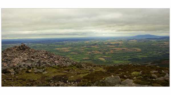
Picture: View from the summit cairn with Slievenamon in the distance
2nd time lucky
by paulocon
28 Sep 2011
2nd time on Sugarloaf and got the views this time! Climbed on 14/09/2011 as the third top of a short Horseshoe walk on the Knockmealdowns. Crossed from Knockmoylan along superb walking ground. Superb views of the Golden Vale and the Galtees from the summit cairn. Descent down to the Gap is over some very steep and eroded ground so care is required. Done a write-up which is at: http://climbingirelandsmountains.blogspot.com/2011/09/evening-in-knocmealdowns.html should anyone be interested. Linkback: mountainviews.ie/summit/170/comment/6538/
Read Less
Read More
jackill on Sugarloaf Hill
by jackill
4 Oct 2004
Looking back on the Sugarloaf along by the county wall towards Knockmoylan.
Knockaunabulloga (overlooking the Vee and Petty Coat Looses favorite hide out Beal Loch) is on the left of photo.An old recitation I can remember my grandfather had said her fist was so big she could crush a man with the weight of it until "Father Power to the Red Sea drove her and gave her a thimble to empty the sea". Linkback: mountainviews.ie/summit/170/comment/1217/
Read Less
Read More
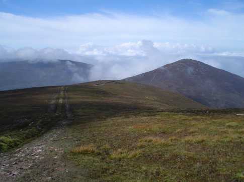
Picture: View down to the carpark from the steep slopes of Sugarloaf Hill
Coming from from the west
by wicklore
23 May 2023
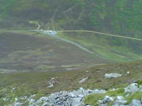
Bank Holiday Monday last was my first trip to the Knockmealdowns. I decided to start with Sugarloaf Hill and make my way across to Knockmealdown and beyond. I am unfamiliar with this area, but using map no.74 I found the carpark on the R668 at Bay Lgh (S03047 09985). Across the road from the carpark a track heads directly up Sugarloaf Hill. This is very steep in places and a punch in the belly after a nearly three hour car journey!
I met an elderly man running down and I proudly told him that I was struggling but making progress. He congratulated me on my ‘fitness’ before informing me he had run up this way earlier, had run across the range and was on his way back. My Hour of Shame! My photo shows the carpark from near the summit of Sugarloaf Hill and gives a sense of the height gained in such a short distance.
The summit arrived surprisingly quickly after about 45 minutes. I was lucky with the weather and had great views in all directions. I spent some time with my maps identifying what I could see in the distance (the Galtees, the Comeraghs) as well as the nearer mountains of the Knockmealdowns themselves.
I then continued on my traverse SW towards Knockmoylan. Linkback: mountainviews.ie/summit/170/comment/3261/
Use of MountainViews is governed by conditions and a privacy policy.
Read general information about the site. Opinions in material here are not necessarily endorsed by MountainViews.
Hillwalking is a risk sport. Information in comments, walks, shared GPS tracks or about starting places may
not be accurate for example as regards safety or access permission. You are responsible for your safety and your permission to walk.
See the credits and list definitions.


 Our Facebook page.