Members and Supporters, the MountainViews Committee requests your help to meet the costs of the website and of other activities such as insured events or publications.
Feature count in area: 65, all in Kerry,
OSI/LPS Maps: 78, 83, 84, 85, EW-KNP, EW-R
Highest Place: Stumpa Dúloigh 784m
Starting Places (66) in area Dunkerron Mountains: Ballaghasheen Coilte, Ballaghasheen Pass Viewpoint, Ballaghbeama Gap, Bohacullia, Bridia Valley End, Cahersavane Road, Cahersavane Schoolhouse, Cloon Lough NE, Cloon Lough SE, Coad Cemetery, Coad Road End, Com an Chiste, Coomaclarig Bridge, Coomnahorna River, Coomyanna Bridge, Dereenavurrig, Derreendarragh Church, Derrynane Quay, Dunkerron Mid, Eagles Lough Access Trailhead, Esknaloughoge Forest Trailhead, Fermoyle Farm, Foot Stick Ford Road, Gap of Dunloe Head of, Glashaknockbrassel Stream, Glasheenoultagh Stream, Gortaclohane Lane End, Gortaclohane Lane NE Branch, Gortagowan Wood, Gowlane School Ruin, Gowlanes Wood, Graces Landing, Inchimore West, Isknagahinney Lough E, Kenmare Bridge, Knockanamadane, Knockanaskill N, Knocknasullig, Knocknsallagh Bridge, Laghtacallow, Lissatinnig Bridge Boreen, Looscaunagh Lough W, Lough Barfinnihy CP, Lough Brin S, Lough Coomeen SE, Lough Dromtine NE, Lough Dromtine SE, Lough Fada N, Lough Iskanamacteery N, Lough Iskanamacteery NW, Lough Reagh N, Maghanlawaun Bridia Valley, Molls Gap, Ochtiabh Road, Poulacapple, River Owroe Source, River Sneem Fermoyle Loop, Rossacoosane Mid, Sahaleen Bridge, Scarriff Island, Shamrock Farmhouse B&B, Sneem, Tooreenboy Lough, Tooreennafersha Mid, Tooreennafersha South, Waterville Promenade
Summits & other features in area Dunkerron Mountains: Knocknagantee Near West Top 628m Cen: An Bheann Mhór: An Bheann Mhór 674.7m, An Bhinn Láir 514m, Coomcallee 648.9m, Beann na Stiocairí 673.1m, Coomnahorna 590m, Glanbeg 485.8m, Slievenashaska 578m, Slievenashaska South Top 565.4m Cen: Knocknagantee: Knockmoyle 682.1m, Finnararagh 667m, Cnoc Breasail 591m, Knocknagantee 674.3m, Knocknagantee West Top 553m, Coomnacronia 636m, Coomura Mountain 666m Cen: Mullaghanattin: An Cnoc Riabhach 534m, Beann 752m, Beann Far SW Top 636.2m, Beann NE Top 692m, Beann South Top 639m, Beann SW Top 657m, Sallagh 570m, Mullaghanattin 773m, Mullaghanattin East Top 594m, Sallagh South-West Top 543m E: Kenmare: Gortamullin 205m, Knockanaskill 356m, Letter South 362m N: Knocknacusha: Knocknacusha 547m NE: Knocknabreeda Ridge: Crossderry 489m, Knocknabreeda 569m, Mothaillín 506m NE: Knocknagapple: Bascadh 595m, Bascadh West Top 569m, Boughil 631m, Cnoc na gCapall 639m, Knocklomena 641m NE: Stumpa Dúloigh: Broaghnabinnia 745m, Knockaunanattin 569m, Knockaunanattin West Top 466.1m, Stumpa Dúloigh 784m, Stumpa Dúloigh SE Top 780m, Stumpa Dúloigh SW Top 663m SW: Caherdaniel: Farraniaragh Mountain 468m, Eagle Hill 155m, Reenearagh 162m, Beenarourke 304m, Knocknasullig 117m, Cahernageeha Mountain 498.7m SW: Coad ( Castle Cove ): Beenrour 418m, Eagles Hill 549m, Mullaghbeg 509m SW: Coomduff: Coomduff 244m SW: Deenish: Deenish Island (2) 144m SW: Esknaloughoge: Esknaloughoge 416m, Esknaloughoge North Top 420m SW: Scarriff: Scarriff Island 252m SW: Sneem: An Bheann Mhór 309.3m, Dereenavurrig Hill 261m, Knockanamadane 270m, Knocknafreaghane 316.5m, Knocknagullion 413m SW: Staigue: Staigue Top 459m, Staigue NE Top 435m
Note: this list of places may include island features such as summits, but not
islands as such.
Coomura Mountain, 666mMountain
Place Rating ..
, Kerry County in Munster province, in Arderin, Vandeleur-Lynam, Irish Best Hundred, Irish Highest Hundred Lists, Coomura Mountain is the 169th highest place in Ireland.
Grid Reference V67722 75178,
OS 1:50k mapsheet 78/83 Place visited by: 125members, recently by: rhw, Nailer1967, knightsonhikes, maoris, abcd, ToughSoles, Krzysztof_K, bryanmccabe, bagoff, Superterence, NualaB, Beti13, Ianhhill, Jai-mckinney, Oscar-mckinney
I visited this place: NO (You need to be a logged-in member for this.)
Longitude: -9.923096, Latitude: 51.913571, Easting: 67722, Northing: 75178,
Prominence: 111m, Isolation: 1.2km ITM: 467701 575240 Bedrock type: Green sandstone & siltstone, (St. Finans Sandstone Formation) Notes on name: Named from nearby coum, where the River Inny rises. The crags at the back of Lough Reagh, dubbed the 'Aiguilles', are remarkably complex and offer many possibilities for climbing.
Short or GPS IDs, 6 char: CmrMnt, 10 char: CmrMntn Linkback: https://mountainviews.ie/summit/162/
Gallery for Coomura Mountain and surrounds
Summary
for Coomura Mountain :
An isolated, rugged peak with stunning flanks and lakes.
Summary created by markmjcampion, Peter Walker
2023-05-19 10:23:23
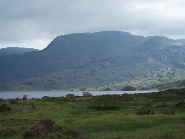
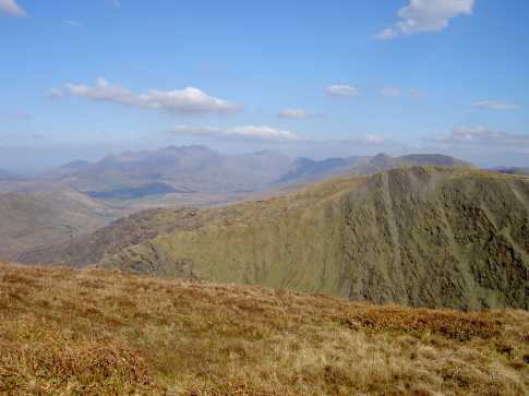
Picture: Coomura Mountain from starting point at Lough Cloon
Teetering on the N edge of the extensive plateau extending N from K'nagantee in the Dunkerrons, Coomura presents v differing forms of complexity depending on viewpoint. Its S frontage is v much knolly and grassy before collapsing into the twisted wonderland around L. Reagh; to the N and E lies a plunging abyss of folds, contortions and benches. Great views abound of the Glenbeigh hills and the peaks of the Iveragh spine.
No timings will be given as they vary wildly depending on terrain and route choice. Suffice to say that most routes demand a lot of care and a long day out.
Coomura is generally visited as part of a longer excursion taking in a selection of summits around the skyline of L. Cloon.
N. The most direct approach starts at the N end of L. Cloon A (V70894 78896) following a track along the W shore before thrashing a way SW up to the col B (V68137 76838) at the foot of the N ridge, which is followed carefully to the grassy summit.
More entertaining and exciting routes can be made through the complex and craggy area around L. Reagh: a sublime area not for the novice or in bad conditions.
W. Start at LisaTin (V64719 75860) and head for K’moyle before swinging around the rim of its NE corrie to Coomura.
SW. Start in the wonderful Coomavoher at ToornBoy (V63144 73905) first taking in K’moyle and K’nagantee.
S. Start at Eagles L (V66910 71221) or Graces (V67715 70864) taking in both those summits plus Coomnacronia. See track/2833
Notable tracks incl. circular track/1969, track/2604 and track/3622.
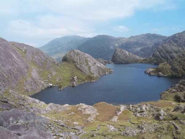
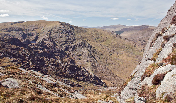
Picture: Above the Lough Reagh Aiguilles - Coomalougha Lake
Lough Cloon to Coomura via Lough Reagh Aiguilles
by ciarraioch
14 Oct 2011
Inspired by Adrian Hendroff's description in his excellent new book 'The Dingle, Iveragh & Beara Peninsulas', we arrived one June morning to do the Lough Cloon Horsehoe. Unfortunately, the cloud refused to co-operate and we thought that we might follow David Herman's ('Hill Walkers Kerry') route into the valley instead (i.e. with a view towards following the initial stages of the former route in an anticlockwise manner if the cloud were to lift later). We parked by the bridge at the northern end of Lough Cloon (C (V708 789)), and initially (10.30) followed the trackway which follows the western shore, and made our way across very rough terrain to the west of Lough Reagh. Eventually we came face to face with the eagerly anticipated aiguilles at the head of the valley. Wow! Waterfalls falling between needle sharp peaks in the most isolated surroundings imaginable. Still following David H's ever trustworthy instruction, we ascended up the most westerly gully, eventually cresting into the Shangri-La of hidden lakes among pinnacles eloquently described by Adrian in his book 'From High Places' . 'Probably' the best mountain scene in the Kingdom! We made our way around the first lake (Coomalougha) but progress was extremely slow due to the roughness of the terrain. It being 15.30, we wisely decided to abandon our initial plan. Instead we made our way south west to an upstream lake from which (D (V681 743)) we headed north west for Coomoura mountain. Grand mountain with decent views and a notably ice scoured northern flank. We found a gully to the right hand side of the line of descent by means of which we managed to avoid most of the rock benches described by other climbers. After seeing an eagle being harried by crows overhead, we rejoined the track to the west of Lough Cloon, to arrive back at our car at 18.10. Nearly 8 hours, but a memorable day. Linkback: mountainviews.ie/summit/162/comment/6565/
Read Less
Read More
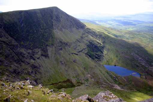
Picture: Knockmoyle from Coomura Mtn
Peter Walker on Coomura Mountain
by Peter Walker
22 Jun 2008
Point A on Simon's Google Earth visualisation...I left my rucksack there for a quick there-and-back up Knockmoyle, and it was something of a relief to find it again! It's that kind of area. If blessed with razor-sharp visibility route-finding is easy hereabouts, but it's all too obvious what a challenge it would be in mist: having walked from Mullaghanattin, I'd intended to go as far as Knocknagantee before turning but fatigue and a burgeoning need for my tea meant I turned north once I reached Coomnacronia. The fences (which are numerous) weren't too much of an obstacle for me with my 34" inside leg measurement: others may not be so lucky. Coomura itself is just a swelling on the edge of the plateau, but highly pleasant for all that. The descent down the shoulder towards Lettergarriv heads towards some excellent views, but is frustratingly slow in places (outcropping rock on the shoulder, thick vegetation once you're off it). Take heed from the experience of this walker: don't assume that because you can see the end of the track by the lough from the shoulder that it's going to be a doddle to get to it on the ground... Linkback: mountainviews.ie/summit/162/comment/3186/
Read Less
Read More
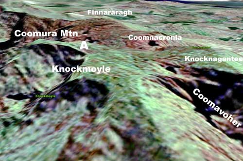
Picture: The boggy plateau.
simon3 on Coomura Mountain
by simon3
20 Sep 2005
Do you like a navigational challenge? Wait for some mist (probably not a long wait), visit Knocknagantee and then walk to Coomura Mtn. It's rough, confusing, boggy land with (as of 2005) lots of high and nasty barbed wire topped fencing. Usually in comments I don't give route hints since I think finding the way is part of the fun. But for this walk, even if you have a GPS, you should particularly study the map. On the Sheet 78 around where it says "Source of the River Inny" look at the contours. Ok that's the hint. It's around point "A" on the Google Earth visualisation. This picture however doesn't give anything remotely like the topographical detail that exists on the ground around point "A". It's quite unlike the usual smooth lip of a coum.
The summit of Coomura probably doesn't get more than a handful of visitors a year. It's nothing exciting -- there's a mini cairn. Linkback: mountainviews.ie/summit/162/comment/1927/
Read Less
Read More
Picture: Coomura Mt
eric on Coomura Mountain
by eric
20 Dec 2005
West side of Coomura Mountain with the Reeks in the background. This photograph is taken from the summit of Knockmoyle. Linkback: mountainviews.ie/summit/162/comment/2109/
Read Less
Read More
Picture: Rough cut sandstone between An Corrán and Coomura.
Coomura's rugged SE flank.
by simon3
26 Apr 2011
Coomura is surrounded by dramatic cliffs and steep ground. From its west is the Coomura valley, a huge corrie with 400m cliffs, to the north the glacier scraped ridge very visible from Knocknacusha, however to the SE there is this dramatic ground with the odd lake. Others have photographed this with varying degrees of success depending on the weather, however I was lucky enough to be on Sallagh in good weather and got this view. Linkback: mountainviews.ie/summit/162/comment/6316/
Use of MountainViews is governed by conditions and a privacy policy.
Read general information about the site. Opinions in material here are not necessarily endorsed by MountainViews.
Hillwalking is a risk sport. Information in comments, walks, shared GPS tracks or about starting places may
not be accurate for example as regards safety or access permission. You are responsible for your safety and your permission to walk.
See the credits and list definitions.


 Our Facebook page.