Members and Supporters, the MountainViews Committee requests your help to meet the costs of the website and of other activities such as insured events or publications.
Knockmealdown MountainsArea, Cen: Central Knockmealdowns
Subarea
Feature count in area: 17, by county: Tipperary: 11, Waterford: 11, of which 5 are in both Tipperary and Waterford,
OSI/LPS Maps: 74, 82, EW-K
Highest Place: Knockmealdown 792.4m
Starting Places (16) in area Knockmealdown Mountains: Bay Lough CP, Bay Lough Hairpin, Clogheen South, Crow Hill, Kilballyboy Wood, Kingston Bridge, Knockadullaun, Knockeenanooneen, Knockmeal Mountain Road, Knocksculloge, Liam Lynch Trailhead, Mount Melleray Abbey, R669 Rough Glen River, Spital-Land, Sugar Loaf Horseshoe Viewing Point, The Vee
Summits & other features in area Knockmealdown Mountains: Cen: Central Knockmealdowns: Crohan West 521m, Knockmeal 559.5m, Knockmealdown 792.4m, Knockmoylan 767.1m, Knocknafallia 666.5m, Knocknagnauv 655.1m, Sugarloaf Hill 662.7m E: East Knockmealdowns: Broemountain 430.4m, Knocknanask 486m, Knocknasheega 430.4m, Knocksculloge 432.6m S: Araglin: Knockadullaun 352.2m W: West Knockmealdowns: Crow Hill 516.8m, Farbreaga 518m, Knocknalougha 629m, Knocknalougha South Top 518.6m, Knockshanahullion 653.3m
Note: this list of places may include island features such as summits, but not
islands as such.
Knocknafallia, 666.5mMountain Cnoc na Faille A name in Irish,
Place Rating ..
(Ir. Cnoc na Faille [LL], (?)'hill of the cliff'), Knocknafalla, Waterford County in Munster province, in Arderin, Vandeleur-Lynam, Irish Highest Hundred Lists, Knocknafallia is the third highest mountain in the Knockmealdown Mountains area and the 167th highest in Ireland.
Grid Reference S09418 07495,
OS 1:50k mapsheet 74 Place visited by: 329members, recently by: Ianhhill, rhw, Petecal423, Carolineswalsh, Leatra, knightsonhikes, ConMack23, Nomad691, jellybean, Tuigamala, ToughSoles, Kaszmirek78, jollyrog, MichaelG55, Moirabourke
I visited this place: NO (You need to be a logged-in member for this.)
Longitude: -7.862922, Latitude: 52.219628, Easting: 209419, Northing: 107496,
Prominence: 153m, Isolation: 1.2km ITM: 609366 607550 Bedrock type: Medium grained pink-purple sandstone, (Knockmealdown Sandstone Formation) Notes on name: ‘Faill’ can be a cliff, but the map indicates no cliff nearby. It can also mean ‘negligence, omission.'
Short or GPS IDs, 6 char: Knc667, 10 char: Kncknfl Linkback: https://mountainviews.ie/summit/158/
Gallery for Knocknafallia (Cnoc na Faille) and surrounds
Summary
for Knocknafallia (Cnoc na Faille):
Boggy, steep-sided flat-top with good views.
Summary created by markmjcampion, jackill
2023-05-14 13:02:31
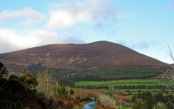
Picture: From the Mellary to Newcastle road
Knocknafallia is a boggy, heathery hill at the E end of the Knockmealdown mts Apart from its NW spur, it’s a v steep-sided mountain - great views of the Comeraghs and all the fine land down to the coast.
E. Park at Knockmeal (S11261 08159) near an abandoned farmhouse - room for 5-6 cars. Take the right-hand of two tracks running parallel uphill and after 0.75 kms follow this track left and around the side of Knockmeal for about 1km to the col at A (S09793 07984). Alternatively, head for the summit of KM and drop down to the same col. From the col slog v steeply uphill to gain the E-W plateau of KNF. 1hr 15m+
If you don’t fancy the steep ascent head W for approx. 1k to ascend via the easier NW spur.
S. Park at Mount Mellary Abbey Melleray (S09825 03923) and follow forest tracks to B (S08266 05771) before heading N to pick up the NW spur of KNF as above. Alternatively, follow the edge of the forest to C (S08824 06310) to summit via the S spur. 2hrs+
SW. Park at Rough Gl (S06473 05148)(room for 4 cars) Head for the top of Dyrick and descend E from here to pick up the previous Mellary route. 2hrs
N. Park at LmLyn Tr (S07985 12121) and follow forest tracks W to the Vee, crossing the gully at D (S04773 12064). Head over Sugarloaf, K’mealdown and K’nagnauv before climbing KNF via its NW spur. 4hrs 20m+ Continue via KN and Crohan W before entering the forest at E (S09611 10867) and taking forestry tracks back to the start. 7hrs+
Notable tracks incl. track/2206, track/3377, the linear track/3243 and the long, circular track/2917
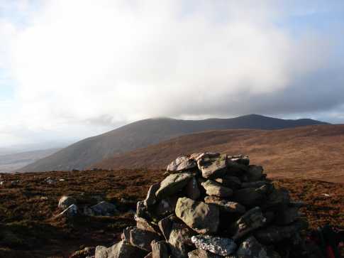
Knocknafallia was the site for a proposed wind farm subject to considerable controversy and ultimate rejection in 1999. The view shows Crohan West (left of picture) and the ridge from it extending to Knockmeal (560m) to the right. Between Knocknafallia and Knockmeal you can see some fairly obtrusive roads associated with the forestry to the right, marked as Meoul on the map. Linkback: mountainviews.ie/summit/158/comment/397/
Read Less
Read More
simon3 on Knocknafallia
by simon3
26 Mar 2003
Knocknafallia has a broad ridge around 500m in length stretching East-West along the top. This fine ruin of a cairn is on the East end of the ridge. It is somewhat hard to say exactly where the summit actually is. The picture shows the cairn and a smaller cairn in the distance. By my reckoning the summit is around 20m South of this smaller cairn. The mountain in the distance is Knockmealdown (794m) with a ridge extending to the right (North) towards Knockmoylan. Linkback: mountainviews.ie/summit/158/comment/398/
Read Less
Read More
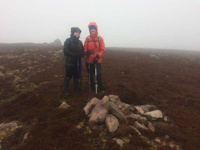
Picture: Not exactly Everest Base Camp
Summit Found
by CaminoPat
28 Jul 2020
Walked to Knocknafallia from Knockmeal on Sunday 18 February to location of stone cairn which includes a passage grave on the eastern side of Knocknafallia. The cairn is located at Irish Grid F (S09418 07495). The elevation of the cairn is 666 metres. Walked west approximately 400 metres to a higher location which has the elevation of 668 metres, as shown on O.S. Map No. 74 for the high point. The coordinates for this new location were recorded and used to correct our position for it. The attached photo shows some members of the Cork Walkie Talkies Club standing next to some stones left by previous walkers at the high point. Linkback: mountainviews.ie/summit/158/comment/19858/
Read Less
Read More
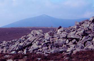
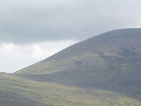
Picture: View over to Knockmealdown and Knockmoylan, from the western cairn.
csd on Knocknafallia
by csd
29 Nov 2006
Coming from Knockmeal, the col between the two mountains takes you down to about 500 metres, so it's a 166 m slog at 45 degrees or worse the rest of the way up to Knocknafallia. I would have to agree with the others regarding the uncertainty of where the true summit of Knocknafallia actually is. The summit location recorded by MV is stout-looking cairn, close to (or at) the spot height marked on the OS map. To my eyes, the ruined cairn (see Simon's pic) looked higher, but I wasn't about to take on a 1 km trek there and back along the boggy summit just to find out! Linkback: mountainviews.ie/summit/158/comment/2568/
Read Less
Read More
Picture: Knocknafallia
mneary34 on Knocknafallia
by mneary34
11 Aug 2005
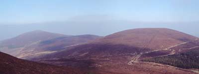
Knocknafallia is a mountain without any definite summit. There is a cairn marked on OS Discovery Series 74 but this is quite clearly not the high point. The attached photo shows the gradient to be tackled between Knockmeal and Knocknafallia. The photo was taken from the northern approach to Knockmeal. See Knocknagnauv for a continuation of the traverse. Linkback: mountainviews.ie/summit/158/comment/1874/
Use of MountainViews is governed by conditions and a privacy policy.
Read general information about the site. Opinions in material here are not necessarily endorsed by MountainViews.
Hillwalking is a risk sport. Information in comments, walks, shared GPS tracks or about starting places may
not be accurate for example as regards safety or access permission. You are responsible for your safety and your permission to walk.
See the credits and list definitions.


 Our Facebook page.