Cookies.
This website uses cookies, which are small text files that the website puts on your device to facilitate operation. Cookies help us provide a better service to you. They are used to track general user traffic information and to help the website function properly.
Features
Nearby features appear when you click the map.
Declutter tracks on map.
Place Search
Video
X
Pub: by
Dublin Area , S: Dublin South East Subarea
Feature count in area: 18, by county: Dublin: 16, Wicklow: 7, Kildare: 1, of which 6 are in both Dublin and Wicklow, OSI/LPS Maps: 43, 50, 56, AWW, EW-DM, EW-WE, EW-WW
Highest Place: Kippure 757m

Starting Places (77) in area Dublin:
Allagour Road, Ballinascorney Golf Club, Ballylerane, Ballylow Bridge, Ballyreagh Wood, Ballyross Forest, Ballysmuttan Long Stone, Barnaslingan Wood, Bohernabreena North CP, Boranaraltry Bridge, Bray Harbour, Cabinteely House, Cannon's Corner, Carrickgollgan, Castelkelly Bridge, Clonkeen Road South, Cloon Wood Cp, Cransillagh Brook , Crone Wood CP, Cruagh Forest Recreation Area, Cruagh Road Hairpin, Curtlestown Wood CP, Dunnes Bank, Enniskerry, Fernhill Estate, Gap Road, Garadhu Road, Glencree Reconciliation, Hell Fire Wood CP, Johnnie Fox Pub, Kilbride Army Camp Entrance, Kilgobbin Lane, Killakee Car Park, Killiney Hill Carpark, Kilmashoge Forest CP, Kilsaran Quarry, Kippure Bridge, Kippure Estate, Kippure Transmitter Gate, Knockbrack, Knockree west, Lackan Wood S, Lamb Doyles, Laughanstown Luas, Lee's Lane, Liffey Bridge, Liffey Head Bridge, Lough Bray Lower, Lough Bray Upper, Lynch's Park Road, Marley Park CP, Novara Avenue, Bray, Old Wicklow Way entrance, Pavilion Theatre, Pine Forest Road, Putland Road, Raheenoon, Rathmichael RC Church, Rathmichael Wood CP, Sally Gap, Sally Gap N, Seahan 265', Seahan 300', Sean Walsh Park, Seefin Trailhead, Shankill Byrnes Bar, Shankill Tributary Bridge, Slademore Road, Sraghoe Brook, St Catherine's Park, The Lamb Hill, The Scalp, Tibradden Forest Recreation Area, Tibradden Lane, Ticknock Forest, Vance's Lane, Wyattville Close

Summits & other features in area Dublin:
N: Howth: Ben of Howth 171m
N: Naul: Knockbrack 176m
S: Dublin South East: Carrickgollogan 275.2m, Glendoo Mountain 585.1m, Killiney Hill 153.5m, Knocknagun 555.3m, Montpelier Hill 383m, Prince William's Seat 553.5m, Tibradden Mountain 466.2m, Two Rock Mountain 536m
S: Kippure & Kilbride: Corrig Mountain 617.1m, Kippure 757m, Seahan 647.3m, Seefin 620.6m, Seefingan 722.9m
S: Saggart: Cupidstown Hill 378.6m, Knockannavea 400.8m, Saggart Hill 396.9m

Note: this list of places may include island features such as summits, but not islands as such.
Rating graphic.
Montpelier Hill, 383m Hill Hellfire Club A name in English,
Place Rating ..
, Dublin County in Leinster province, in Local/Historical/Cultural Lists, Montpelier Hill is the 992nd highest place in Ireland.
Grid Reference O11495 23644, OS 1:50k mapsheet 50
Place visited by: 147 members, recently by: paddyhillsbagger, KateLeckie, glencree, tonio22, Carolineswalsh, nupat, NualaB, Kaszmirek78, CianDavis, Tommer504, abacusms, johncusack, quarryman, miriam, MariaT
I visited this place: NO (You need to be a logged-in member for this.)
Longitude: -6.330326, Latitude: 53.251706, Easting: 311495, Northing: 223644, Prominence: 68m,  Isolation: 3.6km, Has trig pillar
ITM: 711419 723672


  Short or GPS IDs, 6 char: MntpHl, 10 char: MntplrHil

Linkback: https://mountainviews.ie/summit/1507/
Gallery for Montpelier Hill (Hellfire Club) and surrounds
No summary yet for this place .
Member Comments for Montpelier Hill (Hellfire Club)
Comment create / edit display placeholder

            MountainViews.ie picture about Montpelier Hill (Hellfire Club)
Picture: Contemplating the Hellfire Club
The Hellfire Club
by wicklore 11 Aug 2017
The Military Road (R115) runs through the heart of the Dublin/Wicklow Mountains from Rathfarnham to Aughavannagh in deepest Wicklow. The road is 55kms long, and it was constructed between 1800 and 1809 in the wake of the 1798 Rebellion. It was designed to open up the wild Wicklow Mountains to the British army to assist them in reaching the insurgents who were hiding there. A number of military barracks were built along its length which were used to house the soldiers who could rapidly respond when rebels were afoot in the area.

Today the road offers excellent access to the mountains around Glenasmole, Glencree, Sally Gap, Glendasan, Glendalough, Glenmalure and Aughavannagh. It is a great route to see and admire some of the best scenery in Dublin & Wicklow. But besides the mountains and valleys there are many other things of interest along the road that are worth mentioning. From the supernatural to the mythical, the Military Road passes through areas rich in history.

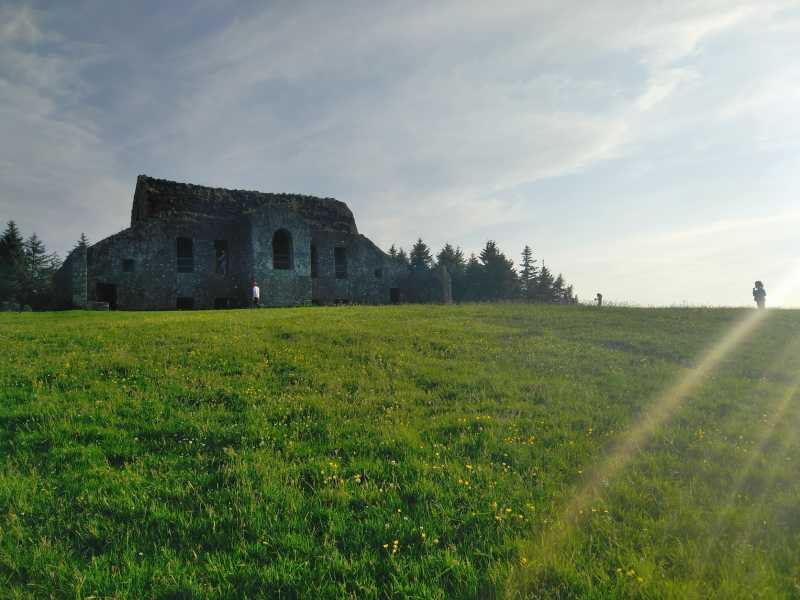
One such curious piece of history is the Hell Fire Club. Shortly after the Military Road begins to rise above Dublin in Rathfarnham, it passes by the Hell Fire Woods car park on the slope of Montpelier Hill. In 1725 a hunting lodge, named Mount Pelier, was built at the summit, using stone from a nearby passage tomb. The destruction of the tomb gave rise to a sense that the building was cursed. Soon after this a storm blew the roof off the building. The roof was rebuilt with more stone and a series of paranormal events were subsequently reported. The central belief was that the Devil was active on the hill and in the lodge. This reputation was further enhanced when members of the Irish Hell Fire Club, which was active in the years 1735 to 1741, began using the lodge as a meeting place. There were many stories of wild behaviour and debauchery as well as occult practices and demonic appearances which added to the local folklore. A recent archaeological dig uncovered some of the original megalithic history of the site.

The Hell Fire Club is still standing, and appears as a hulking stone structure. It is in surprisingly good repair considering it has been abandoned for two centuries. Whatever your beliefs, there are few people who don’t get an eerie feeling in its dark interior. I have personally seen a Rottweiler dog escape from its owner and leap from a first floor window. (Unharmed but raising the hair on the backs of the necks of all who witnessed it). Countless folk will have stories of the eerie feeling encountered in the building. It can be a thrilling place for children to visit with adult supervision.

The views of Dublin and the coast are almost unsurpassed, and Lambay Island, Howth the Mountains of Mourne and Wales can easily be seen on a clear day. This place is visited by 100,000 people a year so go very early or very late if you seek seclusion. Linkback: mountainviews.ie/summit/1507/comment/19674/
Read Less
Read More

            MountainViews.ie picture about Montpelier Hill (Hellfire Club)
Picture: Dublin city with Mourne mountain backdrop
70 Miles as the crow flies
by scannerman 15 Jan 2021
Was planning to climb this little hill last Friday 8th Jan during the snowfall but got called away on a errand but just prior I shot this image of Dublin with the Mourne mountains in the back round roughly 70 miles distant as the crow flies. Linkback: mountainviews.ie/summit/1507/comment/22096/
Read Less
Read More
EDIT Point of Interest
text
Videos


Recent Contributions
x
Conditions and Info
Use of MountainViews is governed by conditions and a privacy policy.
Read general information about the site.
Opinions in material here are not necessarily endorsed by MountainViews.
Hillwalking is a risk sport. Information in comments, walks, shared GPS tracks or about starting places may not be accurate for example as regards safety or access permission. You are responsible for your safety and your permission to walk.
See the credits and list definitions.

OSi logo
OSNI/LPS logo
Open Street Map
(Various variations used.)
British summit data courtesy:
Database of British & Irish Hills