Donation Request 2024

DONATE
Members and Supporters, the MountainViews Committee requests your help to meet the costs of the website and of other activities such as insured events or publications.
You do not have to be logged in to donate.
Features
Nearby features appear when you click the map.
Declutter tracks on map.
Place Search
Video
X
Pub: by
Bluestack Mountains Area , S: Belshade Subarea
Feature count in area: 45, all in Donegal, OSI/LPS Maps: 11, 6
Highest Place: Croaghgorm 674m

Starting Places (22) in area Bluestack Mountains:
An Leathchruach, Barnsmore Gap, Bensons Hill, Caldragh CP, Clogher South peak, Cruach Mhín an Neanta, Doobin, Eanybeg Water Bridge, Edergole Farm, Gaugin Mountain, Glennacree CP, Hillhead, Lough Finn West, Lough Magrath Beg NE, Lough Muck North, Meenaguse Lough, Sand Lough Forest Picnic Area, Scoil Náisúnta an Choimín, Sheskinlubanagh, Sruell Gap Farm, Sruell River Road, St Columbkilles Well and Altar

Summits & other features in area Bluestack Mountains:
Cen: Reelan Hills: Altnapaste 364m, Gaugin Mountain 565m, Lacroagh 403m, Boultypatrick 429m, Croveenananta 476m, Croaghubbrid 416m, Croaghugagh 410m
N: Fintown Hills: Aghla Mountain South Top 589m, Aghla Mountain 593m, Scraigs 426m, Croaghleheen 385m
NW: Glenties: Cloghercor South 301m, Derkbeg Hill 332m, Drumnalough Hill 282m
S: Belshade: Croaghgorm 674m, Croaghgorm South-West Top 597m, Croaghgorm East Top 594m, Ardnageer 642m, Ardnageer SW Top 626m, Banagher Hill 392m, Croaghbane 641m, Croaghgorm Far South-West Top 561m, Cronamuck 444m, Croaghbarnes 498.8m, Glascarns Hill 578.3m, Meenanea 435m
SE: Barnesmore: Brown's Hill 496.4m, Cloghervaddy 402m, Croaghagranagh 440m, Croaghanirwore 546.1m, Croaghbrack 401m, Croaghconnellagh 523m, Croaghnageer 569.1m, Croaghnageer East Top 543.5m, Croaghnageer North-East Top 521m, Croaghonagh 451m
SW: Eany Beg Hills: Binbane 453m, Binbane NE Top 439m, Lavagh Beg 650m, Lavagh More 671m, Binnasruell 505m, Carnaween 521m, Cloghmeen Hill 429m, Silver Hill 600m, Cullaghacro 476m

Note: this list of places may include island features such as summits, but not islands as such.
Rating graphic.
Croaghgorm, 674m Mountain An Chruach Ghorm A name in Irish,
Place Rating ..
(Ir. An Chruach Ghorm [DUPN], 'the blue stack'), Donegal County in Ulster province, in Arderin, Vandeleur-Lynam, Irish Best Hundred, Irish Highest Hundred Lists, An Chruach Ghorm is the highest mountain in the Bluestack Mountains area and the 156th highest in Ireland. An Chruach Ghorm is the third highest point in county Donegal.
Grid Reference G94832 89584, OS 1:50k mapsheet 11
Place visited by: 228 members, recently by: rhw, andalucia, orlaithfitz, Magic, mdehantschutter, ronanmckee, ToughSoles, jimmel567, breathp, garybuz, Paddym99, michaelseaver, ochils_trekker, Krzysztof_K, Alanjm
I visited this place: NO (You need to be a logged-in member for this.)
Longitude: -8.081078, Latitude: 54.754162, Easting: 194832, Northing: 389584, Prominence: 541m,  Isolation: 0.9km, Has trig pillar
ITM: 594780 889575
Bedrock type: Quartz & feldspar pebbles, green matrix, (Lough Mourne Formation)
Notes on name: Situated in the townland of Sruell. Marked as Bluestack on 1st series of 6 maps. Locally the range is simply known as na Cruacha or the Crows.
  Short or GPS IDs, 6 char: Crghgr, 10 char: Croaghgorm

Linkback: https://mountainviews.ie/summit/150/
Gallery for Croaghgorm (An Chruach Ghorm) and surrounds
Summary for Croaghgorm (An Chruach Ghorm): Isolated high point of the Bluestacks with spectacular views
Summary created by markmjcampion, Colin Murphy 2021-05-03 21:05:24
            MountainViews.ie picture about Croaghgorm (<em>An Chruach Ghorm</em>)
Picture: Croaghgorm from Binnasruell
Croaghgorm is a remote, rocky mt. which is part a few loops. A new bulldozed track has opened it up for those pushed for time but for those eschewing this track be ready for a long, tough walk. Great views abound as a reward incl. the Sligo/Leitrim hills and much of S and mid Donegal.

NE. Park at Clogher S (G95937 94109), walk 50m east and then turn S on a lane not shown on the MV map. After approx. 200m take a left, cross the Reelan river and soon turn S either a) for the top of Glascarns Hill via its NW spur or b) to follow the river topping out at Croaghbane after a long, steep pull. Whatever you do, you will summit Croaghbane from where you head W for a rocky, undulating but pleasant walk to Ardnageer. Head SW to Ardnageer SW top. Croaghgorm lies 1.5km to the SW, with a relatively gentle ascent across a rock/grass mixture. Allow 3hrs+

SW. Park with permission at Sruell Gp (G92039 88718). Either a) follow the new bulldozed track up to A (G93950 90442) and then swing steeply SE to reach Croaghgorm or b) head 1st for C Far SW top [it's a steep slog and it's less steep to start 1km SW of the farm]. It's a short down and up to the SW top and, from the next col, a steep pull up to C.

S. Park at Sand L Fst (G95353 86632) having navigated a rough road for 2km. Head NNE up an obvious spur to B (G95648 88215) and then over to C (G96278 88672) from where it's a steep slog up to C E top. Go N for about 100m and then roughly W for 1.5km to reach C.

Notable tracks incl. track/3801, track/3177 and track/3106.
Linkback: mountainviews.ie/summit/150/comment/4910/
Member Comments for Croaghgorm (An Chruach Ghorm)
Comment create / edit display placeholder

            MountainViews.ie picture about Croaghgorm (<em>An Chruach Ghorm</em>)
Picture: Looking towards the Derryveagh range from Croaghgorm summit
eflanaga on Croaghgorm
by eflanaga 11 Jun 2006
From Binnasruell summit (See fro previous part of circuit) I took a bearing of 93E to take me in direction of the saddle above Sruell Gap passed earlier in the day prior to climbing Croaghbane. The terrain was not as difficult on this side of the valley as it had been when crossing from Lavagh Beg to ‘Sruell. I decided to veer slightly of course so as to come around the southern end of Spot Height 465m ID (G92524 90443). This took me along the heights above Sruell Gap with wonderful views up and down the valley and across to Croaghgorm. Aided by sheep tracks managed to maintain reasonable height. Decided to drop down to floor of gap short of the saddle as I could see what appeared to be relatively straightforward route up SW slope of the hill. Grassy slopes for tmost part, eventually reaching height before drop into gully then steep climb up rockier ground to wonderfully broad summit IE (G94834 89585). Fantastic views in every direction. This is really a beautiful mountain. Stopped for a while hunkered down in the shade of the small stone shelter with what appears to be a ‘water hydrant metal lid’ in it! What’s that about? While there heard the noise of an engine. Looking over rim of shelter I saw a tractor with man and child on lower slopes below. My wave was returned in a friendly manner and the man got on with his business, while I got on with mine, which was to take the easiest route possible over roughly 5k back to camp site on Croaghbarnes IF (G99067 90066). Decided to take a bearing of 76NE and make for Binmore above Lough Belshade and then drop on to the saddle between Croaghbarnes and Croaghbane, On the way passed some of the wreckage of aircraft mentioned by gerrym. Initial part of descent was over exposed slab and boulder & was relatively easy. However, once I passed below Binmore I realised that things were not going to work out as easy as I thought. Was faced with a series of very deep gullys, which spilled their contents into the beautiful Belshade lough below. While the exposed rock made for steady footing I was faced with ‘cliff like’ drops in places necessitating a degree of ‘switchback’ in order to reach slopes of Croaghbarnes. Making the saddle was not an option so had to drop to within 100m of lough & struggle over deep tussock grass and gorse before I could eventually begin final ascent of the day up to camp site. Once I had decamped and removed all trace of my presence I had the long slog with heavy pack on tired legs over 3K over difficult terrain following course of Corabber river to start of Edergole track IG (G97840 88071) and the car a further 2K beyond. Despite difficulties encountered in latter part of Croaghgorm to Croaghbarnes stage (not recommended), entire route, was extremely challenging but enjoyable. Summiting Croaghgorm was a cause for celebration in itself as it marked my 100th summit over 500m since I started on July 4th last year with Errigal. Linkback: mountainviews.ie/summit/150/comment/2393/
Read Less
Read More

            MountainViews.ie picture about Croaghgorm (<em>An Chruach Ghorm</em>)
Picture: The track
The magic highway
by wicklore 29 Mar 2021
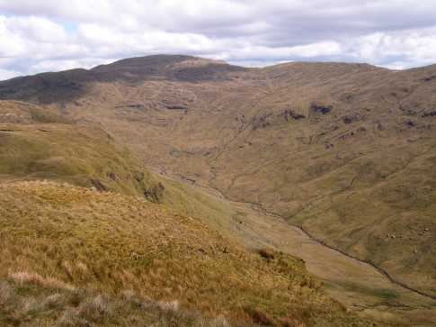
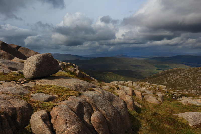
In days of yore there was an article about the Bluestacks in the now deceased Walking World Ireland magazine. It featured a photo of a wild landscape and included adjectives such as ‘lonely’, ‘remote’ & ‘rough.’ Many MV posts on the various Bluestack summits echo this language. It was not until very recently that I finally set foot in this rugged upland area.

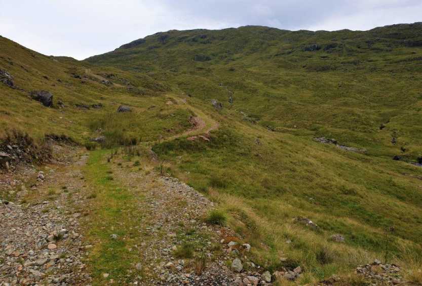
My first walk was a tiring there-and-back route from Glashcarns to Croaghgorm East Top. When I reached the distinctive quartz mound west of Ardnageer SW Top I got a great view up to the col between Croaghgorm and Lavagh More. And there I spied a track that wasn’t shown on my old OSI map. It meandered over the col from the SW and along the northern slopes of Croaghgorm. As one who gets excited at new discoveries, I saw the possibility of this being an easy access route to Croaghgorm for my next day’s hiking.

The next morning I was able to park at Sruell Gp (G92092 88644) after speaking to the lady at the farm. I went through two gates and along a muddy track that petered out into the fields after a few hundred meters. Further on at H (G92723 89483) it suddenly re-emerged as a much more substantial stone track. The track continued along the valley and led up (very steeply at times) to the aforementioned col and beyond. A junction at 
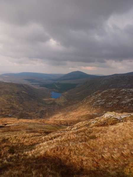
I (G94148 90343) led to the vicinity of the small lake near the summit area where the track ended. It took just over an hour to access these upper reaches. The track reappeared after the summit and meandered past the summit areas of both Croaghgorm South-West & Far South-West Tops before leading down to the farmhouse where I had parked earlier.

Finding this full-circuit ‘magic highway’ was a bittersweet feeling. It facilitated a much easier and quicker exploration of the Croaghgorms, which was a welcome respite after the exertions of the previous day. But it evoked memories of remote Slieve Carr in Mayo which was subjected to the scrutiny of those trying to find the quickest route using newly developed forest tracks. Encroaching tracks eroded the remoteness of Slieve Carr. While the Croaghgorm track gives similar easy access to a remote and rugged area, it also removes some of the thrill of remote hiking.

I subsequently discovered Peter Walker had already described this ‘manky great new bulldozed track’ in walk number 3106. So while I had stumbled upon the track through my own rambling, I was actually following in the footsteps of giants!

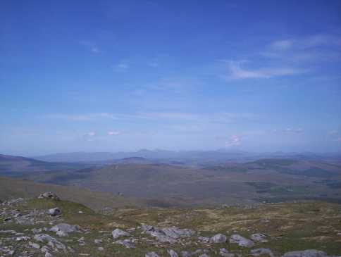
The upshot of all of this is that there is, for better or worse, an easy way to reach the col between the two Bluestack giants of Lavagh More and Croaghgorm. This will suit those who are tight for time or who are too tired or unable for a tougher route. It also illustrates the value in reading not just summit comments but also articles that accompany gps tracks that have been posted on MV. But do this research before you travel, and not in a car miles from the nearest cell tower! Linkback: mountainviews.ie/summit/150/comment/20646/
Read Less
Read More

            MountainViews.ie picture about Croaghgorm (<em>An Chruach Ghorm</em>)
Waterfalls and great views
by tiktiktik3 3 May 2021
Bluestacks - Binmore-(Groaghgorm) 29/08/2005
Ordnance Survey Discovery Series map 11

We started out from Donegal Town direction Bluestacks/Letterkenny (N15). On the first signpost Bluestacks Way (mapgrid 79/95) turn left towards Harvey’s point (Lough Eske) (mapgrid82/96), continue on the road round the lough. When you come on the far point of the Lough (mapgrid 86/96) you wil see a small road going up the mountain. Follow it until you see a sign “private road” and a fence next to it where there’s a parking spot to leave your car. Now go on foot through the fence and follow the road until it peters out into a path. One point of interest : almost at its end you will see a little stream coming down the mountain - follow your ears and you’ll find a magnificent waterfall, the water falls down in a deep gully with a black pool at the bottom. If you follow the goats down (it's real easy) you'll be rewarded mid-stream with a beautiful spot on some big boulders in front of the fall for a rest or a picnic before the actual climb
Once your on the move again, a little further the track ends and you have to find your own way up. We chose to go by the first gully ahead and that route seemed ok - other ways are possible. Once on top we steered toward Binmore, through a valley of bog who takes up some time to work (find) your way through. Noted there are three little lakes (mapgrid 88/96). Once you reach Binmore things are easier again (no more bog). It’s a nice climb with nice views as more and more of the Bluestack range reveals itself, while behind you in good weather great views of Lough Esk and Ben Bulbin open up. As you get to the top of Binmore on your right you will see a giant’s footstep (mapgrid 89/97) - I think Finn Mac Cool who built the Giant Causeway made a stroll inland at one point. The moment I saw it I named it Lough Foot. Once on top you'll find a sheltering cairn big enough to put one or two small tents if you're prepared for it and plan to stay overnight. For me and my wife this was as high as we got Although we wanted to stay a few hours longer exploring and push on over the ridge to Croaghgorm, time was against us going way past over 19:00 so it was wise to head back down during the daylight that was left - all in all a more than recommended walk/climb.
Next time I will try not to linger that long by the waterfall… Linkback: mountainviews.ie/summit/150/comment/1956/
Read Less
Read More

            MountainViews.ie picture about Croaghgorm (<em>An Chruach Ghorm</em>)
Picture: The Reelan Valley from the eastern slope.
Extensive Mountain Not Fully Explored Yet.
by Aidy 19 Aug 2014
I have had a lot of pleasure walking in the Bluestacks, and Croaghgorm, the highest in the range had long been on my list. I had previously climbed Croaghbane, but hadn't been able to continue along the rest of the ridge due to the weather, so I set off on the same route again, on this occasion just missing Croagbane's summit, and approaching Croaghgorm on a great walk via Ardnageer and Ardnageer SW Top. The top is marked by a stone shelter cairn, which I was grateful for as the weather had turned windy and cold by the time I got there, and I was able to rest the legs in relative comfort.

Croaghgorm is a broad lump of a mountain, and I would have loved to take the time to to explore the extensive ground to the southeast and east towards Lough Belshade, and to the south west. However, I had a long walk already done, and still wanted to visit Lavagh More and Lavagh Beg, before another long walk back to the car in the Reelan Valley. I think I will come back another day, maybe taking a more direct route to Croaghgorm by itself to do it justice. Due to the lack of time, I also couldn't find any trace of the World War 2 plane wreckage, and I would like more time to find that too. For now though, it was on to Lavagh More. The photo was taken on the way up the east side. Linkback: mountainviews.ie/summit/150/comment/17627/
Read Less
Read More

            MountainViews.ie picture about Croaghgorm (<em>An Chruach Ghorm</em>)
Picture: Croaghnard Valley in the evening light
Painful descent via Croachanard Lough
by Colin Murphy 29 Mar 2014
Having spent over three hours reaching this isolated summit from the Reelan River bridge at J (G963 937), rather than re-trace my steps, I decided I could save considerable time and enjoy better views by returning via the wonderful Croaghanard Lough Valley. There is a forest to the north of the lough in which I could see a distinct track (visible in picture). I descended into the valley which was surprisingly firm underfoot, keeping to the east of the numerous streams. There is enough space between the forest and lough to allow for relatively easy walking. All went well until I was just to the north of the lough and only 100m from the forest track - the only problem was that there was no access to the track! After searching around for 15 minutes, I realised I would have to take the plunge and battle through the densely packed woodland. I finally emerged on to the track after 20 minutes of cursing, crawling, fighting and beating my way through unbending branches! The track led me directly back to my car as it happened, and saved me over an hour's journey. But was it worth it? Scratched, bruised, leggings shredded! If you decide to take this route, bring a machete! Linkback: mountainviews.ie/summit/150/comment/15953/
Read Less
Read More
EDIT Point of Interest
text
Videos


Recent Contributions
x
Conditions and Info
Use of MountainViews is governed by conditions and a privacy policy.
Read general information about the site.
Opinions in material here are not necessarily endorsed by MountainViews.
Hillwalking is a risk sport. Information in comments, walks, shared GPS tracks or about starting places may not be accurate for example as regards safety or access permission. You are responsible for your safety and your permission to walk.
See the credits and list definitions.

OSi logo
OSNI/LPS logo
Open Street Map
(Various variations used.)
British summit data courtesy:
Database of British & Irish Hills