Members and Supporters, the MountainViews Committee requests your help to meet the costs of the website and of other activities such as insured events or publications.
Feature count in area: 34, all in Galway,
OSI/LPS Maps: 37, 44, EW-CON, MSW
Highest Place: Benbaun 729m
Starting Places (48) in area Twelve Bens: Angler's Return, Barr na nÓran Road, Ben Lettery Hostel, Bogville Road, Bridge St Clifden, Bundorragha Estuary Cross, Bunnageeha, Cannaclossaun, Connemara Mountain Hostel, Connemara National Park Visitor Centre, Dernasliggaun, Doire na bhFlann North, Doughruagh CP, Emlaghdauroe Bridge, Emlaghdauroe South, Fee Lough SW, Foher, Glasbeg Stream, Glashmore Bridge, Glencoaghan River Bridge, Glencraff Road End, Gleninagh River, Illaunroe North, Illaunroe South, Inaghbeg Path, Kylemore Abbey Exit, Kylemore River, Letterfrack Lodge, Lettergesh Beach, Lough Anivan Bend, Lough Auna S, Lough Fee East, Lough Nacarrigeen S, Lough Tanny, Muck Lough NW, Nambrackkeagh Lough, Owen na Baunoge River, Owengar Bridge, Owenglin River, Owenwee River, Pollacappul Lough E, Pollacappul Lough W, Shanvally, Skeaghatimull, Ten Bens Cottage, Tooreennacoona River, Western Way Cnoc na hUilleann, Western Way Inagh Cottages
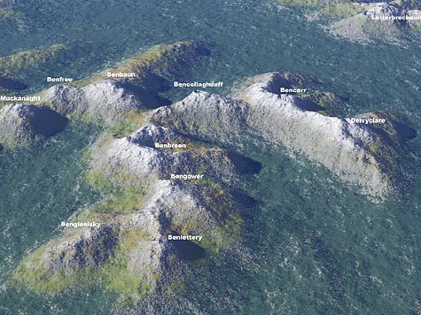
Summits & other features in area Twelve Bens: Cen: Lough Auna Hills: Cregg 297m, Townaloughra East Top 216m Cen: Polladirk: Bencullagh 632m, Maumonght SW Top 454m, Diamond Hill 442m, Knockbrack 442m, Maumonght 602m E: Glencorbet: Benbaun 729m, Benbrack 582m, Benbaun 477m, Knockpasheemore 412m, Benfree 638m, Muckanaght 654m N: Doughruagh: Altnagaighera 549m, Benchoona 581m, Benchoona East Top 585m, Currywongaun 273m, Doughruagh 526m, Doughruagh South Top 525m, Garraun 598m, Garraun South Top 556m, Letterettrin 333m SE: Glencoaghan Loop: Bencollaghduff 696m, Benglenisky 516m, Benlettery 577m, Bencorr 711m, Bencorr North Top 690m, Bencorrbeg 577m, Binn an tSaighdiúra 653m, Benbreen 691m, Benbreen Central Top 680m, Benbreen North Top 674m, Derryclare 677m, Bengower 664m
Note: this list of places may include island features such as summits, but not
islands as such.
Derryclare, 677mMountain Binn Doire Chláir A name in Irish,
Place Rating ..
(Ir. Binn Doire Chláir [TR], 'peak of Derryclare'), Galway County in Connacht province, in Arderin, Vandeleur-Lynam, Irish Best Hundred, Irish Highest Hundred Lists, Binn Doire Chláir is the 151st highest place in Ireland. Binn Doire Chláir is the second most easterly summit in the Twelve Bens area.
Grid Reference L81509 51048,
OS 1:50k mapsheet 37 Place visited by: 448members, recently by: rhw, DeirdreM, BarnabyNutt, taramatthews, Daingean, Juanita, CaminoPat, orlaithfitz, PiotrR, maoris, Prem, Carolineswalsh, miriam, Tuigamala, abptraining
I visited this place: NO (You need to be a logged-in member for this.)
Longitude: -9.785748, Latitude: 53.496315, Easting: 81509, Northing: 251048,
Prominence: 129m, Isolation: 1.2km ITM: 481516 751074 Bedrock type: Pale quartzites, grits, graphitic top, (Bennabeola Quartzite Formation) Notes on name: Ir. clár can mean both a plain and a board. In the latter sense it can refer to a plank-bridge in some place-names. Thus Derryclare, from Ir. Doire Chláir, could either mean 'oak-wood of the plain' or 'oak-wood of the plank-bridge'. The name seems to have been transferred by the Ordnance Survey from the townland of Derryclare situated to the east to the mountain itself. In this respect the Ir. name Binn Doire Chláir makes much more sense as a mountain name.
Short or GPS IDs, 6 char: Dryclr, 10 char: Derryclare Linkback: https://mountainviews.ie/summit/146/
Gallery for Derryclare (Binn Doire Chláir) and surrounds
Summary
for Derryclare (Binn Doire Chláir):
One of Conemara's finest - a rocky, bulky mountain with great views.
Summary created by markmjcampion, Colin Murphy, wicklore
2023-05-10 12:19:35
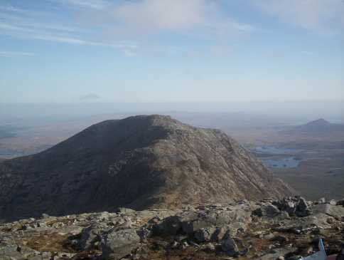
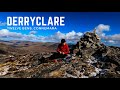
Picture: Derryclare from the South
One of the 12 Bens, Derryclare with its distinctive sharp S ridge is a majestic mt and is part of both the Glencoaghan Horseshoe and the 12 Bens Challenge. It commands a fine view of nearby valleys, the Maamturks, Mayo hills and the myriad lakes and smaller hills of S Connemara. It’s formed from quartzite and its upper slopes are comprised of shattered rock that require care to negotiate esp. on descent.
SW. There is room for a few cars at A (L80558 48957). Head E over varied pastures, picking your way up the S ridge. The ascent to the summit becomes a steep haul but there is a fairly obvious trail most of the way. It climbs initially over peat and heather before attaining the rock of the upper reaches. Particular care is required in the initial steep section above the pastures as a few crags and rock outcrops are negotiated. Also keep to the E of the ridge to stay well clear of sharp drops and plunging cliffs. A number of false summits are passed before the small pile of rocks that mark the summit are reached. 1.5 hrs
E. Park on Coillte forest track at CmaraMtn Hst (L84552 49923). Continue along track which loops around Derryclare Lough and take another track to the right at B (L83478 50412) which leads to open ground. Go 1km north across gently sloping ground and then ascend W up a steep, but climbable grassy and rocky spur. Terrain flattens out somewhat as you approach summit. A delightful ascent. 2 hrs+
Notable tracks incl. track/3248, track/1283 and track/2731.
Having negotiated the peaks of Binn Gabhar, Binn Bhraoín, Binn Dubh and Binn Chorr the nine Mid-Ulster walking club members undertaking the Glencoaghan Horseshoe walk made their weary way down the 160+ metres of the south-eastern face of Binn Chorr to the col below Binn Doire Chláir C (L81248 51827) at 550m. This left a final climb of some 120 metres passing a locheen on the way to the summit cairn, which would represent the final climb of the day. Another member of the club, who had a watch, which monitored our ascent throughout the day, was able to calculate that we had climbed some 1640m throughout the course of the Horseshoe walk. The walk itself was completed in glorious sunshine with the views from each of the peaks spectacular. Binn Doire Chláir was no exception. In the evening sunlight and to the east the Mamturks range lay invitingly. To the south-east Derryclare Lough was just one of many dotting the plains below, likewise to the west until blocked by the solid masses of Binn Leitirí, Binn Gabhar & Binn Ghleann Uisce. After reaching the summit there remained the long walk along Binn Doire Chláir’s southern spur until eventually we climbed laboriously down into the Glencoaghan valley near Bennaderreen Rock D (L81304 49547). On reaching the valley floor we re-joined the lane/road to the west and walked the 2K, or so, back to where the cars were parked. The entire walk took about 10 hours. It could be completed in less time, say around 8 to 8.5 hours by fit aand experienced walkers but as a walking club it is always important to maintain a pace, which suits all members. From my point of view this was one of the most enjoyable walks I have ever completed – fantastic weather, great company and above all spectacular scenery makes the Glencoaghan Horseshoe a must for serious hill walkers. Linkback: mountainviews.ie/summit/146/comment/2331/
Read Less
Read More
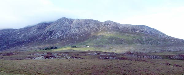
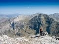
Picture: Derryclare-BenCorr-BenCorrBeg
CaptainVertigo on Derryclare
by CaptainVertigo
5 Aug 2005
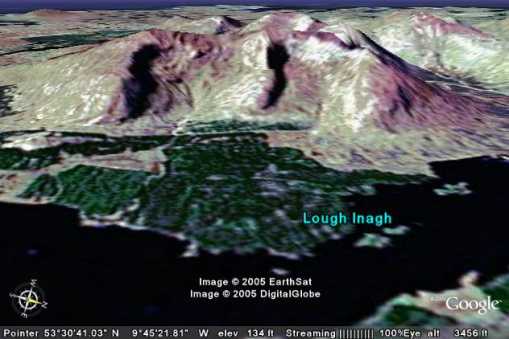
This "snapshot" taken from Google Earth shows the Derryclare-BenCorr-BenCorrBeg peaks from a height of 3500 feet approx (looking westward from the Maamturks over Lough Inagh). I like the sense of 3 dimensionality. The two huge corries (I presume that's what they are) are particularly noticeable. The crucial fact about Google-Earth is that you can "fly" at any height you want , and as you move your viewpoint the features of the mountains are thrown into relief. I regularly annoy fellow climbers by reminding them we must live now, so we'll have something to remember in our nursing homes. My hope is that by the time I reach my penultimate resting place, Google Earth will have progressed to the point that virtual climbing will be possible, with total surround sense-o-rama to include wind, clouds, the smell of the heather,the flavour of hot tomato soup on a freezing peak, and possibly a member of the nubility murmuring Yes...Yess...Yess...Joyce's Country indeed!! Linkback: mountainviews.ie/summit/146/comment/1857/
Read Less
Read More
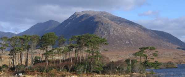
Picture: From the Clifden road
aburden on Derryclare
by aburden
27 Feb 2006
Coming from Binn Corr towards the end of the Chochan Circuit the walk up to Doire Chlair is a tough series of false summits. From the top there is a long walk down past another series of false "anti-summits". At about 330m (E (L81388 49581)) I crossed a sheep trail (running East to West) which I joined and weaved through the last of the rocks and crags and finally reached valley floor. My car was parked about 1½ km from here – completing the Chochan Circuit. 13Km, 6.5hr Includes c.30mins of stops and excludes the cost of a new pair of knees ! Linkback: mountainviews.ie/summit/146/comment/2211/
Read Less
Read More
simon3 on Derryclare
by simon3
11 Jun 2004
The mountain is also known as Derryclare and is the start of a popular circuit of the southern Bens variously known as the Derryclare Horseshoe, The Benlettery Horseshoe or the Glencoaghan Circuit.
Ascending the mountain is fairly straightforward. Stick to near the ridge. My memory of the walk when I first did it in the early 70’s was of a series of false summits. These are visible on the map and in the photo. Around the middle of the ascent there is one particularly distinct false summit -- see skyline just right of centre on the photo. On old 1 inch OS maps there is a feature named as “Lop Rock”, which perhaps is this place. Linkback: mountainviews.ie/summit/146/comment/986/
Use of MountainViews is governed by conditions and a privacy policy.
Read general information about the site. Opinions in material here are not necessarily endorsed by MountainViews.
Hillwalking is a risk sport. Information in comments, walks, shared GPS tracks or about starting places may
not be accurate for example as regards safety or access permission. You are responsible for your safety and your permission to walk.
See the credits and list definitions.


 Our Facebook page.