Members and Supporters, the MountainViews Committee requests your help to meet the costs of the website and of other activities such as insured events or publications.
Dunkerron MountainsArea, Cen: An Bheann Mhór
Subarea
Feature count in area: 65, all in Kerry,
OSI/LPS Maps: 78, 83, 84, 85, EW-KNP, EW-R
Highest Place: Stumpa Dúloigh 784m
Starting Places (66) in area Dunkerron Mountains: Ballaghasheen Coilte, Ballaghasheen Pass Viewpoint, Ballaghbeama Gap, Bohacullia, Bridia Valley End, Cahersavane Road, Cahersavane Schoolhouse, Cloon Lough NE, Cloon Lough SE, Coad Cemetery, Coad Road End, Com an Chiste, Coomaclarig Bridge, Coomnahorna River, Coomyanna Bridge, Dereenavurrig, Derreendarragh Church, Derrynane Quay, Dunkerron Mid, Eagles Lough Access Trailhead, Esknaloughoge Forest Trailhead, Fermoyle Farm, Foot Stick Ford Road, Gap of Dunloe Head of, Glashaknockbrassel Stream, Glasheenoultagh Stream, Gortaclohane Lane End, Gortaclohane Lane NE Branch, Gortagowan Wood, Gowlane School Ruin, Gowlanes Wood, Graces Landing, Inchimore West, Isknagahinney Lough E, Kenmare Bridge, Knockanamadane, Knockanaskill N, Knocknasullig, Knocknsallagh Bridge, Laghtacallow, Lissatinnig Bridge Boreen, Looscaunagh Lough W, Lough Barfinnihy CP, Lough Brin S, Lough Coomeen SE, Lough Dromtine NE, Lough Dromtine SE, Lough Fada N, Lough Iskanamacteery N, Lough Iskanamacteery NW, Lough Reagh N, Maghanlawaun Bridia Valley, Molls Gap, Ochtiabh Road, Poulacapple, River Owroe Source, River Sneem Fermoyle Loop, Rossacoosane Mid, Sahaleen Bridge, Scarriff Island, Shamrock Farmhouse B&B, Sneem, Tooreenboy Lough, Tooreennafersha Mid, Tooreennafersha South, Waterville Promenade
Summits & other features in area Dunkerron Mountains: Knocknagantee Near West Top 628m Cen: An Bheann Mhór: An Bheann Mhór 674.7m, An Bhinn Láir 514m, Coomcallee 648.9m, Beann na Stiocairí 673.1m, Coomnahorna 590m, Glanbeg 485.8m, Slievenashaska 578m, Slievenashaska South Top 565.4m Cen: Knocknagantee: Knockmoyle 682.1m, Finnararagh 667m, Cnoc Breasail 591m, Knocknagantee 674.3m, Knocknagantee West Top 553m, Coomnacronia 636m, Coomura Mountain 666m Cen: Mullaghanattin: An Cnoc Riabhach 534m, Beann 752m, Beann Far SW Top 636.2m, Beann NE Top 692m, Beann South Top 639m, Beann SW Top 657m, Sallagh 570m, Mullaghanattin 773m, Mullaghanattin East Top 594m, Sallagh South-West Top 543m E: Kenmare: Gortamullin 205m, Knockanaskill 356m, Letter South 362m N: Knocknacusha: Knocknacusha 547m NE: Knocknabreeda Ridge: Crossderry 489m, Knocknabreeda 569m, Mothaillín 506m NE: Knocknagapple: Bascadh 595m, Bascadh West Top 569m, Boughil 631m, Cnoc na gCapall 639m, Knocklomena 641m NE: Stumpa Dúloigh: Broaghnabinnia 745m, Knockaunanattin 569m, Knockaunanattin West Top 466.1m, Stumpa Dúloigh 784m, Stumpa Dúloigh SE Top 780m, Stumpa Dúloigh SW Top 663m SW: Caherdaniel: Farraniaragh Mountain 468m, Eagle Hill 155m, Reenearagh 162m, Beenarourke 304m, Knocknasullig 117m, Cahernageeha Mountain 498.7m SW: Coad ( Castle Cove ): Beenrour 418m, Eagles Hill 549m, Mullaghbeg 509m SW: Coomduff: Coomduff 244m SW: Deenish: Deenish Island (2) 144m SW: Esknaloughoge: Esknaloughoge 416m, Esknaloughoge North Top 420m SW: Scarriff: Scarriff Island 252m SW: Sneem: An Bheann Mhór 309.3m, Dereenavurrig Hill 261m, Knockanamadane 270m, Knocknafreaghane 316.5m, Knocknagullion 413m SW: Staigue: Staigue Top 459m, Staigue NE Top 435m
Note: this list of places may include island features such as summits, but not
islands as such.
Slievenashaska South Top, 565.4mMountain Sliabh na Seasca (mullach theas) A name in Irish,
Place Rating ..
For origin of name, see Sliabh na Seasca / Slievenashaska., Kerry County in Munster province, in Arderin Lists, Sliabh na Seasca (mullach theas) is the 376th highest place in Ireland.
Grid Reference V64346 69911,
OS 1:50k mapsheet 84 Place visited by: 37members, recently by: maoris, Carolyn105, chelman7, muddyboots, annem, osullivanm, simon3, eamonoc, Fergalh, peter1, eoghancarton, Wilderness, Grumbler, FrankMc1964, Ulsterpooka
I visited this place: NO (You need to be a logged-in member for this.)
Longitude: -9.970047, Latitude: 51.865445, Easting: 64347, Northing: 69911,
Prominence: 36m, Isolation: 0.9km ITM: 464326 569974 Bedrock type: Green sandstone & siltstone, (St. Finans Sandstone Formation) Notes on name: previously known on MV as Coomcathcun South Top
Short or GPS IDs, 6 char: SlvnSt, 10 char: SlvnshSthT Linkback: https://mountainviews.ie/summit/1424/
Gallery for Slievenashaska South Top (Sliabh na Seasca (mullach theas)) and surrounds
Summary
for Slievenashaska South Top (Sliabh na Seasca (mullach theas)):
Fine ridge peak amongst wild land and lakes.
Summary created by simon3, Colin Murphy
2018-06-14 07:24:05
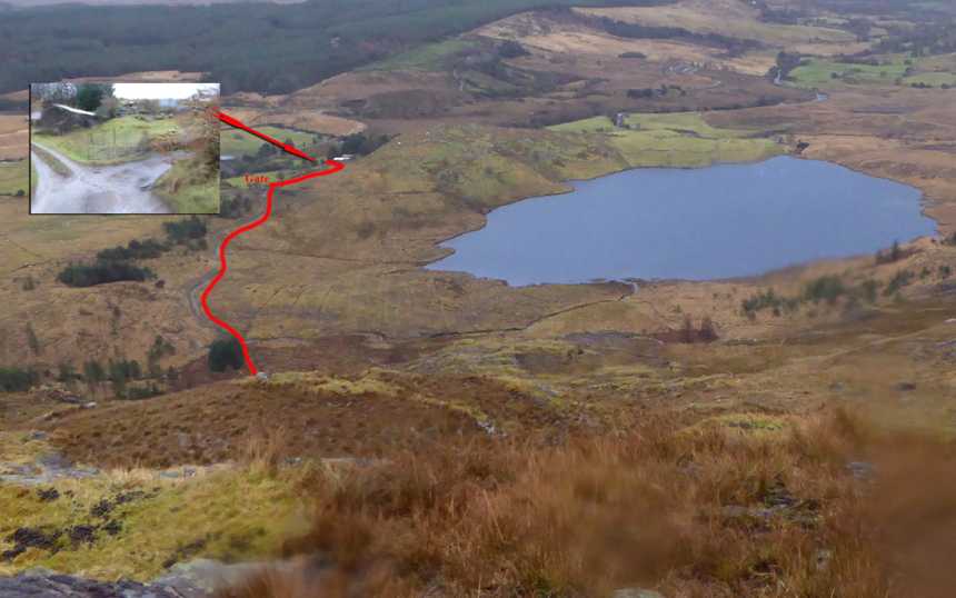
Picture: Route to open hillside
This is normally done in conjunction with Coomcathcun, but may also be completed in isolation. Take the road to the NW of Sneem (following the Sneem River), turning left at point A (V672 698) and following the narrow road around to the left until it terminates beside a farmhouse. Ask permission here for access and parking (as of Feb 2016 the elderly farmer has no objection to walkers, but won't allow dogs).
Continue on foot past the farmhouse, swinging to the right almost immediately before old stone building. (See pic inset). Follow this track for about 100m until you come to a gate. Do not continue through gate. Instead, on the left is a muddy sheep pen and behind it, very easy to miss, is a track that curves to the north of Dromtine Lough (in red on pic).
Follow this track, crossing the shallow stream and you will then emerge on open mountainside. Proceed directly west over grassy, steepish terrain. You will need to veer to south or north slightly to pass some steep rock outcrops, after which the incline eases. Continue over several humps for about 1.5km then turn south at point B (V644 705). Continue for 500m over mostly rocky/grassy surface to reach the summit, which is marked by a pile of stones. From car to summit to car took 4 hours, although conditions were very poor.
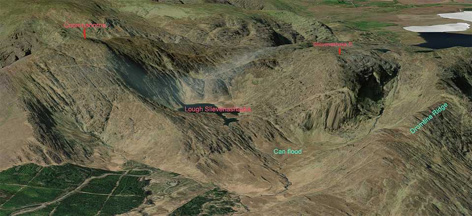
See comments under Coomnahorna for details of horseshoe route (Coomahorna, Slieveshaska South & Slieveshaska). Lovely rock-bound lakes to the west of the summit. Massive strata twisted and buckled. Slow going over rough ground. Amazing country. Linkback: mountainviews.ie/summit/1424/comment/19944/
Read Less
Read More
Picture: Summit stones
Walls of rock
by Colin Murphy
29 Feb 2016
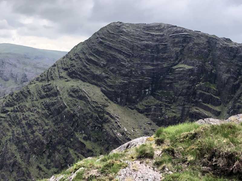
This is a very rare new addition to the Arderin list and would normally be done in conjunction with Coomcathcun or Coomnahorna and Coomcallee from the south, but if you've already bagged those and missed this one, then it's possible to do it on its own, and with relative ease, from the east. Unfortunately, the day we did it, the rain, wind and cold were unrelentingly cruel! This slowed our ascent considerably (multiple slippages), although overall, the terrain is pretty solid and not too steep. See short summary for access, directions etc. The mountain's aspect from the ridge to the NE is very impressive - a gigantic wall of precipitous rock, with Slievenashaska Lough nestling to the mountain's equally steep south face. The final 500m as you turn south offers multiple, pretty loughs amid a terrain of rock and grass. The summit is marked by a largish pile of rocks and overlooks the lough to the south. Overall, a very worthy Arderin. Linkback: mountainviews.ie/summit/1424/comment/18446/
Use of MountainViews is governed by conditions and a privacy policy.
Read general information about the site. Opinions in material here are not necessarily endorsed by MountainViews.
Hillwalking is a risk sport. Information in comments, walks, shared GPS tracks or about starting places may
not be accurate for example as regards safety or access permission. You are responsible for your safety and your permission to walk.
See the credits and list definitions.


 Our Facebook page.