Members and Supporters, the MountainViews Committee requests your help to meet the costs of the website and of other activities such as insured events or publications.
Feature count in area: 19, all in Mayo,
OSI/LPS Maps: 22, 23, EW-WNN
Highest Place: Maumakeogh 379m
Starting Places (9) in area North Mayo: Bangor Trail Head, Carnhill, Carrowmore Wood, Erris Head, Portacloy Bay, Proesoon, Sralagagh West, Termon Hill Road, Tower Hill South
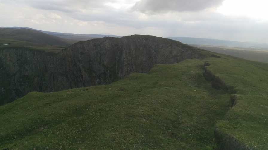
Summits & other features in area North Mayo: Cen: Pulathomas: Barnacuillew 260m E: Ballycastle Hills: Knockaghaleague 237m, Knockboha 186m, Maumakeogh 379m N: Benwee Head Cliffs: Benwee Head 255m, Barradeegin 229m, Glinsk 304m, Illanmaster 238m, Illanmaster Island 105m, Porturlin Hill 155m, Srahataggle 182m, Tawnaghmore 340m S: Bangor Erris Hills: Carrafull 269m, Knocklettercuss 370m, Knocknascollop NW Top 244m, Sheean 295m, Slieve Fyagh 335m W: Belmullet: Aghaglasheen 132m, Termon Hill 103m
Note: this list of places may include island features such as summits, but not
islands as such.
Porturlin Hill, 155mHill
Place Rating ..
, Mayo County in Connacht province, in Binnion Lists, Porturlin Hill is the 1466th highest place in Ireland.
Grid Reference F89682 42421,
OS 1:50k mapsheet 23 Place visited by: 10members, recently by: Wilderness, gerrym, justynagru, Fergalh, IainT, sandman, IncaHoots, Garmin, barrymayo, chalky
I visited this place: NO (You need to be a logged-in member for this.)
Longitude: -9.696049, Latitude: 54.318597, Easting: 89682, Northing: 342421,
Prominence: 122m, Isolation: 2.2km ITM: 489656 842422 Bedrock type: Psammites with rare heavy mineral bands., (Benmore Formation)
Short or GPS IDs, 6 char: PrtrHl, 10 char: PrtrlnHil Linkback: https://mountainviews.ie/summit/1341/
The local name for this hill according to the locals is Tiabh Mor so who am i to disagree . The hill can be the start or finish of a fantastic coastal walk. Parking at A (F89089 42078) will allow quick access to open common. The views at the summit are truly great but do be careful as one wrong step will have you discussing the advantages of flight with a seagull on the way down. Linkback: mountainviews.ie/summit/1341/comment/18557/
Use of MountainViews is governed by conditions and a privacy policy.
Read general information about the site. Opinions in material here are not necessarily endorsed by MountainViews.
Hillwalking is a risk sport. Information in comments, walks, shared GPS tracks or about starting places may
not be accurate for example as regards safety or access permission. You are responsible for your safety and your permission to walk.
See the credits and list definitions.


 Our Facebook page.