Members and Supporters, the MountainViews Committee requests your help to meet the costs of the website and of other activities such as insured events or publications.
Feature count in area: 65, all in Kerry,
OSI/LPS Maps: 78, 83, 84, 85, EW-KNP, EW-R
Highest Place: Stumpa Dúloigh 784m
Starting Places (66) in area Dunkerron Mountains: Ballaghasheen Coilte, Ballaghasheen Pass Viewpoint, Ballaghbeama Gap, Bohacullia, Bridia Valley End, Cahersavane Road, Cahersavane Schoolhouse, Cloon Lough NE, Cloon Lough SE, Coad Cemetery, Coad Road End, Com an Chiste, Coomaclarig Bridge, Coomnahorna River, Coomyanna Bridge, Dereenavurrig, Derreendarragh Church, Derrynane Quay, Dunkerron Mid, Eagles Lough Access Trailhead, Esknaloughoge Forest Trailhead, Fermoyle Farm, Foot Stick Ford Road, Gap of Dunloe Head of, Glashaknockbrassel Stream, Glasheenoultagh Stream, Gortaclohane Lane End, Gortaclohane Lane NE Branch, Gortagowan Wood, Gowlane School Ruin, Gowlanes Wood, Graces Landing, Inchimore West, Isknagahinney Lough E, Kenmare Bridge, Knockanamadane, Knockanaskill N, Knocknasullig, Knocknsallagh Bridge, Laghtacallow, Lissatinnig Bridge Boreen, Looscaunagh Lough W, Lough Barfinnihy CP, Lough Brin S, Lough Coomeen SE, Lough Dromtine NE, Lough Dromtine SE, Lough Fada N, Lough Iskanamacteery N, Lough Iskanamacteery NW, Lough Reagh N, Maghanlawaun Bridia Valley, Molls Gap, Ochtiabh Road, Poulacapple, River Owroe Source, River Sneem Fermoyle Loop, Rossacoosane Mid, Sahaleen Bridge, Scarriff Island, Shamrock Farmhouse B&B, Sneem, Tooreenboy Lough, Tooreennafersha Mid, Tooreennafersha South, Waterville Promenade
Summits & other features in area Dunkerron Mountains: Knocknagantee Near West Top 628m Cen: An Bheann Mhór: An Bheann Mhór 674.7m, An Bhinn Láir 514m, Coomcallee 648.9m, Beann na Stiocairí 673.1m, Coomnahorna 590m, Glanbeg 485.8m, Slievenashaska 578m, Slievenashaska South Top 565.4m Cen: Knocknagantee: Knockmoyle 682.1m, Finnararagh 667m, Cnoc Breasail 591m, Knocknagantee 674.3m, Knocknagantee West Top 553m, Coomnacronia 636m, Coomura Mountain 666m Cen: Mullaghanattin: An Cnoc Riabhach 534m, Beann 752m, Beann Far SW Top 636.2m, Beann NE Top 692m, Beann South Top 639m, Beann SW Top 657m, Sallagh 570m, Mullaghanattin 773m, Mullaghanattin East Top 594m, Sallagh South-West Top 543m E: Kenmare: Gortamullin 205m, Knockanaskill 356m, Letter South 362m N: Knocknacusha: Knocknacusha 547m NE: Knocknabreeda Ridge: Crossderry 489m, Knocknabreeda 569m, Mothaillín 506m NE: Knocknagapple: Bascadh 595m, Bascadh West Top 569m, Boughil 631m, Cnoc na gCapall 639m, Knocklomena 641m NE: Stumpa Dúloigh: Broaghnabinnia 745m, Knockaunanattin 569m, Knockaunanattin West Top 466.1m, Stumpa Dúloigh 784m, Stumpa Dúloigh SE Top 780m, Stumpa Dúloigh SW Top 663m SW: Caherdaniel: Farraniaragh Mountain 468m, Eagle Hill 155m, Reenearagh 162m, Beenarourke 304m, Knocknasullig 117m, Cahernageeha Mountain 498.7m SW: Coad ( Castle Cove ): Beenrour 418m, Eagles Hill 549m, Mullaghbeg 509m SW: Coomduff: Coomduff 244m SW: Deenish: Deenish Island (2) 144m SW: Esknaloughoge: Esknaloughoge 416m, Esknaloughoge North Top 420m SW: Scarriff: Scarriff Island 252m SW: Sneem: An Bheann Mhór 309.3m, Dereenavurrig Hill 261m, Knockanamadane 270m, Knocknafreaghane 316.5m, Knocknagullion 413m SW: Staigue: Staigue Top 459m, Staigue NE Top 435m
Note: this list of places may include island features such as summits, but not
islands as such.
Knockmoyle, 682.1mMountain An Cnoc Maol A name in Irish,
Place Rating ..
(prob. Ir. An Cnoc Maol [PDT], 'bald or round hill'), Kerry County in Munster province, in Arderin, Vandeleur-Lynam, Irish Highest Hundred Lists, An Cnoc Maol is the 139th highest place in Ireland.
Grid Reference V66511 74978,
OS 1:50k mapsheet 78/83 Place visited by: 133members, recently by: rhw, Nailer1967, knightsonhikes, maoris, abcd, ToughSoles, Krzysztof_K, bryanmccabe, bagoff, NualaB, glencree, Beti13, Ianhhill, Jai-mckinney, Oscar-mckinney
I visited this place: NO (You need to be a logged-in member for this.)
Longitude: -9.940593, Latitude: 51.911485, Easting: 66512, Northing: 74979,
Prominence: 169m, Isolation: 1.2km ITM: 466491 575040 Bedrock type: Green sandstone & siltstone, (St. Finans Sandstone Formation) Notes on name: Overlooks the valley of Coomura. The name was recorded in 1845 as Cruckmweel with the approval of T.E. Larcom (Lieutenant Thomas Larcom of Royal Engineers, in charge of the Ordnance Survey in Ireland) and then given a standardised anglicisation as Knockmoyle by John O’Donovan, the renowned Gaelic scholar who was later appointed Professor of Celtic Languages at Queen’s College, Belfast. The Irish name for this peak is given as Eisc an Ghalláin at logainm.ie, citing the aerial map in Ó Cíobháin’s Toponomia Hiberniae III. However, this name means ‘ravine of the standing stone’ and is marked on O’Cíobháin’s own map as a ravine leading up to this peak, not as a name of the peak itself, which is unnamed on the map.
Short or GPS IDs, 6 char: Knc682, 10 char: Knockmoyle Linkback: https://mountainviews.ie/summit/131/
Gallery for Knockmoyle (An Cnoc Maol) and surrounds
Summary
for Knockmoyle (An Cnoc Maol):
Highpoint of the plateau east of Coomavoher
Summary created by markmjcampion, Onzy
2021-03-31 14:46:52
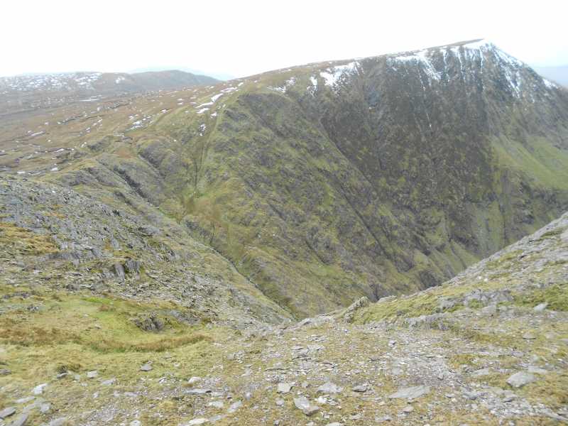
Picture: Knockmoyle from lower slopes of Coomura Mountain
Knockmoyle in mid Iveragh, close to the Glencar-Waterville road, may have an uninspiring summit but it more than makes up for this with its surrounding coums and loughs, in particular the gem that is Coomavoher. It's worth the long drive just to walk in this coum alone! And you are very likely to be alone! It also overlooks Coomura to the NE and is home to some staggering views over this desolate part of Iveragh as well as further afield to the Glenbeigh hills and Knocknadobar.
NW. For the most direct route park with care at LisaTin (V64723 75805). Head E along the track that veers SE after a km and heads steeply up into Knockmoyle's western coum. Aim for the knoll at A (V66209 74570) after which there is a much gentler route to the summit. Allow 1.5hrs+
W. Park with permission at around V6B (V3155 7389) from where a circuit of Coomavoher itself, taking in K'moyle and K'nagantee, as well as any, or all of, Cnoc Breasail, Coomura and Coomnacronia is possible. This is a long walk and to take in all the tops allow circa 8 hours.
From this starting point it is also possible to walk into Coomavoher [a sublime experience!] and to ascend v steeply either N or S from approx. C (V65203 73867).
S. Park either at Eagles L (V66909 71220) or D (V67473 70636). There is a fine circuit of Eagle's Lough taking in Knocknagantee and Coomnacronia which can extended to take in both K'moyle and Coomura Mt. Allow around 5 hours
Notable tracks incl. track/3224, track/1969, track/3622 and track/4409.
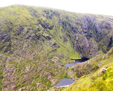
Picture: Lakes at the head of Coomavoher under Knockmoyle
simon3 on Knockmoyle
by simon3
20 Dec 2005
Come SW over the Ballaghisheen Pass and you can see Knockmoyle very clearly (well, assuming you can see anything of course). Knockmoyle is just the NW corner of a high plateau, which it shares with Coomura Mtn and Knocknagantee. After I visited the place on a day with the cloud down I really wasn't surprised to read later in Richard Mersey [The Hills of Cork and Kerry] that "A little further north I did my most desolate walk one winter: that was the circuit of Coomavoher." Later he says of Knockmoyle "This is quite a respectable looking peak from the north, but it is a featureless bog from the south: no place to be in mist." I would completely agree though on a modern note I would also mention that there is a particularly unpleasant variety of high barbed wire fence there also.
The Coomavoher valley rises West to East just to the south of Knockmoyle having no less than 5 lakes. (There's a sixth pond in line with the others and even higher which arguably should be included.). The picture was taken from the southern side of Coomavoher near pt 553 on the 1:50k. The two lakes are numbers 3 and 4 in height order. Actually number 5 is visible high on the extreme right - it was much clearer in the original picture. I couldn't see the "slender thread of waterfall which issues from it" as extolled by David Herman [Hillwalkers Kerry] which was a pity. The summit on the skyline is Knockmoyle and the ridge to the right leads to Knocknagantee. What remote lakes, what a fantastic wild valley! Linkback: mountainviews.ie/summit/131/comment/1925/
Use of MountainViews is governed by conditions and a privacy policy.
Read general information about the site. Opinions in material here are not necessarily endorsed by MountainViews.
Hillwalking is a risk sport. Information in comments, walks, shared GPS tracks or about starting places may
not be accurate for example as regards safety or access permission. You are responsible for your safety and your permission to walk.
See the credits and list definitions.


 Our Facebook page.