Members and Supporters, the MountainViews Committee requests your help to meet the costs of the website and of other activities such as insured events or publications.
Summits & other features in area North East Midlands: Cen: Ballyjamesduff: Aghalion Hill 249m Cen: Oldcastle: Mullaghmeen 258m, Slieve Na Calliagh 276m, Spire of Lloyd 131m, The Hill of Mael 241m E: Kingscourt: Carrickleck Hill 173m N Cen: Cavan Town: Shantemon 218m, Slieve Glah 320m, Tievenanass 261m NE: Ballybay: Bunnanimma 268m NE: Carrickmacross: Corduff 243m NE: Castleblaney: Mullyash Mountain 317m NE: Cen Bailieborough: Cornasaus 339m, Taghart South 290m NW Cen: Arva: Bruse Hill 260m NW: Aughavas: Lugganammer 190m S Cen: Crookedwood: Cruckboeltane 199m, Knockeyon 214m S: Westmeath South West: Knockastia 200m SE: Boyne Valley: Hill of Slane 160.4m, Mount Oriel 251m, Tara 155m W: Ardagh: Bawn Mountain 200m W: Drumlish: Corn Hill 278m
Note: this list of places may include island features such as summits, but not
islands as such.
Cruckboeltane, 199mHill
Place Rating ..
, Westmeath County in Leinster province, in Binnion Lists, Cruckboeltane is the 1402th highest place in Ireland.
Grid Reference N43300 62300,
OS 1:50k mapsheet 41 Place visited by: 10members, recently by: melohara, ceadeile, conormcbandon, jackill, chalky, eamonoc, sandman, paddyhillsbagger, Fergalh, wicklore
I visited this place: NO (You need to be a logged-in member for this.)
We visited this summit in June but found the field mentioned by Fergalh to be sown with a cereal crop and not wishing to disturb the crop we chose not to attempt an ascent. This hill is probably best left for winter or post-harvest. Linkback: mountainviews.ie/summit/1295/comment/16090/
Read Less
Read More
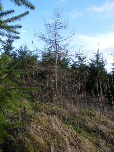
Picture: Summit feature.
Follow the field.
by paddyhillsbagger
5 Feb 2014
Should have followed Fergalh's route but spotted a path on the map a bit further on and thought I'd give it a try. Bad move. Path petered out on crest of hill and got gouged by gorse and tangled in bramble to make the conifer planted top. Wasted more time crawling in the plantation looking for a high point. Best I could come up with is a skeletal tree in a clearing in the midst of the conifers. Fine views when you emerge from copse. Followed the easy route back down following the field boundaries to quarry entrance and was rewarded by spotting a soaring buzzard back up on the hill. Linkback: mountainviews.ie/summit/1295/comment/15823/
Read Less
Read More
Big field to cross first
by Fergalh
2 Jan 2021
Drive north of Mullingar on the Castlepollard road (R394) until you get to Taughmon Church. There is a sign for Owens concrete just beside the church. Drive along this road till you get to Owens concrete (A (N42905 61893)). Opposite the quarry there is a very large field at the top of this veer to right and you will reach the summit.... Linkback: mountainviews.ie/summit/1295/comment/15807/
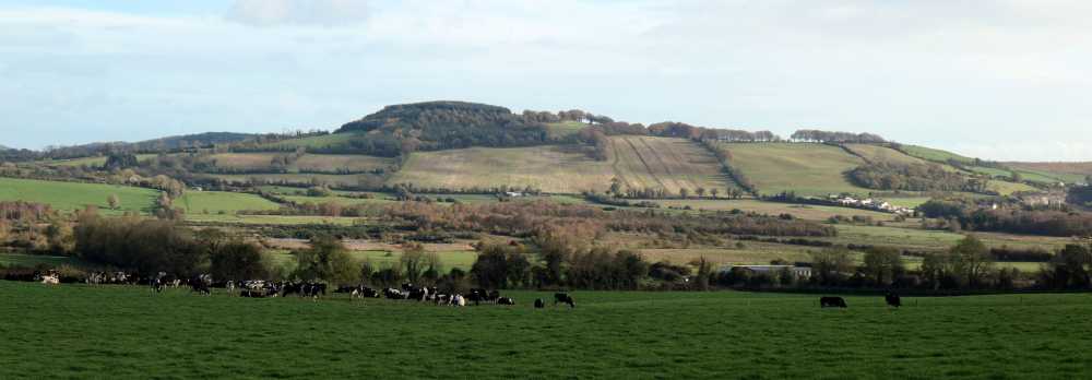
Picture: Cruckboeltane from Junction 16 on the N4 heading west.
Viewed from Junction 16 on the N4 heading west.
by ceadeile
9 Nov 2022
My advice - keep driving until you reach Leitrim or Sligo unless you are an incurable Binnion collector.
Westmeath is not very well endowed with interesting hills but Cruckboeltane must be a candidate for the worst hill in the county.
Time spent searching for the summit, on your knees, under the forest canopy, would be much better spent doing something else - like going for a swim in Lough Owel at Portnashangan. Linkback: mountainviews.ie/summit/1295/comment/23744/
Use of MountainViews is governed by conditions and a privacy policy.
Read general information about the site. Opinions in material here are not necessarily endorsed by MountainViews.
Hillwalking is a risk sport. Information in comments, walks, shared GPS tracks or about starting places may
not be accurate for example as regards safety or access permission. You are responsible for your safety and your permission to walk.
See the credits and list definitions.


 Our Facebook page.