Members and Supporters, the MountainViews Committee requests your help to meet the costs of the website and of other activities such as insured events or publications.
Summits & other features in area North East Midlands: Cen: Ballyjamesduff: Aghalion Hill 249m Cen: Oldcastle: Mullaghmeen 258m, Slieve Na Calliagh 276m, Spire of Lloyd 131m, The Hill of Mael 241m E: Kingscourt: Carrickleck Hill 173m N Cen: Cavan Town: Shantemon 218m, Slieve Glah 320m, Tievenanass 261m NE: Ballybay: Bunnanimma 268m NE: Carrickmacross: Corduff 243m NE: Castleblaney: Mullyash Mountain 317m NE: Cen Bailieborough: Cornasaus 339m, Taghart South 290m NW Cen: Arva: Bruse Hill 260m NW: Aughavas: Lugganammer 190m S Cen: Crookedwood: Cruckboeltane 199m, Knockeyon 214m S: Westmeath South West: Knockastia 200m SE: Boyne Valley: Hill of Slane 160.4m, Mount Oriel 251m, Tara 155m W: Ardagh: Bawn Mountain 200m W: Drumlish: Corn Hill 278m
Note: this list of places may include island features such as summits, but not
islands as such.
Knockeyon, 214mHill
Place Rating ..
, Westmeath County in Leinster province, in Binnion Lists, Knockeyon is the 1374th highest place in Ireland. Knockeyon is the third highest point in county Westmeath.
Grid Reference N46582 63915,
OS 1:50k mapsheet 41 Place visited by: 19members, recently by: MickM45, ger_the_sea, ciaranr, finkey86, TommyMc, groe, Philewis, conormcbandon, jackill, Glanman2, chalky, jlk, eamonoc, paddyhillsbagger, sandman
I visited this place: NO (You need to be a logged-in member for this.)
Short or GPS IDs, 6 char: Knckyn, 10 char: Knockeyon Linkback: https://mountainviews.ie/summit/1273/
Gallery for Knockeyon and surrounds
Summary
for Knockeyon :
Special note.
Summary created by admin
2021-04-07 18:02:23
Special Note. It is recommended that people who visit this hill respect all requests regarding where to park or not to park.
As a result of reports of bad behaviour during lockdown, it is recommended that hillwalkers do not visit this hill at all at present.
It is recommended that when it is possible to go up to always seek permission for visiting. The hill is on private property so please respect the owner's wishes. Do not go up if there are animals in the fields. Leave all gates as you find them with the exception that in the event that you find that a gate is open that might lead to animals straying, shut the gate and tell local people.
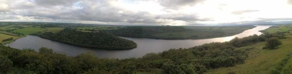
Great views of Lough Derryvaragh and the midlands from to top of Knock Eyon
by ger_the_sea
7 Apr 2021
Fabulous views from the top of Knock Eyon. A short sharp little hill with incredible views for little effort. The whole of Westmeath, Offaly (could def see Edenderry), Wicklow mountains, and not sure how far in the other direction. Great place to see the distinctive Crag and Tails formation of Lough Derryvaragh, formed by tougher chert resisting the glacier that once occupied the Lough.
The instructions from Fergalh are still to the good. It is recommended to seek permission to visit this hill. The new house is now built. There is just about space to park here. Please be sensitive to a number of the residents who have erected no parking signs Respect these and know that it may not be possible to park in the immediate area. Plenty of livestock around the top of the lane but nothing on the hill. Took me 10 mins from car to the top so just a short hop if you're in the area. Well worth it for the views. Linkback: mountainviews.ie/summit/1273/comment/20826/
Read Less
Read More
Bulls are the hazard here !
by Fergalh
7 Apr 2021
Take the (R394) Castlepollard road north of Mullingar ,after passing through Crookedwood you will come to junction for Collinstown shortly after this (the next left) you will come upon a garage on the right. Turn left until crossroads, than turn left again and park at new house being built. Proceed up track till you get to the top of the road there is a series of gates here. The gate you have to go through has beware bull sign ! Now the tricky bit the field has 5 or 6 black and white bulls, skirt around them to get to the trig pillar ! [Note: it is not recommended that visitors to farmland walk through fields of cattle. It is recommended to seek permission for visiting.] Linkback: mountainviews.ie/summit/1273/comment/15808/
Read Less
Read More
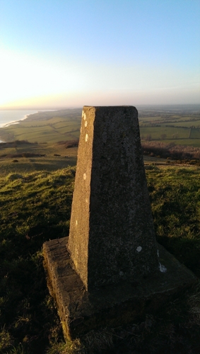
Picture: Summit Trig
Hill of St Eyon
by sandman
11 Mar 2014
Lough Derravaragh made famous by the "Children of Lir" in the background on a very nice spring evening from the summit area. Linkback: mountainviews.ie/summit/1273/comment/15913/
Use of MountainViews is governed by conditions and a privacy policy.
Read general information about the site. Opinions in material here are not necessarily endorsed by MountainViews.
Hillwalking is a risk sport. Information in comments, walks, shared GPS tracks or about starting places may
not be accurate for example as regards safety or access permission. You are responsible for your safety and your permission to walk.
See the credits and list definitions.


 Our Facebook page.