Guestuser: Login or enrol?
- Home
- Main Display
- Main Display (Old)
- Find a Walk
- Display INTRODUCTION
- DONATE
- Click below for your
profile & contributions
guestuserWelcome to MountainViews
If you want to use the website often please enrol (quick and free) at top right.OverviewFor more map options click on any overview map area or any detail map feature.Detail Map FeaturesFind Suggested Walks
Find hill, mountain, island, coastal feature.Videos
Users Online:
Ulsterpooka
Guests online: 639Recent Contributions
 Get Notifications
Carrauntoohil: Above the Clouds: 360 Degree Cloud Inversion
Mangerton & Stoompa
Seefin Mountain West Top: Great paths, closed boardwalk
Carrauntoohil: Above the Clouds: 360 Degree Cloud Inversion
Proctor High Mark: A rocking stone not a rolling one
A tough but rewarding day
Broaghnabinnia West Ridge and Stumpa Duloigh Traverse
Proctor High Mark: Find the gaps in the walls to find the highpoint
Interesting route around Trooperstown, Wicklow.
Clapham High Mark: Find the gaps in the walls to find the highpoint
Parson's Pulpit: Short trek to summit through Burren type landscape
Cahas Surveying: Changes to Arderins etc
Conditions and Info
Use of MountainViews is governed by conditions and a privacy policy.
Read general information about the site.
Opinions in material here are not necessarily endorsed by MountainViews.
Hillwalking is a risk sport. Information in comments, walks, shared GPS tracks or about starting places may not be accurate for example as regards safety or access permission. You are responsible for your safety and your permission to walk.
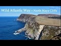
See the credits and list definitions.Video displayNorth Mayo Area N: Benwee Head Cliffs SubareaPlace count in area: 19, OSI/LPS Maps: 22, 23, EW-WNN
Highest place: Maumakeogh, 379m
Maximum height for area: 379 metres, Maximum prominence for area: 294 metres,
Places in area North Mayo:
Cen: Pulathomas:Barnacuillew 260m
E: Ballycastle Hills:Knockaghaleague 237mKnockboha 186mMaumakeogh 379m
N: Benwee Head Cliffs:Benwee Head 255mBarradeegin 229mGlinsk 304mIllanmaster 238mIllanmaster Island 105mPorturlin Hill 155mSrahataggle 182mTawnaghmore 340m
S: Bangor Erris Hills:Carrafull 269mKnocklettercuss 370mKnocknascollop NW Top 244mSheean 295mSlieve Fyagh 335m
W: Belmullet:Aghaglasheen 132mTermon Hill 103m
Note: this list of places includes island features such as summits, but not islands as such.
Mayo County in Connacht Province, in Binnion List, Monotonous massive to banded psammites. Bedrock
Height: 238m OS 1:50k Mapsheet: 23 Grid Reference: F93217 42806
Place visited by 13 members. Recently by: Wilderness, learykid, thrifleganger, justynagru, Fergalh, gerrym, IainT, IncaHoots, sandman, shaunkelly, Garmin, barrymayo, chalkyI have visited this place: NO (You need to be a logged-in member to change this.)Longitude: -9.641889, Latitude: 54.322806 , Easting: 93217, Northing: 342806 Prominence: 134m, Isolation: 0.3km
ITM: 493190 842807 , GPS IDs, 6 char: Ilnmst, 10 char: Ilanmaster
Bedrock type: Monotonous massive to banded psammites., (Broad Haven Formation)
Illanmaster is the 1313th highest place in Ireland.
Linkback: https://mountainviews.ie/summit/1235/COMMENTS for Illanmaster 1 of 1  Follow this place's comments


MountainViews.ie, a Hill-walking Website for the island of Ireland. 2400 Summiteers, 1480 Contributors, maintainer of lists: Arderins, Vandeleur-Lynams, Highest Hundred, County Highpoints etc

 Lauranna
 Leatra
 Lauranna
 Fergalh
 billbaggins
 Fergalh
 Fergalh
 Fergalh
 simon3
 Visit our Facebook page.