This website uses cookies, which are small text files that the website puts on your device to facilitate operation. Cookies help us provide a better service to you. They are used to track general user traffic information and to help the website function properly.
Feature count in area: 19, all in Mayo,
OSI/LPS Maps: 22, 23, EW-WNN
Highest Place: Maumakeogh 379m
Starting Places (9) in area North Mayo: Bangor Trail Head, Carnhill, Carrowmore Wood, Erris Head, Portacloy Bay, Proesoon, Sralagagh West, Termon Hill Road, Tower Hill South
Summits & other features in area North Mayo: Cen: Pulathomas: Barnacuillew 260m E: Ballycastle Hills: Knockaghaleague 237m, Knockboha 186m, Maumakeogh 379m N: Benwee Head Cliffs: Benwee Head 255m, Barradeegin 229m, Glinsk 304m, Illanmaster 238m, Illanmaster Island 105m, Porturlin Hill 155m, Srahataggle 182m, Tawnaghmore 340m S: Bangor Erris Hills: Carrafull 269m, Knocklettercuss 370m, Knocknascollop NW Top 244m, Sheean 295m, Slieve Fyagh 335m W: Belmullet: Aghaglasheen 132m, Termon Hill 103m
Note: this list of places may include island features such as summits, but not
islands as such.
Slieve Fyagh, 335mHill Sliabh Fíoch A name in Irish,
Place Rating ..
(Ir. Sliabh Fíoch [GÉ], poss. 'mountain abounding in deer'), Mayo County in Connacht province, in Binnion Lists, Slieve Fyagh is the 1087th highest place in Ireland.
Grid Reference F91976 28374,
OS 1:50k mapsheet 23 Place visited by: 9members, recently by: eamonoc, Fergalh, sandman, Garmin, chalky, FilHil, shadow100, maxim, Big-Foot
I visited this place: NO (You need to be a logged-in member for this.)
Longitude: -9.655812, Latitude: 54.192939, Easting: 91976, Northing: 328374,
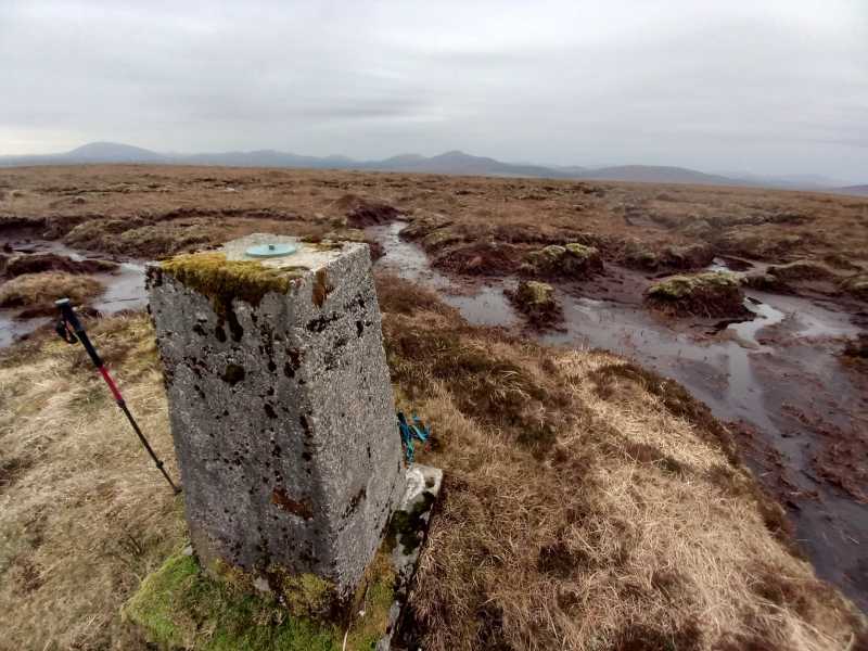
Prominence: 190m, Isolation: 6.1km, Has trig pillar
ITM: 491945 828378 Bedrock type: X-bedded sandstone and siltstone., (Minnaun Sandstone Formation) Notes on name: Fíoch is the modern Irish form of fiadhach, 'abounding in deer' (fia/fiadh).
Short or GPS IDs, 6 char: SlvFyg, 10 char: SlvFygh Linkback: https://mountainviews.ie/summit/918/
Gallery for Slieve Fyagh (Sliabh Fíoch) and surrounds
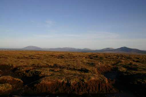
At approx point A (F934 343) turned north onto minor road and drove to point B (F93986 28976).
From here continued on about 500m until the track disappeared. From here started to head in a westerly direction towards the summit at C (F91976 28376).
The summit and the approaches are blanket bog, so it was wet even though it hadn't rained in a few days. Gaitors would have been useful. The whole walk took about 90minutes to complete. Linkback: mountainviews.ie/summit/918/comment/3762/
Use of MountainViews is governed by conditions and a privacy policy.
Read general information about the site. Opinions in material here are not necessarily endorsed by MountainViews.
Hillwalking is a risk sport. Information in comments, walks, shared GPS tracks or about starting places may
not be accurate for example as regards safety or access permission. You are responsible for your safety and your permission to walk.
See the credits and list definitions.


 Our Facebook page.