Donation Request 2024
You do not have to be logged in to donate.
DONATE
Members and Supporters, the MountainViews Committee requests your help to meet the costs of the website and of other activities such as insured events or publications.You do not have to be logged in to donate.
Welcome to MountainViews
If you want to use the website often please enrol (quick and free) at top right.
If you want to use the website often please enrol (quick and free) at top right.
Overview

For more map options click on any overview map area or any detail map feature.
Detail Map Features
Showing 1 items:
Knocknascollop NW Top 244m,
Knocknascollop NW Top 244m,
Find Suggested Walks
Find hill, mountain, island, coastal feature.
Videos
Recent Contributions
 Get Notifications
Get Notifications
Crocknasharragh: Fine views on ascent
 Colin Murphy
Lake District: Dale Head Horseshoe
Crocknasharragh: Impressive views on nitial ascent.
 Colin Murphy
Lake District: Coledale Horseshoe
Cunnigar: Short trek to summit
 Fergalh
Longish walk to isolated top
 Colin Murphy
Westtown Hill: Tramore's Highest Point
 DeirdreM
Knockbrinnea West Top: Eflanagan on the Knockbrinneas
 eflanaga
Ascending the Knockbrinneas from the north.
 simon3
Knockbrinnea West Top: Larger Twin
 Collaborative entry
Lobawn Loop - Clockwise avoids any steep ascent! Easy stream crossing.
Knockaunanattin West Top: Views, loughs and a navigational aid.
 simon3
Conditions and Info
Use of MountainViews is governed by conditions and a privacy policy.
Read general information about the site.
Opinions in material here are not necessarily endorsed by MountainViews.
Hillwalking is a risk sport. Information in comments, walks, shared GPS tracks or about starting places may not be accurate for example as regards safety or access permission. You are responsible for your safety and your permission to walk.
See the credits and list definitions.
 Visit our Facebook page.
Video display
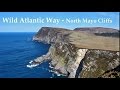
North Mayo
Area S: Bangor Erris Hills Subarea
Place count in area: 19,
OSI/LPS Maps: 22, 23, EW-WNN
Highest place: Maumakeogh, 379m
Maximum height for area: 379 metres,
Maximum prominence for area: 294 metres,
Places in area North Mayo:
Cen: Pulathomas:Barnacuillew 260m
E: Ballycastle Hills:Knockaghaleague 237mKnockboha 186mMaumakeogh 379m
N: Benwee Head Cliffs:Benwee Head 255mBarradeegin 229mGlinsk 304mIllanmaster 238mIllanmaster Island 105mPorturlin Hill 155mSrahataggle 182mTawnaghmore 340m
S: Bangor Erris Hills:Carrafull 269mKnocklettercuss 370mKnocknascollop NW Top 244mSheean 295mSlieve Fyagh 335m
W: Belmullet:Aghaglasheen 132mTermon Hill 103m
Note: this list of places includes island features such as summits, but not islands as such.
Highest place:
Maumakeogh, 379mPlaces in area North Mayo:
Cen: Pulathomas:
Barnacuillew 260mE: Ballycastle Hills:
Knockaghaleague 237mKnockboha 186mMaumakeogh 379mN: Benwee Head Cliffs:
Benwee Head 255mBarradeegin 229mGlinsk 304mIllanmaster 238mIllanmaster Island 105mPorturlin Hill 155mSrahataggle 182mTawnaghmore 340mS: Bangor Erris Hills:
Carrafull 269mKnocklettercuss 370mKnocknascollop NW Top 244mSheean 295mSlieve Fyagh 335mW: Belmullet:
Aghaglasheen 132mTermon Hill 103mNote: this list of places includes island features such as summits, but not islands as such.

Bedrock type: Banded, graded and X-bedded quartzites., (Bangor/Corslieve Formation)
This hill, which is the highest point on a ridge consisting of three peaks, is unnamed on OS maps. However, the name Knocknascollop is given for the SE peak on the Discovery map, and on William Bald's map of Co. Mayo (1830) the NW peak is marked Knock-na-Skalib (effectively the same name), showing that this name applies to the whole ridge. Scollops are looped sticks used to secure thatch on a roof. The name probably refers to the notched appearance of the ridge. Previously Carrowmore Hill in MV. Knocknascollop NW Top is the 1292th highest place in Ireland.
Linkback: https://mountainviews.ie/summit/1006/
COMMENTS for Knocknascollop NW Top (Cnoc na Scolb (mullach thiar thuaidh)) 1 of 1  Follow this place's comments

|
|
|
|
||
| MountainViews.ie, a Hill-walking Website for the island of Ireland. 2400 Summiteers, 1480 Contributors, maintainer of lists: Arderins, Vandeleur-Lynams, Highest Hundred, County Highpoints etc | |||