This website uses cookies, which are small text files that the website puts on your device to facilitate operation. Cookies help us provide a better service to you. They are used to track general user traffic information and to help the website function properly.
Feature count in area: 19, all in Mayo,
OSI/LPS Maps: 22, 23, EW-WNN
Highest Place: Maumakeogh 379m
Starting Places (9) in area North Mayo: Bangor Trail Head, Carnhill, Carrowmore Wood, Erris Head, Portacloy Bay, Proesoon, Sralagagh West, Termon Hill Road, Tower Hill South
Summits & other features in area North Mayo: Cen: Pulathomas: Barnacuillew 260m E: Ballycastle Hills: Knockaghaleague 237m, Knockboha 186m, Maumakeogh 379m N: Benwee Head Cliffs: Benwee Head 255m, Barradeegin 229m, Glinsk 304m, Illanmaster 238m, Illanmaster Island 105m, Porturlin Hill 155m, Srahataggle 182m, Tawnaghmore 340m S: Bangor Erris Hills: Carrafull 269m, Knocklettercuss 370m, Knocknascollop NW Top 244m, Sheean 295m, Slieve Fyagh 335m W: Belmullet: Aghaglasheen 132m, Termon Hill 103m
Note: this list of places may include island features such as summits, but not
islands as such.
Glinsk, 304mHill Glinsce A name in Irish,
Place Rating ..
(Ir. Glinsce [logainm.ie], poss. 'valley difficult of access'), Mayo County in Connacht province, in Binnion Lists, Glinsk is the 1152th highest place in Ireland.
Grid Reference F94819 42044,
OS 1:50k mapsheet 23 Place visited by: 15members, recently by: Wilderness, thrifleganger, justynagru, Fergalh, gerrym, IainT, sandman, shaunkelly, Garmin, chalky, barrymayo, scapania, Geansai, Frank12345, IncaHoots
I visited this place: NO (You need to be a logged-in member for this.)
Longitude: -9.617011, Latitude: 54.316295, Easting: 94819, Northing: 342044,
Prominence: 179m, Isolation: 1.8km ITM: 494792 842045 Bedrock type: Monotonous massive to banded psammites., (Broad Haven Formation) Notes on name: There are several townlands named Glinsce in the west of Ireland (anglicised as Glinsk, Gleensk or Gleesk). Several, though not all, are in rather remote valleys or ravines, of which the ravine N of this peak is a fine example. The name is obscure but may refer to a valley difficult of access. The remains of a signal tower are located SE of the summit. Walks: for a cliff-top route from Porturlin to Belderg, passing near Glinsk, see Whilde & Simms, New Irish Walk Guide - West and North, 78-79.
Short or GPS IDs, 6 char: Glinsk, 10 char: Glinsk Linkback: https://mountainviews.ie/summit/954/
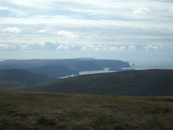
Picture: Looking West across the coast from Glinsk top
Cliffside
by Geansai
3 Jul 2011
I went over a gate and a little way up the track off the road marked on the os map to the east of Glinsk before turning left onto the hill. Don't know about parking at that gate. I had walked down to the road from Tawnaghmore, having parked I was to discover a fifty minute walk down the road from this track which you only go up a little way. Its a rough but short climb over the heather. There is a little ridge between two high points. The unmarked summit area is on the southern side further away from the sea. No cairn. On the northern high point you can walk down towards the cliffs before being confronted by a barbed wire fence. I didn't bother trying to get over it. I could see a sailing boat heading east close to the coast below. On the way up Tawnaghmore I could make out the faint shape of cliffs on the Donegal coast, but they were no longer visible despite the clear weather. Good views across the North Mayo coast though. Then it was back down the hill and a pleasant but long walk back to the car. Linkback: mountainviews.ie/summit/954/comment/6397/
Read Less
Read More
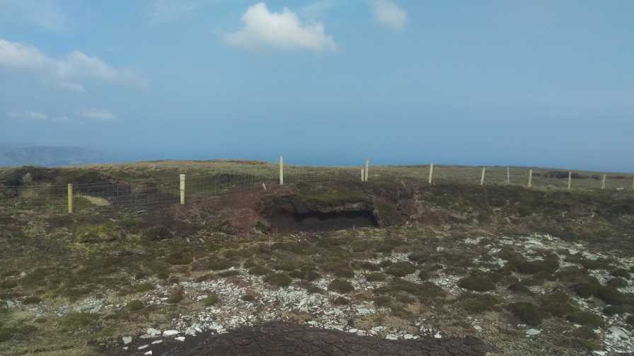
Picture: Summit Area.
Start or Finish.
by sandman
31 May 2016
Yes just like Porturlin this hill can be the start or finish of a fantastic coastal walk and parking for two cars is available at A (F94991 41027) and by crossing the fence you will pass a very old derelict house on the way to the summit. Please be advised that the coastal walk contains a number of fences you need to cross. Linkback: mountainviews.ie/summit/954/comment/18558/
Use of MountainViews is governed by conditions and a privacy policy.
Read general information about the site. Opinions in material here are not necessarily endorsed by MountainViews.
Hillwalking is a risk sport. Information in comments, walks, shared GPS tracks or about starting places may
not be accurate for example as regards safety or access permission. You are responsible for your safety and your permission to walk.
See the credits and list definitions.


 Our Facebook page.