This website uses cookies, which are small text files that the website puts on your device to facilitate operation. Cookies help us provide a better service to you. They are used to track general user traffic information and to help the website function properly.
Starting Places (16) in area South East Midlands: Ballinvarry West, Clodiagh Church, Coolnahau, Coppanagh Wood South, Freney's Well, Glynn, Gorlough Wood, Hill of Allen, Inistioge, Killamery Wood East, Kylebeg Wood, Lingaun River, Mount Alto Wood, Mullenbeg Wood South, Newtown Upper School, Slievenamon Walk Head
Summits & other features in area South East Midlands: E: Barrow: Clogrennan Hill 336m, Newtown Hill 208m N Cen: Timahoe Hills: Ballaghmore Hill 268m, Cullenagh Mountain 317m, Fossy Mountain 332m, Hewson Hill 261m N: Croghan: Croghan Hill 234m N: Newbridge Hills: Dunmurry Hill 233m, Hill of Allen 219m S: Mullinavat: Coolnahau Hill 265m, Corbally Hill 285m, Mount Alto 276m, Tory Hill 292m S: Slievenamon: Knockahunna 502.8m, Sheegouna 553.5m, Slievenamon 720.2m, Slievenamon North-West Top 564m S: Windgap: Carricktriss Gorse 314m, Carrigadoon Hill 296.9m, Faranaree Hill 283m SE: Brandon Hill: Brandon Hill 515m, Coppanagh 365m, Croghan 365m W Cen: Durrow: Ballynalacken Hill 314m, Caponellan Hill 253m, Knockmannon Hill 315m W Cen: Slieveardagh: Clomantagh Hill 349m, Knocknamuck 340m, Monabrogue 284m W: Horse & Jockey: Kill Hill 241m, Killough 235m
Note: this list of places may include island features such as summits, but not
islands as such.
Ballaghmore Hill, 268mHill
Place Rating ..
, Laois County in Leinster province, in Binnion Lists, Ballaghmore Hill is the 1243th highest place in Ireland.
Grid Reference S58654 93754,
OS 1:50k mapsheet 55 Place visited by: 14members, recently by: Moirabourke, Pepe, moggy40, SenanFoley, markwallace, High-King, melohara, Dessie1, chalky, sandman, wicklore, paddyhillsbagger, Fergalh, eamonoc
I visited this place: NO (You need to be a logged-in member for this.)
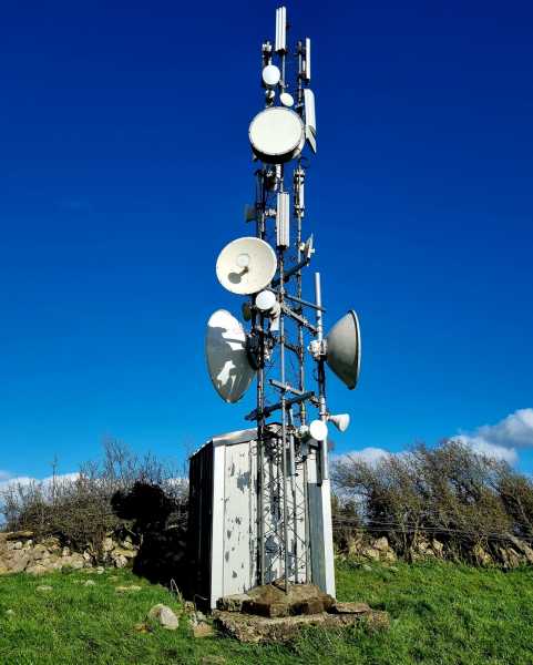
On Thursday 6th Feb I ascended Ballaghmore Hill.Started at A (S58898 94220), Climbed over gate and followed rough farm track uphill past some sheds until I reached another two gates, track very mucky here, climbed gate and headed uphill to the right towards communications mast clearly visible from gates. This is all farm land with a lot of grazing cattle, no one around to enquire about access. It was nice to see this hill made it onto Mt Views because it invokes many pleasant memories for me, the last time I was up what I knew as Ballyprior Hill was about 1986, then I was a mere strap of a lad who regularly ran up here with my faithful four legged friend Schooner, he sadly got a leg caught in a snare and became my three legged friend. Undaunted he still made the trip many times after that. I was a bit dissappointed to see that Ballaghmore is now crowned with two communication masts. Still though, thanks Mt Views for the memories. Nice views in all directions especially towards Wicklow Mts. Linkback: mountainviews.ie/summit/1194/comment/15834/
Read Less
Read More
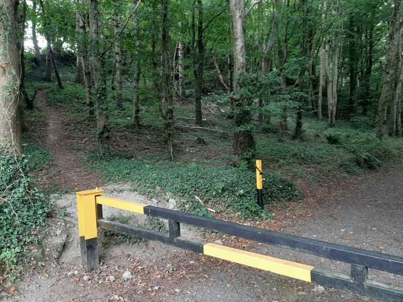
Picture: Forest barrier, path to the left.
A handy hill for the local 100
by High-King
4 Sep 2021
Needed to climb Ballaghmore Hill for my local 100. No great challenge. Left Stradbally behind me and drove up the hill towards Arles/Carlow. At the top of the hill I pulled in at the forestry entrance. There is an agricultural gate on the left that has a "Beware of the bull" sign.. I went up to the forestry barrier and found a path right on the left. I followed this path along the edge of the forest. Whe the path topped out I entered the field. The masts are clearly visible. I walked through the field to the top. Whole trip is under a half hour. Linkback: mountainviews.ie/summit/1194/comment/23262/
Read Less
Read More
Handy Photo
by Pepe
7 Apr 2024
Thanks to High-King for uploading that photo of the forestry barrier with the recommended path to the left. Once I arrived at the forestry gate I know from the photo that I was in the correct spot to start. Wasn't sure which of the three sets of masts marked the top so visited all three. Luckily the cattle were all on the other, western, side of the fence that runs along the summit area. Linkback: mountainviews.ie/summit/1194/comment/24173/
Read Less
Read More
Lovely peak, easy trail.
by Arcticaurora
8 Apr 2024
Followed High-King's instructions which were perfect. A lovely peak with great views. No cattle or bull in the field with the masts luckily! Linkback: mountainviews.ie/summit/1194/comment/24175/
Use of MountainViews is governed by conditions and a privacy policy.
Read general information about the site. Opinions in material here are not necessarily endorsed by MountainViews.
Hillwalking is a risk sport. Information in comments, walks, shared GPS tracks or about starting places may
not be accurate for example as regards safety or access permission. You are responsible for your safety and your permission to walk.
See the credits and list definitions.


 Our Facebook page.