This website uses cookies, which are small text files that the website puts on your device to facilitate operation. Cookies help us provide a better service to you. They are used to track general user traffic information and to help the website function properly.
Feature count in area: 24, by county: Kerry: 12, Cork: 14, of which 2 are in both Cork and Kerry,
OSI/LPS Maps: 79
Highest Place: The Paps East 694m
Starting Places (28) in area Derrynasaggart: Carrigallisy, Clonee, Dromiscane Castle, Fuhiry Wood, Garrane Bridge, Garries Bridge, Glannafreaghaun Lough N, Glannafreaghaun Lough S1, Glannafreaghaun Lough S2, Gortavehy Lough, Grousemount Wind Farm, Inchamore Woods N, Inchamore Woods W, Kippagh Lough, Knocknabro Wood, Knockullane, Liam Hegarty Monument, Loo River Junction, Lough Murtagh, Millstreet, Mullaghanish Transmitter Gate, Old Rail Level Crossing, Paps Walk S, River Roughty, Rossacroo na Loo Forest, Sillahertane Stream, The Mills Inn, Top of Coom
Summits & other features in area Derrynasaggart: Cen: Knocknabro: Knocknabro East Top 530m, Knocknabro NE Top 535m, Knocknabro West Top 592m, Knocknagowan 574m N: Caherbarnagh: Caherbarnagh 681m, Caherbarnagh East Top 549m, Caherbarnagh NW Top 668m, Claragh Mountain 452m, Curracahill 478m SE: Mullaghanish: Ballyvouskill 401m, Knockacommeen 426m, Knockullane 462m, Knockullane East Top 408m, Mullaghanish 649m, Mullaghanish North-East Top 586.4m, Mullaghanish Far North-East Top 558.5m SW: Coomagearlahy: Knockbwee 461m, Cummeenboy 442m, Coomagearlahy 506m, Coomagearlahy West Top 462m, Dereenaculling 303m W: The Paps: Coolcurtoga 425m, The Paps East 694m, The Paps West 690m
Note: this list of places may include island features such as summits, but not
islands as such.
The Paps East, 694mMountain An Dá Chích Anann - An Chíoch Thoir A name in Irish,
Place Rating ..
(Ir. An Dá Chích [OSI], 'the two breasts'), Kerry County in Munster province, in Arderin, Vandeleur-Lynam, Irish Highest Hundred Lists, The Paps East is the highest mountain in the Derrynasaggart area and the 120th highest in Ireland.
Grid Reference W13323 85542,
OS 1:50k mapsheet 79 Place visited by: 368members, recently by: michaelseaver, rhw, Nailer1967, westside, maryblewitt, Leatra, Petecal423, Deirdreb, orlaithfitz, knightsonhikes, Cunn2000, ConMack23, Chopper, ToughSoles, Barrington1978
I visited this place: NO (You need to be a logged-in member for this.)
Longitude: -9.263178, Latitude: 52.015624, Easting: 113323, Northing: 85542,
Prominence: 623m, Isolation: 0.8km ITM: 513294 585599 Bedrock type: Green sandstone & purple siltstone, (Glenflesk Chloritic Sandstone Formation) Notes on name: The Dictionary of Celtic Mythology gives the full name as Dá Chích Anann, 'the two breasts of Anu'. This goddess was reputedly responsible for the fertility of the whole province of Munster. A line of stones, known as na Fiacla, connects the two tops and is believed to have formed a processional route.
Short or GPS IDs, 6 char: ThPpsE, 10 char: ThPpsEst Linkback: https://mountainviews.ie/summit/116/
Gallery for The Paps East (An Dá Chích Anann - An Chíoch Thoir) and surrounds
Summary
for The Paps East (An Dá Chích Anann - An Chíoch Thoir):
Steep pull up and fine views from the east 'Breast of Anú'
Summary created by markmjcampion, simon3
2023-05-04 14:35:19
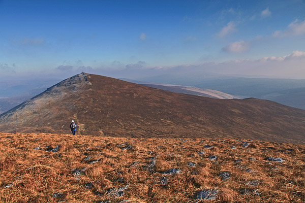
Picture: The Paps East and its southern tail to the right.
This is the higher of the two Paps, the most distinctive pair of summits in Ireland and a v evocative sight when seen from the window of the Kerry-bound train. It's grassy and heathery with a huge cairn which is neolithic passage tomb. The East and West Paps are on almost an exact E-W line, have very similar shapes when viewed from most angles except south and are only around 4m different in height. Great views of the West Pap and its southern ridge, the Mangerton group, Derrynasaggarts and the plains of N Kerry.
S. Park in the Clydagh Valley at Paps Walk S (W14446 84029). Walk up the track to approx. Gl'frekan S2 (W14304 85244) and head W. There are a number of tracks, not totally consistent, that can be found that will take you through the steep, heather-covered lower slopes to the higher ground which has lower vegetation cover. 1.5 hrs
From the same starting point you can also head W along the road to A (W13762 83687). From here take the trail to the N and head into the forest , exiting at B (W13352 83944). You can then follow the stream to the col between the two paps and summit easily from there. 1.5hrs+
NE. Park at C (W14752 86862) and walk S on a good trail past Glannafreaghaun Lough to Gl'frekan S2 (W14304 85244) and head W as above. 1.5 hrs
N. Park at D (W13834 88245), follow the Duhallow Way to Gl'frekan S2 (W14304 85244) and head W as above. 2 hrs
W. Another way of reaching the summit is from the West Pap…it’s a short walk over and back. See its page for access.
Notable tracks incl track/2852, track/1752 and track/4096
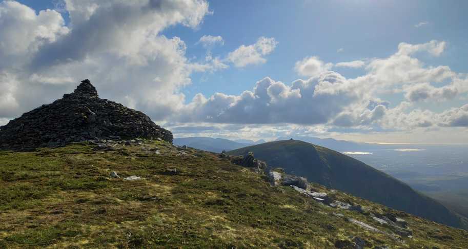
The peak of the eastern most Pap looking towards the other Pap and Killarney and Magillycuddys. Taken on 05/06/2019, which was a pleasant and sweaty evening. Linkback: mountainviews.ie/summit/116/comment/20551/
Read Less
Read More
Ya Gotta Visit Both
by JohnFinn
7 Jul 2022
I'm posting this under The Paps East but I can't imagine anyone doing just one Pap; if you go there you really have to do both - it's a short and easy trek from one to the other. We did a loop walk of 9.3 kms taking in the East Pap first and then going on to the West Pap. (I've posted the gpx of the route - it's number 4689.)
There is ample parking by the sign for Shrone Lake. After 1.06 kms on the track we took a fairly obvious left turn and it was then an easy ascent - mainly through heather but with some sheep paths as well - to the East summit cairn. The weather had deteriorated during the ascent and we had to don our wet gear but conditions improved by the time we got to the top which we reached in 1.5 hours.
It was then down into the col between the two Paps and up on to the West one where the clouds had lifted and we were able to exult in the wonderful views in all directions.
From there we made our way back to the road and a 1.5 km walk to the cars. Total time was 4.5 hours. An easy and rewarding hike and highly recommended.
Note: if you are coming from the Cork direction your SatNav may tell you to take the first right turn after the county bounds - the L11182. Do not take that road as it is very narrow. Take the next one instead - the L7058 and signposted for Clonkeen and the Clydagh Valley. Drive to the end of the road where you will see the sign for Shrone Lake. Linkback: mountainviews.ie/summit/116/comment/23577/
Read Less
Read More
pdtempan on The Paps East
by pdtempan
23 Nov 2003
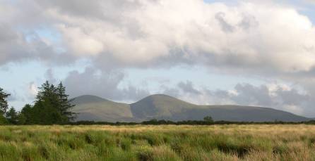
Here the Paps are seen from Banard, near Gneeveguilla, about 5 miles to the north. Their name in Irish is An Dá Chích Anann ('the two breasts of Anu', a pagan Irish deity said to be responsible for the fertility of the whole province of Munster). The megalithic cairns on each summit, which enhance the resemblance to the goddess' breasts, have recently been excavated and confirmed to cover passage tombs, which may be as old as the Neolithic era. Linkback: mountainviews.ie/summit/116/comment/756/
Read Less
Read More
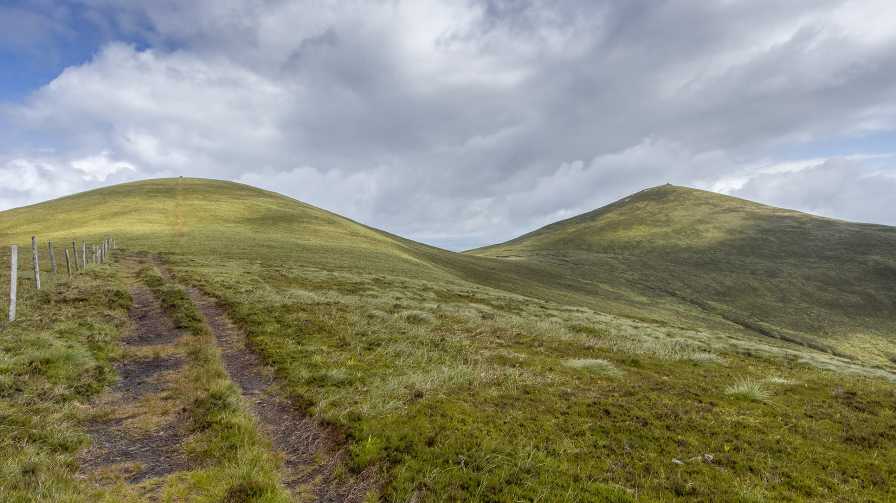
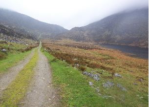
Picture: Lough Glannafreaghaun track
Colin Murphy on The Paps East
by Colin Murphy
12 May 2008
A barely surfaced 'road' allows you to drive to the northern tip of Lough Glannafeaghaun where you'll find a gate and space for a couple of cars to park beyond it. From there a track (pictured) leads along the eastern side of the lake past some ruggedly beautiful scenery. From the southern end of the lake you can then ascend to The Paps East over some steep and rough terrain. Taking in Paps West is relatively easy after that, unfortunately though the only route home is to retrace your steps. Unfortunately also the day we chose our view from the tops through a soupy mist was about ten metres. Second pic shows the impressively large Paps East Cairn. Linkback: mountainviews.ie/summit/116/comment/3098/
Read Less
Read More
paulocon on The Paps East
by paulocon
9 Aug 2009
Surely one of Ireland's iconic mountains and it's easy to see why it cast such a spell on the pre-Christian inhabitants of the area. I took an early start on holidays to tackle the Paps. Went via the route outlined in the book 'Kerry Walks'. Basically, on the Killarney to Ballyvourney road, take the first turn for Clonkeen on the Killarney side. You will pass Clonkeen church and shortly afterwards a road to the left is signed 'Clydagh Valley'. Follow this narrow road for just over 2.5 miles after which you will see a laneway/trail to the left surrounded by some farm buildings and some evergreen trees. There is space here to park your car. Follow this laneway through 2 gates and after the second a firebreak in the trees to the left takes you up onto the open slopes of Paps East. Note that the climb up the firebreak is very steep and extremely wet and slippy in places. Once on the open slopes, pick a pathway up to the summit through the heavy heather where the going can be quite tough. I had one of those 'why the hell am I doing this' moments as I struggled up the hill at 6 in the morning as the rain came down and the mist moved in over the summit. The cairn upon the summit is massive but the heavy mist hid any views across to the second pap or out to the surrounding region. You have the option now to head across to the Paps West or head straight back down. If heading over to the Western Pap, make sure not to stray too close to the cliffs that run down to Lough Nageeha. On your desent, take care descending back down the firebreak as it's quite treacherous in places. Treated to a rainbow over the mountain as I took the trail back to my car and back home to join the rest of the family for breakfast! Linkback: mountainviews.ie/summit/116/comment/4007/
Use of MountainViews is governed by conditions and a privacy policy.
Read general information about the site. Opinions in material here are not necessarily endorsed by MountainViews.
Hillwalking is a risk sport. Information in comments, walks, shared GPS tracks or about starting places may
not be accurate for example as regards safety or access permission. You are responsible for your safety and your permission to walk.
See the credits and list definitions.


 Our Facebook page.