This website uses cookies, which are small text files that the website puts on your device to facilitate operation. Cookies help us provide a better service to you. They are used to track general user traffic information and to help the website function properly.
Feature count in area: 16, all in Mayo,
OSI/LPS Maps: 22, 30, CBW, EW-ACC, EW-ACC
Highest Place: Croaghaun 688m
Starting Places (16) in area Achill & Corraun: Achillbeg Island, Achillbeg Mid West Beach, Barneygappul Strand, Belfarsad Bridge, Breanaskill, Bunanioo Church, Cartron River, Clare Island, Doogort Beach, Fiodián na Circe, Keem Bay, Lough Acorrymore, Lough Gall, Minaun Mast, Rossnafinna Island, Tobercolman Cross Cemetery
Summits & other features in area Achill & Corraun: Cen: Minaun: Minaun (Achill Island) 466m N: Slievemore: Krinnuck (Achill Island) 214m, Slievemore (Achill Island) 671m NW: Croaghaun: Benmore (Achill Island) 332m, Cornaclea Hill (Achill Island) 269m, Croaghaun (Achill Island) 688m, Croaghaun SW Top (Achill Island) 664m S: Knockmore Achill: Achillbeg Island N Top (Achillbeg Island) 109.7m, Achillbeg Island S Top (Achillbeg Island) 108.5m, Knockmore (Achill Island) 337m, Tievereivagh (Achill Island) 286m SE: Corraun: Knocklettragh 452m, Corraun Hill 524m, Corraun Hill Highpoint 541m SW: Clare Island: Knockmore (Clare Island) 462m, Knocknaveen (Clare Island) 223m
Note: this list of places may include island features such as summits, but not
islands as such.
Krinnuck, 214mHill Cruinneog A name in Irish,
Place Rating ..
(Ir. Cruinneog [Siúlóidí Acla*], 'little round one') Doogort Hill an extra name in English, Cruinnchnoc, Mayo County in Connacht province, in Binnion Lists, Krinnuck is the 1376th highest place in Ireland. Krinnuck is the second most northerly summit in the Achill & Corraun area. Reachable "On Foot " Y Grid Reference F68102 07914,
OS 1:50k mapsheet 22,30 Place visited by: 31members, recently by: poopoobasto, Wilderness, Carolyn105, annem, Ulsterpooka, hivisibility, Fergalh, markmjcampion, frankmc04, Oileanach, David-Guenot, Garmin, chalky, garrettd, Tran, Island visited by 554 members.
I visited this place: NO (You need to be a logged-in member for this.)
, I visited this island: NO
Longitude: -10.012369, Latitude: 54.003674, Easting: 68102, Northing: 307914,
Prominence: 159m, Isolation: 3.2km ITM: 468081 807923 Bedrock type: Banded psammitic and pelitic schists., (Ridge Point Psammitic Formation) Notes on name: This hill is unnamed on OS maps but is mentioned in the Co. Mayo Development Plan as Doogort Hill. However, a local bi-lingual walking guide names as Cruinneoc (which has here been standardised to Cruinneog), a wonderfully descriptive name for this little round hill. The round shape is very evident from the pattern of concentric oval-shaped contours on the map. The anglicised form Krinnuck is found on William Bald's map of Mayo (1830). This is a good example of how easily local names can be lost and are sometimes unknown even to local authorities in whose area they are located. For a walk around the base of Krinnuck, see Siúlóidí Acla, walk F.
Short or GPS IDs, 6 char: Krnck, 10 char: Krinnuck Linkback: https://mountainviews.ie/summit/1032/
Gallery for Krinnuck (Cruinneog) and surrounds
Summary
for Krinnuck (Cruinneog):
A rewarding short climb
Summary created by Harry Goodman
2010-06-25 07:21:42
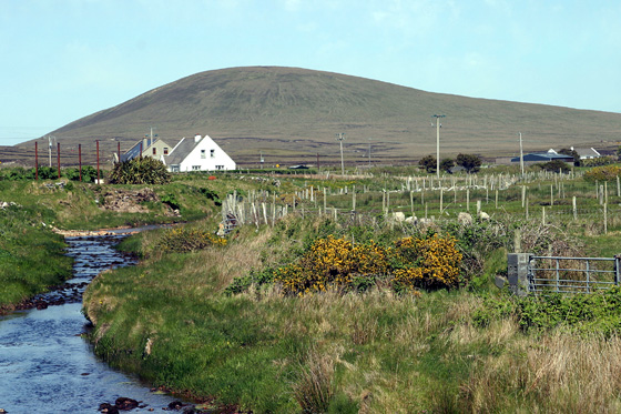
Picture: Krinnuck from the south looking along the Gallagher River
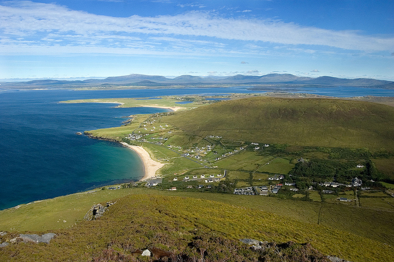
Access can be gained from the road that runs around the western and northern flanks of the hill. From the north at A (F68258 09035) a rough stoney track , not immediately apparent because of thick undergrowth, runs due south out to the open hillside. From here, continuing due south it is a gradual climb over short heather and grass to the lower cairned top and then across the flat broad ridge to the slightly higher but unmarked top of the hill at B (F68053 07877). Access can also be gained from the southwest by a track starting at Circe (F67200 06900). Though small in stature this hill gives fine views southwest across Achill Island, north to the lowlands of the Belmullet Peninsula and east across Inishbiggle to the Nephin Beg Range. In dry conditions the ground will be soft and springy but when wet will be quite marshy.
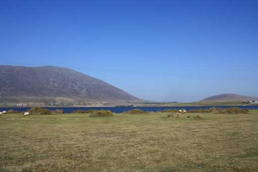
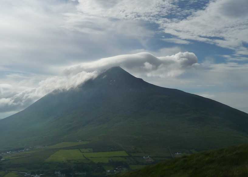
Pdtempan informs us that Krinnuck is derived from Cruinneog meaning “Little Round Hill”, and that a glance at the map contours will highlight the rounded nature of the hill. My photo shows exactly how Small & Rounded Krinnuck is-especially when it is contrasted with its large neighbour Slievemore to the west! Slievemore is only 3 times higher, but its bulk helps it to completely dominate Krinnuck in the picture. Linkback: mountainviews.ie/summit/1032/comment/3667/
Read Less
Read More
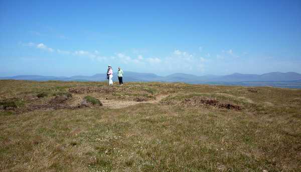
Picture: Walkers on Krinnuck
A nondescript but rewarding top
by Harry Goodman
13 Sep 2023
Started at A (F68258 09035) (25 May 2010). There is a rough track going S to the right of, and along side, a raised bank marking the boundary of a small white house set back from the road. Due to the undergrowth the track may not be immediately seen from the road but should be easily found. It leads out directly to the hillside from where we continued our walk due S up to the lower top, with a small cairn, and then across the flat broad ridge to the slightly higher "summit" which is nondescript with no identifying marker whatsoever. We returned by the way of ascent. Out and back was 2.6k and, at a strollers pace, took less than an hour. The short walk along the broad flat top, allowed one to savour the picturesque delights of Achill. Just across W was the sharp cone of Slievemore, while a little to the south of it was the fine bulky outline of Croahaun. Further S were the Cliffs of Menawn while to the E across Inishbiggle we saw the long line of the Nephin Beg Range. On the way back down the lowlands of the Belmullet Peninsula were constantly in view. I found this a delightful short walk which was well worth the little effort required to complete it and which could be easily slotted in on a general sightseeing day visit to Achill. However I must also record that when we were on Achill there had been a particularly dry spell of weather and the underfoot conditions were excellent. After wet weather things might be different when springy turf turns to sludge ! This said it would still not be a difficult walk. Linkback: mountainviews.ie/summit/1032/comment/5855/
Read Less
Read More
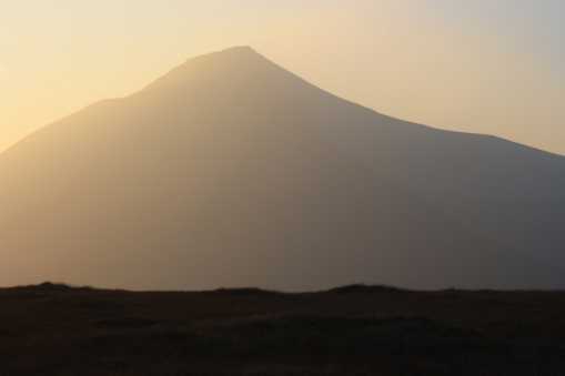
Picture: A lovely evening view from Krinnuck
Wicklore reaches the top.
by wicklore
13 Sep 2023
I decided to climb Krinnuck to round off a days walking on Achill Island. I found a little track where I could pull the car off the road at Circe (F672 069). From here it was a straightforward haul across bog and up to the summit. The ground is awkward at times-wet and boggy in places and teeming with hidden hollows under the heather in others. However it is less than 20 minutes to the top, so the awkward ground is short lived. This hill is treeless and covered in heather. There is no discernible summit so I just chose the most likely place. The 200 metres altitude gives a nice vista of the surrounding land, but most striking is the view of nearby Slievemore. I took the attached photo as the sun was disappearing in the evening. The summit area of Krinnuck is pristine with only the local hardy sheep breaking the isolation. Well worth the minimal effort required if you are passing by. Linkback: mountainviews.ie/summit/1032/comment/3666/
Read Less
Read More
Picture: Krinnuck from Slievemore
No sweat!
by paulocon
23 Oct 2013
An easy climb from the southwest using the track mentioned by Harry Goodman (point C). You'll make the top in 20 minutes without breaking a sweat, a walk made worth it by the views across to Slievemore and over Sliver Strand. The picture shows the view from Slievemore down to Silverstrand and across to the long flat ridge of Krinnuck/Doogort Hill. Linkback: mountainviews.ie/summit/1032/comment/15235/
Read Less
Read More
Picture: Ghostly figure on Slievemore summit
Easier than Slievemore
by garrettd
28 Jul 2014
Straightforward ascent from the Doogort road SW of the summit, initially across damp bog that improves as the gradient steepens. The cairn is placed at the 211m spot height though the map indicates that the true summit of 214m is in the southern portion of the summit plateau. Linkback: mountainviews.ie/summit/1032/comment/17560/
Use of MountainViews is governed by conditions and a privacy policy.
Read general information about the site. Opinions in material here are not necessarily endorsed by MountainViews.
Hillwalking is a risk sport. Information in comments, walks, shared GPS tracks or about starting places may
not be accurate for example as regards safety or access permission. You are responsible for your safety and your permission to walk.
See the credits and list definitions.


 Our Facebook page.