Donation Request 2024

DONATE
Members and Supporters, the MountainViews Committee requests your help to meet the costs of the website and of other activities such as insured events or publications.
You do not have to be logged in to donate.
Features
Nearby features appear when you click the map.
Declutter tracks on map.
Place Search
Video
X
Pub: by
Wexford Area , SW: New Ross Hills  Subarea
Feature count in area: 14, all in Wexford, OSI/LPS Maps: 61, 62, 68, 69, 76, 77, EW-B, EW-B
Highest Place: Slieveboy 420m

Starting Places (16) in area Wexford:
Askamore Cemetery, Ballymore Wood, Clone Strand, Clonegal, Coolmelagh Forest CP, Cummer Wood South, Gibbet Hill West, Mary Neal's Spout, Mount St Benedict's School, R746 Half Way House, Scroughmore Cross W, Slieveboy NE, Slieveboy SE, St John's Church, Tarahill House, Vinegar Hill

Summits & other features in area Wexford:
N: Bunclody: Kilmichael Hill 269.3m
N: Bunclody : Gibbet Hill 315m, Kilcullen Hill 218m, Slieveboy 420m
N: Enniscorthy  : Oulart Hill 179m, Vinegar Hill 116.6m
NE: Wexford East : Carrigroe Hill 232m, Tara Hill 253m
S: Wexford South: Bree Hill 179m, Camaross Hill 181m, Forth Mountain 237m
SW: New Ross Hills : Carrickbyrne Hill 233m, Lacken Hill 193m, Slievecoiltia 268.5m

Note: this list of places may include island features such as summits, but not islands as such.
Rating graphic.
Carrickbyrne Hill, 233m Hill Carraig Bhrain A name in Irish,
Place Rating ..
(Ir. Carraig Bhrain [logainm.ie], 'Bran's rock'), Wexford County in Leinster province, in Binnion Lists, Carrickbyrne Hill is the 1328th highest place in Ireland.
Grid Reference S83039 24946, OS 1:50k mapsheet 76
Place visited by: 48 members, recently by: Nailer1967, Gus, AptZeus, simoburn, helenw7, JoHeaney, TommyMc, nickywood, andodenis, Noahq10, Jay9, bbarry2015, bryanjbarry, Nakoz, Tom98
I visited this place: NO (You need to be a logged-in member for this.)
Longitude: -6.781594, Latitude: 52.370245, Easting: 283039, Northing: 124946, Prominence: 150m,  Isolation: 5.6km, Has trig pillar
ITM: 682969 624996
Bedrock type: Felsic volcanics, (Campile Formation)
Notes on name: Carrickbyrne Hill, 7 miles east of New Ross, may be the modern name of Aird Leamhnachta, a height which is the subject of a Dindshenchas poem, in which it is said to be in Uí Cheinnselaig (HDGP). See Máire MacNeill, 'The Festival of Lughnasa' (pp. 227-28) for details of the festive assembly which took place on the Carrickbyrne Hill on 'Rock Sunday' or 'Fraughan Sunday' in mid-July. A grassy sward on its summit is called the Green Loft.
  Short or GPS IDs, 6 char: Crc233, 10 char: CrckbyrHil

Linkback: https://mountainviews.ie/summit/1018/
Gallery for Carrickbyrne Hill (Carraig Bhrain) and surrounds
Summary for Carrickbyrne Hill (Carraig Bhrain): An easy ramble
Summary created by jackill, wicklore 2012-02-12 18:39:34
            MountainViews.ie picture about Carrickbyrne Hill (<em>Carraig Bhrain</em>)
Picture: As seen from Slievecoiltia
Park at the Carrickbyrne recreational area entrance at A (S828 240) or drive up further up the entrance track to another car park a few hundred metres on.
Carrickbyrne has two 'summits', and there is a narrow track from the col at B (S825 246) to the main summit. This track is overgrown in places and there are some tree trunks and rocks to scramble over.
The forest tracks on the map for this hill are accurate on the ground. Good views of the Blackstairs to the north.
A track from near the col leads to a clearing in the forest on the smaller summit. This clearing was the site of 1798 Rebel activity and there is an inscription on a rock about this.
A busy area with a lot of local walkers at weekends.
Linkback: mountainviews.ie/summit/1018/comment/5777/
Member Comments for Carrickbyrne Hill (Carraig Bhrain)
Comment create / edit display placeholder

            MountainViews.ie picture about Carrickbyrne Hill (<em>Carraig Bhrain</em>)
Picture: View of the Blackstairs from Carrickbyrne hill
wicklore on Carrickbyrne Hill
by wicklore 10 Nov 2009
Just off the N25 there is a car park and information board at A (S828 240) (OS map 76). It is possible to drive further up the track to another car park in the forest. I had earlier tried to park on another public track at C (S829 245), but there appears to be a car dealer who had the track blocked.

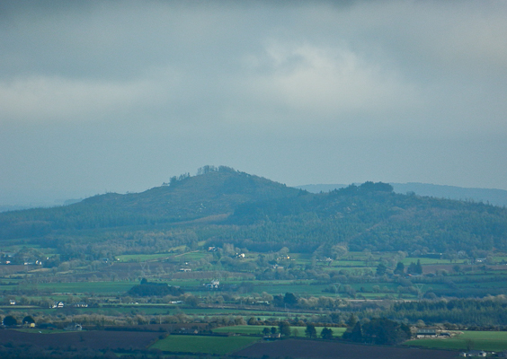
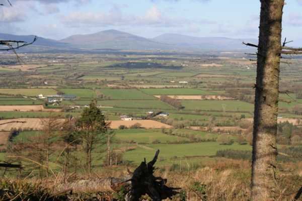
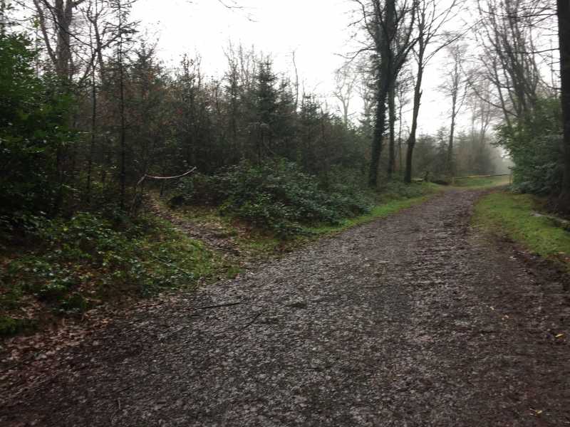
The forest tracks on the map were accurate on the ground, and I used them to reach the col between Carrickbyrnes two summits. From the car this was only a 15 minute stroll. I made a logical guess that I would find a track at the col leading to the higher summit. This proved to be the case and Im sure it prevented a lot of scrabbling about in the dense undergrowth that flourishes here. This track is narrow and there are briars and gorse with some ducking and disentangling to be done, but it will lead all the way to the ragged Wexford flag which flutters from a tree near the summit Trig Pillar. The summit is a few outcrops with tangled undergrowth and forestry below. The best views are of the Blackstairs to the North and Slievecoiltia to the SW.

Back at the col at B (S825 246) there is a track shown on the map which heads into the forestry heading just below the second summit. I followed this to add variety to the walk. I was surprised when it led to a clearing in the forest with some benches and an inscribed rock with a 1798 memorial. It read: - CAMPFIELD. In this field, also known as the Oak Grove, the United Irish Insurgents, under the command of Beauchamp Bagenal Harvey, assembled on the 4th June 1798 to prepare for the battle of New Ross -

This was interesting, not least because on Slievecoiltia a few kilometres to the SW is an inscribed stone which describes how Bagenal Harvey resigned his command on or around the 7th June a few days later!

Carrickbyrne is a pleasant little hill and there were many other Sunday strollers about. The forest tracks appear to be accurate, but there is the bonus of the unmarked trail which leads to the summit from the col. This trail wouldnt be suitable those in their Sunday best though! Linkback: mountainviews.ie/summit/1018/comment/4265/
Read Less
Read More

            MountainViews.ie picture about Carrickbyrne Hill (<em>Carraig Bhrain</em>)
Picture: Path uphill from clearing on left
Handy walk
by Kennyj 2 Jan 2016
Taking advantage of the brief respite in all the recent rain and flooding I took a quick run up and down Carrickbyrne hill,parked at the recreational area just off the N25 and followed the forest track uphill to a second car park or clearing,picked up a track heading uphill to a viewing point before following a narrow path NE all the way to the trig point at the summit,a bit overgrown in places and fairly wet following all the bad weather.Nothing to see up here today as low cloud and mist covered everything.Handy little walk up and down in 40 mins Linkback: mountainviews.ie/summit/1018/comment/18414/
Read Less
Read More

Leave the Machete at Home
by Pepe 26 Mar 2016
Met a local lady out walking her dog. She showed me an easy way up uncluttered by foliage. Park in the upper carpark and follow the forest trail off to the right. Ignore all small trails leading up left off this until you see the signpost for '98 Rebel Camp'. Turn left here. You will soon come to a fork in this path as it wends its way up and west off the main forestry trail. Veer right and arrive at the rebel camp from which I could find no way up to the top through the foliage. No worries though, the camp site is worth a goo. All you have to do then is return to that fork and take the left trail. This takes you to the summit without any need of a machete at all. Linkback: mountainviews.ie/summit/1018/comment/18473/
Read Less
Read More
EDIT Point of Interest
text
Videos
(none available)
Recent Contributions
x
Conditions and Info
Use of MountainViews is governed by conditions and a privacy policy.
Read general information about the site.
Opinions in material here are not necessarily endorsed by MountainViews.
Hillwalking is a risk sport. Information in comments, walks, shared GPS tracks or about starting places may not be accurate for example as regards safety or access permission. You are responsible for your safety and your permission to walk.
See the credits and list definitions.

OSi logo
OSNI/LPS logo
Open Street Map
(Various variations used.)
British summit data courtesy:
Database of British & Irish Hills