[RWD version 1 ]
Nowhere on earth moves me as much as my beloved West Penwith, a place unchanged since my earliest childhood, yet which is a veritable palimpsest of history. Every time I return to my Cornish homeland, I find myself irresistibly drawn to the moors of this wild and rugged peninsula, surrounded by sea, bounded by ancient stone hedges and dotted with megalithic structures. Cornwall has one of the most intensive prehistoric landscapes in Britain. And West Penwith has perhaps the highest concentration of ancient sites found in Western Europe.
Some of my bloodlines come from this place, and I feel the hand of history upon me as I ramble amid a landscape that feels undeveloped, timeless and replete with weather-worn emptiness. There are hundreds of ancient sites densely packed into this narrow peninsula, and large swathes of it have changed little since the Bronze Age. The artist and sculptor, Barbara Hepworth, who drew great inspiration from West Penwith, described it as a pagan landscape. I prefer to view it as a sacral or ceremonial one, as the route I describe through a small part of it will hopefully convey.
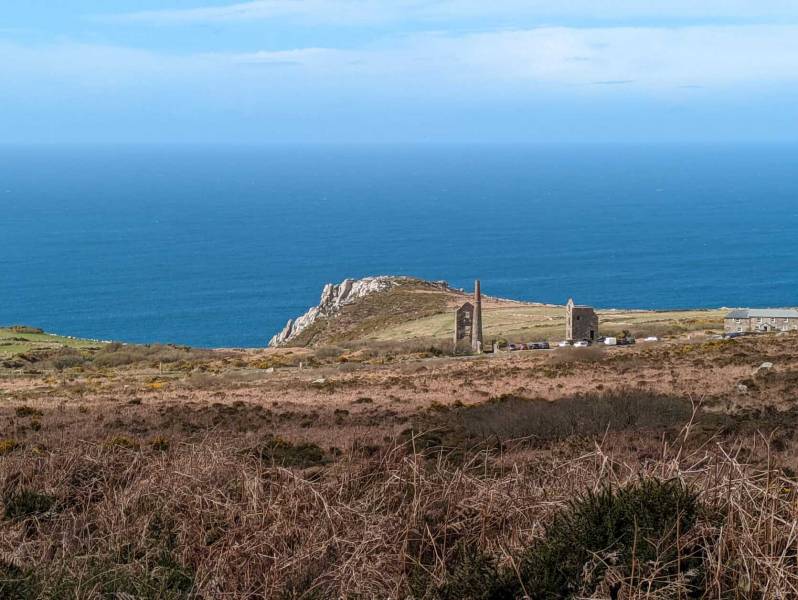
There is room for a dozen or so vehicles at the National Trust parking spot beside the nineteenth century Carn Galver mine which forms a part of the UNESCO-inscribed Cornish Mining World Heritage Site. The gaunt remains of two engine houses erected in 1871, one for pumping and one for winding, stand alongside the coast road (B3306) from St Just to St Ives. The nearby mine ‘count house’ is now a hostel for rock climbers who flock here to enjoy some of Britain’s finest cliff routes, including Commando Ridge.
We take the grassy path just to the south of the mine that winds its way up the valley between the twin hills of Carn Galver/Galva (rocky lookout in the Cornish language) and Watch Croft (Carnonbigh in Cornish). The afternoon sun enlivens the rusty-coloured bracken which sweeps up to the gnarly tor atop Carn Galva which was once a Neolithic tor enclosure with solar/lunar directional alignments. We leave the path, which is quite slippery underfoot on account of the very wet El Niño winter, and strike uphill towards the summit of Watch Croft. From its slope, the view of Carn Galver mine set against the backdrop of the rugged granite cliffs gleaming in the spring sun and the azure ocean glistening beyond, is stupendous.
Watch Croft is far less impressive than its neighbour Carn Galva, but at 23 metres higher, it is the highest point in Penwith, and one of only five Marilyn’s in Cornwall. The flattish summit covered in ‘browse’ (bracken, gorse and heather), is marked by a trig point atop a despoiled Bronze Age cairn. Nearby is a second collapsed cairn, and a menhir is situated just downhill to the south. On the hill’s north-western slopes are the remains of a couple of hut circles dating to the Iron Age.
The views from the summit are extensive and include Pendeen Watch (lighthouse), the stacks and engine houses of Geevor and Levant mines, and the truncated remains of the engine house of Morvah Hill tin mine to the west. To the north are the rocky tors atop Carn Galver, and to the southeast, Boskednan Moor (from the Cornish ‘Boskennan’ first recorded in 1310), with the engine house at Ding Dong Mine riding the horizon.
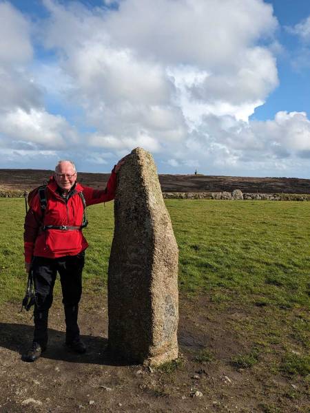
We descend the hill over White Downs along a very overgrown footpath making towards the Mên-Scryfa (Cornish for inscribed stone), which involves climbing over a Cornish hedge. This granite menhir, which stands alone in a field, is probably a repurposed prehistoric megalith which was inscribed on its northern side in the late Iron Age/Celtic period (5th or 6th century AD) with the words “Rialobrani Cunovali fili,” which translates as “Rialobranus son of Cunovalus.” This is a Latinised form of Cornish, and means ‘Royal Raven, son of the famous leader’. It was thus a memorial stone to the son of a tribal leader of an Iron Age clan or tribe, whose name was taken from Bran, a mythical Celtic god or chieftain. As the inscription is on the north face of the stone, it is best viewed in the setting sun during the summer. The stone was re-erected twice in the nineteenth century, and the ‘fili’ part of the inscription is now concealed in the ground.
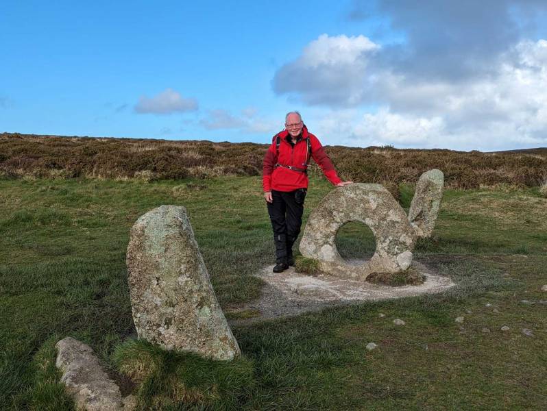
From Mên-Scryfa we pass over a granite stile onto a trackway which leads from Bosullow Common up onto Boskednan Moor. Heading south east, we arrive at another stile which takes us onto a grassy pathway leading to the Mên-an-Tol (Cornish for ‘Stone of the Hole’). This centrepiece of this enigmatic structure is a granite stone 4ft (1.2m) across with a 20-inch (51cm) round hole, large enough for an adult to crawl through. Either side of it are two 4.5ft (1.3m) high upright stones and another fallen one. Around the edge of the monument are the visible remains of other stones, leading to the assumption that the site was formerly a stone circle. It is thought that this originally consisted of nineteen stones, in common with many of the other stone circles in West Penwith.
The site probably dates from the late Neolithic-early Bronze Age (approx. 2500-1500 BC) as do the other stone circles in West Penwith, and was undoubtedly used for ritual and ceremonial purposes. Indeed, the closeness of holed stones to stone circles is recorded at other places, including Tregeseal stone circle near the town of St Just in Penwith, and the Stone of Odin that formerly stood between two stone circles on the mainland of Orkney, Scotland. Such stones might have been used either as entrance portals to a barrow, or to give sightlines to other monuments, and/or to the sun and moon. If the Mên-an-Tol had originally been erected at right angles to its present position, it could have been used by our ancient ancestors to view the rising moon at its most northerly extreme (which only occurs every 18.6 years). Seen from the centre of the circle, the moon would have been framed perfectly by the hole.
Unsurprisingly, the Mên-an-Tol has long been the subject of legends relating to healing and divination. Also known as the Crick stone, it was thought that to crawl through the hole nine times widdershins (against the sun or anti-clockwise) was a cure for backache, rickets and scrofula. Like every Cornish child, I loved clambering through the stone whenever I visited the site. The landscape hereabouts is literally crammed with megalithic monuments, including Lanyon Quoit, which can be seen in a field to the SSE.
From the Mên-an-Tol we head across a damp and boggy Boskednan Moor, serenaded by the sound of the first skylark of spring. The ground is very waterlogged where two small streams have to be crossed. A series of vegetated hummocks and shallow depressions to the southwest of the path betray the presence of a series of costeen pits, excavated by miners to test the strike of a mineral lode. This is a reminder that although we are passing through a landscape that now feels wild and empty, it was once, as in the prehistoric period, a busy haven of activity.
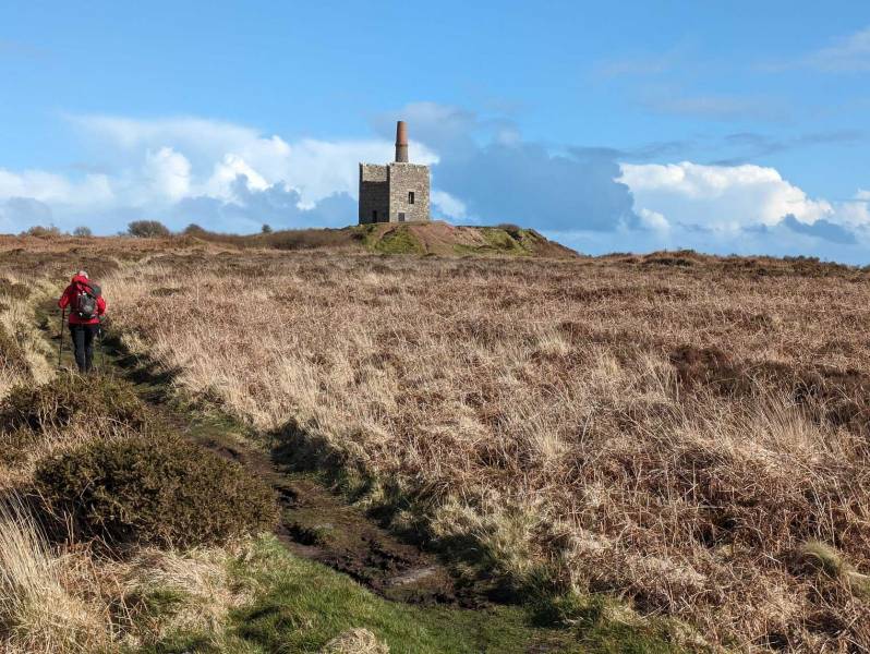
Ahead looms the Greenburrow engine house, erected in 1865 to pump water from the workings of Ding Dong Mine. This mine, a part of the Cornish Mining World Heritage Site, is one of Cornwall’s oldest, and legend has it that it was worked for tin in Biblical times. It was certainly working in the very early eighteenth century and was the site of a real ‘ding dong’ in 1797, when famous Cornish engineer, Richard Trevithick, was accused by James Watt of infringing the Boulton and Watt patent during the installation of a 28-inch cylinder inverted steam engine designed by Edward Bull. Agents from Boulton and Watt turned up at the mine to demand its removal, which riled Trevithick to the point whereby he picked up a 12lb sledge-hammer which he hurled right over the roof of the engine house. This display of strength intimidated the agents who promptly left the mine.
The view from the engine house is remarkable. Away to the east, the pyramidal tidal island of St Michael’s Mount with its Gothic granite-built castle, rises majestically from Mount’s Bay, while to the north, the granite of Ishmael’s Whim Engine House positively glows in the rays of the spring sunshine. I sit awhile to take in the vastness of the moor with its granite tors erupting from the rusty bracken, coloured with the first saffron-yellow blooms of gorse. Cheek by jowl with these gnarly natural masterpieces, the granite of farmhouse, engine house and megalith stands bravely against the endless westerlies that sweep in from the restless Atlantic. Man’s hand has transformed this landscape, but over time nature has beaten these structures into submission. The engine houses are unroofed and a haven for nesting birds; the hard edges of the granite walls of the farm-buildings, some abandoned, have been softened by the wind and rain; and the megaliths are hoary with lichens.
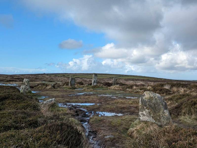
From Greenburrow engine house we strike out across the windswept, lonely moor towards Boskednan stone circle, colloquially known as the Nine Maidens. The ground is very rough underfoot and the area near the circle is swimming in at least an inch of water. The circle is thought to date to the Early Bronze Age. Cornish Antiquarian, William Borlase, noted in the mid-eighteenth century that there were nineteen stones, thirteen of which were standing, with another six laying in position close to where they had fallen within the 22-metre diameter ring. Today there are nine, and two fallen stones. It is believed that the site might originally have had as many as twenty-two megaliths, but these have been robbed by farmers and miners over the centuries. On the southern edge of the circle and slightly encroaching on it, is a small round barrow that has been despoiled.
That this monument forms a part of a larger ceremonial landscape is immediately evident. The Mên-an-Tol is only 800 metres to the west, and just over a mile (1.7 kilometres) away across the valley to the east is the Iron Age settlement of Bodrifty, while Mulfra Hill and its Neolithic chambered tomb with collapsed capstone stands at a similar elevation to the circle, at around 220 metres above sea level. The distant hills dominate the landscape at Boskednan. They sweep round in an arc from Boswens Common in the southwest to Chûn Downs with its Iron Age hillfort and chambered tomb of Chûn Quoit, then on to Carn Downs to the west and round to Watch Croft and the rocky tor of Carn Galva which looms on the horizon to the northwest. The majority of the stones on site are around one metre in height. However, three stones on the northern edge of the circle are considerably taller, at almost two metres. Interestingly, these line up with Carn Galva, which undoubtedly had some significance in this ceremonial landscape.
It is towards Carn Galva that we now head, along a clearly defined trackway passing the Four Parishes Stones, a collapsed granite megalith with an inscribed cross that lies at the point where the parishes of Zennor, Morvah, Madron and Gulval meet. The track heads back to the saddle between Carn Galva and Watch Croft where we pick up the path back down to Carn Galver car park after a thoroughly enjoyable ramble.
For me, this landscape with its monuments to our ancestors, symbols of their engineering prowess, creativity and devotion, possesses a deep spirituality. Even the more recent mining monuments that were once symbolic of mass destruction have found a home within it, as symbols of Cornish engineering ingenuity and skill. And like the megalithic structures wrought from the local granite thousands of years before, the roofless mine engine houses are now engaged in an endless dance between deliberate sculpture and organic natural erosion at the hands of Mother Nature.


 Our Facebook page.