This website uses cookies, which are small text files that the website puts on your device to facilitate operation. Cookies help us provide a better service to you. They are used to track general user traffic information and to help the website function properly.
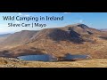
nupat: Track/5063 in area near Nephin Begs (Ireland)
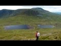
Great option for a day hike over Slieve Carr (inspired by Irish Peaks)
Ascent: 761m,
Length: 18.8km,
Creator time taken: 6h59m
Descent: 790m,
Time predicted from Naismith's rule: 5h 1m + breaks
Click here to rate track
PlacesStart at F85732 15311, Slieve Carr, Tawnyanruddia, end at Start
Track Rating ..
[RWD version 1 ]
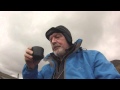
We followed the excellent waypoints listed in "Irish Peaks" to reach the summit of Slieve Carr. We took an alternative, higher option on the way home which we would recommend.
Editing Details for track/5063
NOTE: ALL information such as Ascent, Length and Creator time taken etc should be regarded as approximate. The creator's comments are opinions and may not be accurate or still correct.
Your time to complete will depend on the speed of the slowest plus break time and your mode of transport.
NOTE: It is up to you to ensure that your route is appropriate for you and your party to follow bearing in mind all factors such as safety, weather conditions, experience and access permission.
Uploaded on: Wed, 10 Apr 2024 (13:45:12), Linkback: https://mountainviews.ie/track/5063/
* Note: A GPS Height in the elevation profile is sourced from the device that recorded the track. An "SRTM" height is derived from a model of elevations for parts of the earth. More detail
Use of MountainViews is governed by conditions and a privacy policy.
Read general information about the site. Opinions in material here are not necessarily endorsed by MountainViews.
Hillwalking is a risk sport. Information in comments, walks, shared GPS tracks or about starting places may
not be accurate for example as regards safety or access permission. You are responsible for your safety and your permission to walk.
See the credits and list definitions.


 Our Facebook page.