This website uses cookies, which are small text files that the website puts on your device to facilitate operation. Cookies help us provide a better service to you. They are used to track general user traffic information and to help the website function properly.
Feature count in area: 14, all in Wexford,
OSI/LPS Maps: 61, 62, 68, 69, 76, 77, EW-B, EW-B
Highest Place: Slieveboy 420m
Starting Places (16) in area Wexford: Askamore Cemetery, Ballymore Wood, Clone Strand, Clonegal, Coolmelagh Forest CP, Cummer Wood South, Gibbet Hill West, Mary Neal's Spout, Mount St Benedict's School, R746 Half Way House, Scroughmore Cross W, Slieveboy NE, Slieveboy SE, St John's Church, Tarahill House, Vinegar Hill
Summits & other features in area Wexford: N: Bunclody: Kilmichael Hill 269.3m N: Bunclody : Gibbet Hill 315m, Kilcullen Hill 218m, Slieveboy 420m N: Enniscorthy : Oulart Hill 179m, Vinegar Hill 116.6m NE: Wexford East : Carrigroe Hill 232m, Tara Hill 253m S: Wexford South: Bree Hill 179m, Camaross Hill 181m, Forth Mountain 237m SW: New Ross Hills : Carrickbyrne Hill 233m, Lacken Hill 193m, Slievecoiltia 268.5m
Note: this list of places may include island features such as summits, but not
islands as such.
Tara Hill, 253mHill Torrchoill A name in Irish,
Place Rating ..
(Ir. Torrchoill [logainm.ie], 'tor-wood') Fordrum an extra name in English, Wexford County in Leinster province, in Binnion Lists, Tara Hill is the 1276th highest place in Ireland. Tara Hill is the most easterly summit and also the second most northerly in the Wexford area.
Grid Reference T20535 62332,
OS 1:50k mapsheet 62 Place visited by: 68members, recently by: childminder05, mickhanney, MartaD, Jonesykid, Pepe, SenanFoley, pinchy, arthurdoylephoto, loftyobrien, oreills8, Cormacg, eugeneryan959, Aciddrinker, simoburn, JoHeaney
I visited this place: NO (You need to be a logged-in member for this.)
Longitude: -6.217719, Latitude: 52.69912, Easting: 320535, Northing: 162332,
Prominence: 198m, Isolation: 10.8km, Has trig pillar
ITM: 720460 662378 Bedrock type: Felsic volcanics, (Campile Formation) Notes on name: Contrary to appearances this name has nothing to do with the word Teamhair that occurs in Tara, Co. Meath, nor even with the Eng. word 'hill'. Name Fordrum noted on Wexford Coastal Path display.
Short or GPS IDs, 6 char: TrHl, 10 char: Tara Hill Linkback: https://mountainviews.ie/summit/998/
Gallery for Tara Hill (Torrchoill) and surrounds
Summary
for Tara Hill (Torrchoill):
Coastal Views though lots of wood.
Summary created by JohnA, simon3, wicklore
2022-01-02 16:59:23
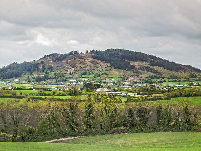
Picture: Tara Hill, Wexford from the North
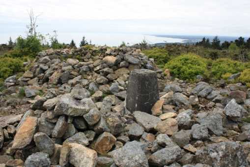
There is space for 1 car to park at a gate without blocking it at A (T20701 61962). From here a nice track leads up through the trees and it is easy to use a couple of tracks to find the trig pillar and remains of a cairn at the summit. Ignore a reference to the ‘Green Link’ route on the waymarker post unless you have read an information board on a nearby road on the way to the starting point.
Gorey, Courtown and other villages of the North Wexford coast are visible from the summit, and there is a nice view out across the Irish Sea.
Tara Hill presents as a lovely rounded hill standing alone on the south east coast near Gorey. I explored the roads surrounding it and made the mistake of driving along the “other road” marked on the map between the graveyard at Kilcavan and Ballincarrig – this looked like a handy short cut but at times is little more than a dirt track, too narrow even for a car. However I made it and found a lovely starting point on a narrow leafy country road at A (T20701 61962). There is a double gate leading into a field and it’s possible to park a car here without blocking access. There is a track heading up the hill at this spot, and it is marked by a wooden pole with a red arrow on it. The enigmatic words “Summit, connects walk via green link” are on a little plaque on the pole. I followed this delightful track through the trees all the way to the summit. It is narrow at times and it is necessary to either climb over or duck under fallen trees in places. The narrow track crosses a wide forestry track after a few minutes, and evidence of horse riding starts to show everywhere. A few more minutes brings you out onto the summit cairn and trig pillar at B (T205 623). The cairn has been dismantled to create a modern circular shelter, but the trig pillar retains one of those curious benchmark plaques that pdtempan discusses in Motley Views General Forum (04-06-2008). The summit has suffered some throwing away of wrappers and drink cans. I’d say it was children due to the child-oriented nature of the said wrappers and containers – but I could be proven wrong if any adult comes forward and says “that wasn’t a child who threw that, it was me…” I was expecting the hill to be completely covered in forestry but the summit is somewhat clear, giving views to the south, east(across the sea) and north. There is a great view of Croghan Kinsella to the north. On leaving Tara Hill I came across an information board on a nearby road that described various routes around Tara Hill. I had missed it due to my earlier short-cut journey along the narrow track in my car. The routes are guided by coloured arrows on wooden poles-at least the mysterious “green link” message from the pole earlier was now explained! Linkback: mountainviews.ie/summit/998/comment/3757/
Read Less
Read More
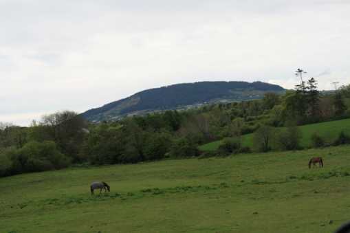
Picture: Two horses and a hill
wicklore on Tara Hill
by wicklore
17 May 2009
Although only 253 metres high, Tara Hill dominates the landscape of northeast Wexford. This is due to its height relative to the surrounding landscape. Tara Hill stands alone and presents as a lovely rounded hill, easily visible to those travelling on the N11 near Gorey. Saint Caemhan, or Kevin, is the Patron Saint of Tara Hill and the site of the old church founded by him is situated at Kilcavan at the north side of the hill under a cliff by the road. Tara Hill is over 400 million years old and was formed from molten rock. During the Ice Age the hill was buried under a huge sheet of ice which resulted in its rounded appearance. The soil on the upper parts is shallow and acidic but allows for growth of heather and furze. The hill has also been widely planted with conifers by Coillte. However the summit is clear allowing views in most directions. (but not to the west) The summit is marked by a cairn from where one can see nearby Gorey, Courtown and other villages of the North Wexford coast. It appears to be well used by walkers and horse riders, but thankfully no evidence of quads! Linkback: mountainviews.ie/summit/998/comment/3758/
Read Less
Read More
Pleasant walk on a Saturday afternoon
by hibby
10 Oct 2010
There is an extensive network of walking routes mapped and colour-coded around the hill, as shown on an information board at the roadside. Unfortunately, in the absence of a photographic memory or a paper copy to carry with you on the walk, this is of limited use.
After some initial difficulty in finding our way to Point A (we didn't have the local Discovery map and Garmin didn't know about the existence of the road) we parked at the suggested spot and followed the red route into the woods. The initial woodland section of the walk was quite picturesque. A short time later (having crossed the stony forest track on the way up) we emerged from the forest into the open area around the summit. The summit is somewhat indistinct but marked by the cairn and trig point (which unusually has a plaque inscribed with the benchmark symbol and the letters and numbers OSBM 0012). Although it was a warm day, visibility was poor in persistent mist and haze, and the views from the summit were disappointing.
The path by which we approached the summit was narrow and involved pushing our way between gorse and bramble. However on the descent we followed a wider and more congenial path down to the west (the yellow route) which led us around to the stony track. Following this down on the north-east side of the hill, we picked up the red route again, which brought us back to the road and the car. Linkback: mountainviews.ie/summit/998/comment/6131/
Read Less
Read More
Narrow Road but worth a Visit
by Pepe
11 Jun 2023
Followed wicklore’s instructions and parked at the double-gate. Mind you, it’s a very slender boreen that leads to that gate – it would not do to meet anything coming the other way (I was so preoccupied with the narrowness of the road I failed to notice the carpark at the foot of the hill).
Just opposite that aforementioned double-gate is a little red sign declaring ‘Mary Neale’s Spout’ marking a hillside spring. From here a delightful narrow trail leads you more or less directly up. You’ll be to the cairn and back at your car in under half an hour. Linkback: mountainviews.ie/summit/998/comment/23982/
Use of MountainViews is governed by conditions and a privacy policy.
Read general information about the site. Opinions in material here are not necessarily endorsed by MountainViews.
Hillwalking is a risk sport. Information in comments, walks, shared GPS tracks or about starting places may
not be accurate for example as regards safety or access permission. You are responsible for your safety and your permission to walk.
See the credits and list definitions.


 Our Facebook page.