This website uses cookies, which are small text files that the website puts on your device to facilitate operation. Cookies help us provide a better service to you. They are used to track general user traffic information and to help the website function properly.
Feature count in area: 57, by county: Cork: 32, Kerry: 36, of which 11 are in both Cork and Kerry,
OSI/LPS Maps: 83, 84, 85, 88
Highest Place: Hungry Hill 682m
Starting Places (51) in area Caha Mountains: Ardgroom, Barley Lake North, Bere Island Pier, Caha Pass, Canshanavoe South, Carriganine, Cashelkeelty Stone Circles Carpark, Castletownbere Lifeboat Harbour, Clashduff River Farm, Coolieragh Harbour Road, Coomadayallig Lake Road N, Coomadayallig Lake Road S, Cooryeen Lane, Cummer Lough East Road, Derreenataggart Stone Circle Road, Dromoghty Lough North, Dunboy Wood, Esk Boreen, Eyeries, Fehanah Lane, Garinish Island Pier, Glantrasna Bridge, Glenbeg Lough N, Glengarriff, Glengarriff Nature Reserve CP, Gleninchaquin Waterfall, Gowlaun Lough, Healy Pass, Healy Pass Hairpin, Ilnacullin Car Park, Kenmare Bridge, Knockacullin Lane, Leahill Bog, Leitrim Beg Standing Stone, Lough Inchiquin SE, Magannagan Stream, Molly Gallivan's Visitor Centre, Nora's Cottage, Old Lansdowne School, Owgarriff River Lane, Peg's Shop, Pooleen Wood Car Park, Red Trout Lake, Reenroe Bridge, River Drimminboy Track, Rossmackowen Bridge, Rossmackowen Cemetery, Shronebirrane Farm, Shronebirrane Road, Toberbanaha, Turner's Rock Tunnel
Summits & other features in area Caha Mountains: Cen: Hungry Hill: Coombane 510m, Derryclancy 554m, Hungry Hill 682m Cen: Knockowen: Cushnaficulla 594m, Glenkeel Top 417m, Knockastumpa 398m, Knockeirky 577m, Knockeirky South Top 523m, Knockowen 658m, Stookeennalackareha 412m E: Glengarriff: Derrynafulla SW 375m, Gowlbeg Mountain 362m, Nareera 530m, Nareera North Top 503m, Nareera South-West Top 505m, Shrone Hill 283m, Sugarloaf Mountain 574m, Sugarloaf Mountain Far West Top 560m, Sugarloaf Mountain West Top 565m N: Coomnadiha: Baurearagh Mountain 489m, Caha Far SE Top 555m, Caha SE Top 585m, Coomnadiha 644m, Coomnalack Top 435m, Cummeenbaun 510m, Droppa 522m, Killane Mountain 537m, Killane Mountain South-West Top 533m, Knockagarrane 414m, Knockreagh 500m N: Knockeirka: Barraduff Mountain 400m, Killaha Mountain 400m, Knockeirka 426m N: Knocknagorraveela: Derrysallagh 410m, Feorus East 474m, Knocknagorraveela 507m, Knocknagorraveela NE Top 464m N: Lauragh: Knockanoughanish 386m, Knockatee 330m S: Castletownbere: Disert 205m, Knockanallig (Bear Island) 267m W: Ardgroom: Derryvour Hill 160m W: Eskatarriff: Coomacloghane 599m, Eskatarriff 600.5m, Eskatarriff East Top 532.7m, Knocknaveacal North Top 509.1m, Knocknaveacal South Top 507.2m, Lackabane 603m, Tooreenbaha 408.7m, Tooreennamna 524m, Tooth Mountain 592m W: Knocknagree: Knocknagree 586m, Knocknagree East Top 461m, Knocknagree SE Top 442m, Lackawee 572m, Maulin 621m, Maulin North Top 579m
Note: this list of places may include island features such as summits, but not
islands as such.
Knockatee, 330mHill Cnoc an Tí A name in Irish,
Place Rating ..
(Ir. Cnoc an Tí [logainm.ie], 'hill of the house'), Kerry County in Munster province, in Binnion Lists, Knockatee is the 1098th highest place in Ireland.
Grid Reference V77500 60400,
OS 1:50k mapsheet 84 Place visited by: 38members, recently by: Superterence, jlk, chelman7, learykid, bandre, Fergalh, daitho9, eamonoc, GoldCircle, Wildrover, FrankMc1964, davsheen, markmjcampion, jgdarcy, Corkerry
I visited this place: NO (You need to be a logged-in member for this.)
Longitude: -9.775837, Latitude: 51.783048, Easting: 77500, Northing: 60400,
Prominence: 175m, Isolation: 2.6km ITM: 477476 560464 Bedrock type: Green-grey sandstone & purple siltstone, (Gun Point Formation) Notes on name: The name probably refers to Derreen House, located to the south of this hill near Lauragh. This interpretation seems preferable to Cnoc an tSí, 'hill of the fairy-mound', given in some sources.
Short or GPS IDs, 6 char: Knc330, 10 char: Knockat330 Linkback: https://mountainviews.ie/summit/924/
Gallery for Knockatee (Cnoc an Tí) and surrounds
Summary
for Knockatee (Cnoc an Tí):
Small hill with a massive view.
Summary created by simon3
2020-08-16 16:53:13
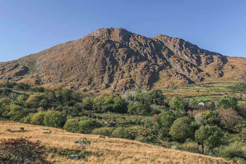
Picture: Knockatee, the rough NW side.
An obvious place to visit this from is the col at A (V78101 60093). There is parking for 2 or 3 cars. The ground is unfenced and the land leading to the top is rough but passable.
Knockatee is well known in the area both for its distinctive shape and as a pleasant place to visit. It is commonage and actively used by local sheep farmers.
Views from the top include the intricate coastline to the SW of Kilmakilloge Harbour over which there is the ridgeline of the Cummeegeera Circuit. Across Kenmare River much of the famous high ground of the Dunkerrons is visible such as Mullaghanattin and the MacGillycuddy Reeks.
Visit this place on a good day for a quick walk with all that is best in Kerry and Cork views.
On the minor road between Knockatee and Knockanoughanish, there is enough space to park a car off road on small track, without blocking it, at L Gowlán (V78175 60165).
Follow the track up hill and then sheep tracks, after it ends. You are aiming for the large re entrant / rock faulty, which runs left to right across the hill. Once in this grassy re entrant, ascend it (right) to its highest point. Look to your left and you will see a faint path leading up hill to the small summit area. And what a view point it is! Linkback: mountainviews.ie/summit/924/comment/6000/
Read Less
Read More
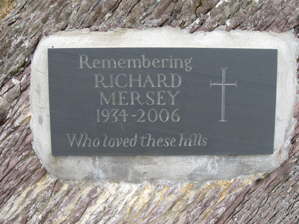
Picture: Memorial plaque
Author of one of Ireland's best hillwalking books remembered
by madfrankie
15 May 2017
At a mere 330m Knockatee has a lowly elevation that belies it's ruggedness and stature.
From the road that crosses the col with Knockanoughanish it's a steep but brief pull up stone-strewn slopes. The summit lacks a cairn or pile of stones, but just below the summit is a plaque set into a boulder, a memorial to Richard Mersey, author of 'The Hills of Cork & Kerry'. Linkback: mountainviews.ie/summit/924/comment/6449/
Read Less
Read More
Small but Perfectly Formed. Excellent Views for the Effort.
by ciarraioch
7 Aug 2020
Might be a nice one for the family on a dry day or an easy introduction to the hills for casual walkers. Climbed on a cloudy and drizzly February afternoon from the road on the saddle between Cnoc a' Ti and Cnoc an Uaignis. Had a lash at the latter as well (see separate entry) , although that was a much longer affair. Between the combings of cloud, excellent views onto Lauragh & Kilmackilogue and the Cummeengeera Horseshoe as well as across the bay down towards Caherdaniel. The poignant monument at the summit to Richard Mersey is a fitting tribute on the very first hill he climbed back in the '40s. Richard in his book 'The Hills of Cork and Kerry', captured as no other the sentiments of those of us who love this glorious corner of the world. Go ndeanfaidh Dia trocaire ar a anam uasal. [ Please be aware that another post refers to a different view of Richard Mersey's character ] Linkback: mountainviews.ie/summit/924/comment/6562/
Read Less
Read More
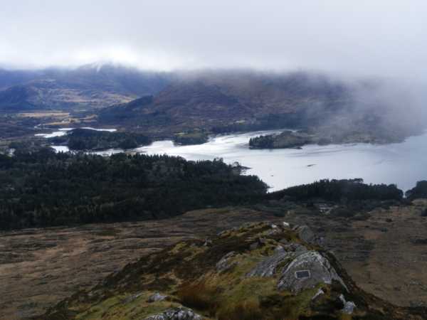
Picture: Knockatee from the SW.
Fairy in the sunshine.
by simon3
10 Jun 2013
Just to complement the sentiments expressed so eloquently by others such as ciarraioch, this photo shows Knockatee on a sunny day in June, taken from the SW. Linkback: mountainviews.ie/summit/924/comment/15015/
Read Less
Read More
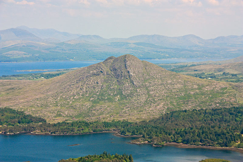
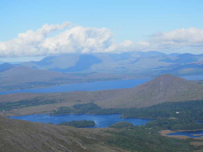
Picture: Knockatee from Lackabane / Rabbachs glen walk
Beara Views
by davsheen
1 Jan 2017
View from Lackabane on the Rabbachs Glen walk looking towards Knockatee and the Ivearagh Peninsula and Kenmare river in the background. Linkback: mountainviews.ie/summit/924/comment/18763/
Use of MountainViews is governed by conditions and a privacy policy.
Read general information about the site. Opinions in material here are not necessarily endorsed by MountainViews.
Hillwalking is a risk sport. Information in comments, walks, shared GPS tracks or about starting places may
not be accurate for example as regards safety or access permission. You are responsible for your safety and your permission to walk.
See the credits and list definitions.


 Our Facebook page.