This website uses cookies, which are small text files that the website puts on your device to facilitate operation. Cookies help us provide a better service to you. They are used to track general user traffic information and to help the website function properly.
Feature count in area: 5, all in Limerick,
OSI/LPS Maps: 64, 65, 72, 73
Highest Place: Knockanimpaha 344m
Starting Places (4) in area West Limerick: Ballingarry, Dairy Well, Knockfeerina Lane, Rathcahill Wind Farm
Summits & other features in area West Limerick: E: Ballingarry: Ballyea Hill 214m, Corronoher 272.1m, Knockfeerina 288m S: Templeglantine: Glenmore Hill 292m W: Newcastle West: Knockanimpaha 344m
Note: this list of places may include island features such as summits, but not
islands as such.
Knockanimpaha, 344mHill
Place Rating ..
, Limerick County in Munster province, in Binnion Lists, Knockanimpaha is the highest hill in the West Limerick area and the 1068th highest in Ireland. Knockanimpaha is the most westerly in the West Limerick area.
Grid Reference R21630 34628,
OS 1:50k mapsheet 64 Place visited by: 23members, recently by: Krzysztof_K, annem, Taisce, chelman7, maryblewitt, JohnRea, FrankMc1964, Fergalh, conormcbandon, chalky, eamonoc, frankmc04, hivisibility, paddyhillsbagger, acorn
I visited this place: NO (You need to be a logged-in member for this.)
Longitude: -9.153364, Latitude: 52.45771, Easting: 121630, Northing: 134628,
Prominence: 159m, Isolation: 7.5km, Has trig pillar
ITM: 521615 634654 Bedrock type: Sandstone, siltstone & mudstone, (Central Clare Group) Notes on name: The second element in this name appears to be derived from the verb iompaím. It may be iompú, gen. iompaithe, giving the meaning 'hill of the turning or retreat'. Alternatively, it may be iompaithe, 'turned, converted', in which case the sense is 'hill of the converted (person)'.
Short or GPS IDs, 6 char: Knc344, 10 char: Kncknmph Linkback: https://mountainviews.ie/summit/907/
Gallery for Knockanimpaha and surrounds
Summary
for Knockanimpaha :
Easy to reach, views middling.
Summary created by simon3, jackill
2012-02-06 11:31:59
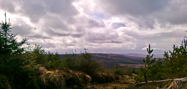
Picture: Looking west to windmills
From Newcastle West take the N21 for Abbeyfeale turning right uphill at Garryduff about 5 kms from Newcastle West.
Make your way to the turn at A (R21044 34705) to a forest entrance. The public road system is extremely confusing but is well shown on OSi maps.
Walk east, cross a berm and find a recessed track and follow this through the forest area (clear felled as of 2012). Make one right turn off this nearing the top (B (R2151 3474)) and get to the trig pillar.
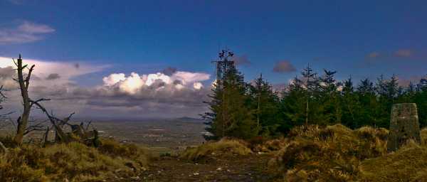
There would also be other easy routes up from the north and particularly to the east of the summit going beside a telecoms mast there.
Good view across plains towards Limerick , Mullaghareirk Mountains behind but not towards the south.
Park at mast entrance C (R21756 34580) walk down hill to edge of security fence cross over up track to summit trig at D (R21648 34606).......up and down in 8 Linkback: mountainviews.ie/summit/907/comment/6809/
Read Less
Read More
Picture: Looking east to Knockfeerina
jackill on Knockanimpaha
by jackill
1 Apr 2010
I happened to be passing through Newcastle West at lunchtime today and instead of a chicken sandwich I had a mountain.I was lucky to have a pair of wellingtons in the car boot and so the stage was set for the conquest of mighty Knockanimpaha! In truth it was almost too easy.I had an idea from the OSI aerial photos that the summit was covered in trees, but as of 2010 it isn't. I parked just off the road at E (R20942 34389) and went straight across the felled trees and onto a track after 200 meters, I turned right and then left and kept going uphill until I arrived next to the Trig pillar.Good view across plains towards Limerick with windmills and the Mullaghareirk Mountains behind. If you're passing give it 20 minutes, well worth the effort Linkback: mountainviews.ie/summit/907/comment/4566/
Use of MountainViews is governed by conditions and a privacy policy.
Read general information about the site. Opinions in material here are not necessarily endorsed by MountainViews.
Hillwalking is a risk sport. Information in comments, walks, shared GPS tracks or about starting places may
not be accurate for example as regards safety or access permission. You are responsible for your safety and your permission to walk.
See the credits and list definitions.


 Our Facebook page.