Guestuser: Login or enrol?
- Home
- Main Display
- Main Display (Old)
- Find a Walk
- Display INTRODUCTION
- DONATE
- Click below for your
profile & contributions
guestuser- New
- Tracks, Walks
- Challenge
- Community
- Lists & Logs
- Popular Lists:
- County Highpoints
- Range & Area Highpoints
- Local 100
- Highest Hundred
- Vandeleur-Lynams
- Arderins
- Carns
- Best rated
- Irish 900 up
- Irish Island
- Munros
- All Lists
- Shorter Irish
- County Highpoints
- Range & Area Highpoints
- Highest Hundred
- Local 100
- Local 100 (pre2014)
- Local Historical Cultural
- Best rated
- Irish 900 up
- Larger Irish
- Arderins
- Arderin Begs
- Arderins + Arderin Begs
- Vandeleur-Lynams
- Vandeleur-Lynams + Arderins
- Carns
- Binnions
- Highest 50 per Province
- Island Features
- Irish Island
- Coastal Hills
- Irish 600 up
- Irish 500 up
- British
- Munros
- British 600 up
- British 500-600
- British Marilyns
- Comprehensive
- All Irish summits
- All Irish features
- All British summits
- All Britain+ Ireland
- Special
- Analysis List
- Simple Irish Listings
- Simple Irish & British Listings
-
- More
- Motley Views
Welcome to MountainViews
If you want to use the website often please enrol (quick and free) at top right.OverviewFor more map options click on any overview map area or any detail map feature.Detail Map FeaturesFind Suggested Walks
Find hill, mountain, island, coastal feature.Videos


Recent Contributions
 Get Notifications
Milane Hill: Not inviting but OK
Slievemore: Less prickly from North
Long trail to rewarding tops.
Knocknagree East Top: Fine top with good access mostly on trail
Very fine Carn with stunning views.
Steep ascent, stunning views
Mount Gabriel: Simple and stunning
GR 92: Estartit to l'Escala
Coomnalack Top: Lacks for nothing
Little Bin: Tough little climb
GR 92: Roses to Cadaques
Silvermines Hydro Project
Conditions and Info
Use of MountainViews is governed by conditions and a privacy policy.
Read general information about the site.
Opinions in material here are not necessarily endorsed by MountainViews.
Hillwalking is a risk sport. Information in comments, walks, shared GPS tracks or about starting places may not be accurate for example as regards safety or access permission. You are responsible for your safety and your permission to walk.
See the credits and list definitions.Video displayTwelve Bens Area E: Glencorbet SubareaPlace count in area: 34, OSI/LPS Maps: 37, 44, EW-CON, MSW
Highest place: Benbaun, 729m
Maximum height for area: 729 metres, Maximum prominence for area: 684 metres,
Places in area Twelve Bens:
Cen: Lough Auna Hills:Cregg 297mTownaloughra East Top 216m
Cen: Polladirk:Bencullagh 632mMaumonght SW Top 454mDiamond Hill 442mKnockbrack 442mMaumonght 602m
E: Glencorbet:Benbaun 729mBenbrack 582mBenbaun 477mKnockpasheemore 412mBenfree 638mMuckanaght 654m
N: Doughruagh:Altnagaighera 549mBenchoona 581mBenchoona East Top 585mCurrywongaun 273mDoughruagh 526mDoughruagh South Top 525mGarraun 598mGarraun South Top 557mLetterettrin 333m
SE: Glencoaghan Loop:Bencollaghduff 696mBenglenisky 516mBenlettery 577mBencorr 711mBencorr North Top 690mBencorrbeg 577mBinn an tSaighdiúra 653mBenbreen 691mBenbreen Central Top 680mBenbreen North Top 674mDerryclare 677mBengower 664m
Note: this list of places includes island features such as summits, but not islands as such.
(Ir. An Bhinn Bhán [logainm.ie], 'white peak') County Highpoint of Galway in Connacht Province, in County Highpoint, Arderin, Vandeleur-Lynam, Irish Highest Hundred Lists, Pale quartzites, grits, graphitic Bedrock
Height: 729m OS 1:50k Mapsheet: 37 Grid Reference: L78558 53903
Place visited by 661 members. Recently by: thmswhelan, Clionaodriscoll, MartMc, Jimmel357, Blackstar, ryanguinness10, Miriamowens, agakilbride, Josephineobrien, hikingofireland, orlaithfitz, knightsonhikes, rosduke, sineadh, claireod5I have visited this place: NO (You need to be a logged-in member to change this.)Longitude: -9.831791, Latitude: 53.521228 , Easting: 78558, Northing: 253903 Prominence: 684m, Isolation: 0.9km, Has trig pillar
ITM: 478532 753923 , GPS IDs, 6 char: Bnbn, 10 char: Benbaun
Bedrock type: Pale quartzites, grits, graphitic, (Bennabeola Quartzite Formation)
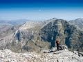
An Bihnn Bhán means 'the white peak' and is the highest mountain in Galway. You could say it is the Mont Blanc of Connemara. There is a lot of white rock here, mainly quartz, though this is more a feature of Benbrack. An odd thing about the Twelve Bens of Connemara is that nobody seems to know exactly which are the twelve peaks in question. There are at least 20 peaks with names in binn in this area. However, the notion of twelve peaks goes back at least to the time of Roderic O'Flaherty, who wrote in 1684 of the twelve high mountaines of Bennabeola, though he did not enumerate them (O'Flaherty, 106). In Irish the question doesn't even arise: there is no number, they are just na Beanna Beola, 'the peaks of Beola'. Beola was a giant and chieftain of the Fir Bolg, whose name also features in the village Tuaim Beola (Toombeola). An Bhinn Bhán is the highest mountain in the Twelve Bens area and the 90th highest in Ireland. An Bhinn Bhán is the highest point in county Galway.
Linkback: https://mountainviews.ie/summit/89/COMMENTS for Benbaun (An Bhinn Bhán) << Prev page 1 2 3 4 5 Next page >>  Follow this place's comments
 Height layer: © MapTiler

MountainViews.ie, a Hill-walking Website for the island of Ireland. 2500 Summiteers, 1480 Contributors, maintainer of lists such as: Arderins, Vandeleur-Lynams, Highest Hundred, County Highpoints etc

 Colin Murphy
 Collaborative entry
 Colin Murphy
 Colin Murphy
 Colin Murphy
 Collaborative entry
 Fergalh
 Visit our Facebook page.