This website uses cookies, which are small text files that the website puts on your device to facilitate operation. Cookies help us provide a better service to you. They are used to track general user traffic information and to help the website function properly.
Feature count in area: 34, all in Galway,
OSI/LPS Maps: 37, 44, EW-CON, MSW
Highest Place: Benbaun 729m
Starting Places (48) in area Twelve Bens: Angler's Return, Barr na nÓran Road, Ben Lettery Hostel, Bogville Road, Bridge St Clifden, Bundorragha Estuary Cross, Bunnageeha, Cannaclossaun, Connemara Mountain Hostel, Connemara National Park Visitor Centre, Dernasliggaun, Doire na bhFlann North, Doughruagh CP, Emlaghdauroe Bridge, Emlaghdauroe South, Fee Lough SW, Foher, Glasbeg Stream, Glashmore Bridge, Glencoaghan River Bridge, Glencraff Road End, Gleninagh River, Illaunroe North, Illaunroe South, Inaghbeg Path, Kylemore Abbey Exit, Kylemore River, Letterfrack Lodge, Lettergesh Beach, Lough Anivan Bend, Lough Auna S, Lough Fee East, Lough Nacarrigeen S, Lough Tanny, Muck Lough NW, Nambrackkeagh Lough, Owen na Baunoge River, Owengar Bridge, Owenglin River, Owenwee River, Pollacappul Lough E, Pollacappul Lough W, Shanvally, Skeaghatimull, Ten Bens Cottage, Tooreennacoona River, Western Way Cnoc na hUilleann, Western Way Inagh Cottages
Summits & other features in area Twelve Bens: Cen: Lough Auna Hills: Cregg 297m, Townaloughra East Top 216m Cen: Polladirk: Bencullagh 632m, Maumonght SW Top 454m, Diamond Hill 442m, Knockbrack 442m, Maumonght 602m E: Glencorbet: Benbaun 729m, Benbrack 582m, Benbaun 477m, Knockpasheemore 412m, Benfree 638m, Muckanaght 654m N: Doughruagh: Altnagaighera 549m, Benchoona 581m, Benchoona East Top 585m, Currywongaun 273m, Doughruagh 526m, Doughruagh South Top 525m, Garraun 598m, Garraun South Top 556m, Letterettrin 333m SE: Glencoaghan Loop: Bencollaghduff 696m, Benglenisky 516m, Benlettery 577m, Bencorr 711m, Bencorr North Top 690m, Bencorrbeg 577m, Binn an tSaighdiúra 653m, Benbreen 691m, Benbreen Central Top 680m, Benbreen North Top 674m, Derryclare 677m, Bengower 664m
Note: this list of places may include island features such as summits, but not
islands as such.
Benchoona East Top, 585mMountain Binn Chuanna soir barr A name in Irish,
Place Rating ..
, Galway County in Connacht province, in Arderin Beg, Irish Best Hundred Lists, Benchoona East Top is the 326th highest place in Ireland.
Grid Reference L76631 61657,
OS 1:50k mapsheet 37 Place visited by: 76members, recently by: TommyMc, srr45, Prem, Carolineswalsh, Kaszmirek78, ahogan, elizauna, annem, mountainmike, Grumbler, fingalscave, abcd, peter1, JoHeaney, obrien116
I visited this place: NO (You need to be a logged-in member for this.)
Short or GPS IDs, 6 char: BnchEs, 10 char: BnchnEstTp Linkback: https://mountainviews.ie/summit/1408/
Gallery for Benchoona East Top (Binn Chuanna soir barr) and surrounds
Summary
for Benchoona East Top (Binn Chuanna soir barr):
A short hop from the main summit.
Summary created by Colin Murphy
2020-08-10 15:37:27
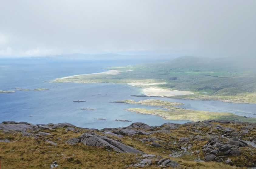
Picture: Astounding panoramas when the mist clears.
This is usually done in conjunction with Benchoona itself. One approach is to start at the Lettergesh beach car park at LtrGesh (L737 631) D and follow the uphill road and track up towards Benchoona, which eventually peters out. The terrain is then quite steep, initially grassy and increasingly rocky as one ascends. Upon reaching the rocky summit of Benchoona, the East top is a mere 500m east around the small Benchoona Lough, with just 20m or so ascent.
Use of MountainViews is governed by conditions and a privacy policy.
Read general information about the site. Opinions in material here are not necessarily endorsed by MountainViews.
Hillwalking is a risk sport. Information in comments, walks, shared GPS tracks or about starting places may
not be accurate for example as regards safety or access permission. You are responsible for your safety and your permission to walk.
See the credits and list definitions.


 Our Facebook page.