Members and Supporters, the MountainViews Committee requests your help to meet the costs of the website and of other activities such as insured events or publications.
Feature count in area: 34, all in Galway,
OSI/LPS Maps: 37, 44, EW-CON, MSW
Highest Place: Benbaun 729m
Starting Places (48) in area Twelve Bens: Angler's Return, Barr na nÓran Road, Ben Lettery Hostel, Bogville Road, Bridge St Clifden, Bundorragha Estuary Cross, Bunnageeha, Cannaclossaun, Connemara Mountain Hostel, Connemara National Park Visitor Centre, Dernasliggaun, Doire na bhFlann North, Doughruagh CP, Emlaghdauroe Bridge, Emlaghdauroe South, Fee Lough SW, Foher, Glasbeg Stream, Glashmore Bridge, Glencoaghan River Bridge, Glencraff Road End, Gleninagh River, Illaunroe North, Illaunroe South, Inaghbeg Path, Kylemore Abbey Exit, Kylemore River, Letterfrack Lodge, Lettergesh Beach, Lough Anivan Bend, Lough Auna S, Lough Fee East, Lough Nacarrigeen S, Lough Tanny, Muck Lough NW, Nambrackkeagh Lough, Owen na Baunoge River, Owengar Bridge, Owenglin River, Owenwee River, Pollacappul Lough E, Pollacappul Lough W, Shanvally, Skeaghatimull, Ten Bens Cottage, Tooreennacoona River, Western Way Cnoc na hUilleann, Western Way Inagh Cottages
Summits & other features in area Twelve Bens: Cen: Lough Auna Hills: Cregg 297m, Townaloughra East Top 216m Cen: Polladirk: Bencullagh 632m, Maumonght SW Top 454m, Diamond Hill 442m, Knockbrack 442m, Maumonght 602m E: Glencorbet: Benbaun 729m, Benbrack 582m, Benbaun 477m, Knockpasheemore 412m, Benfree 638m, Muckanaght 654m N: Doughruagh: Altnagaighera 549m, Benchoona 581m, Benchoona East Top 585m, Currywongaun 273m, Doughruagh 526m, Doughruagh South Top 525m, Garraun 598m, Garraun South Top 556m, Letterettrin 333m SE: Glencoaghan Loop: Bencollaghduff 696m, Benglenisky 516m, Benlettery 577m, Bencorr 711m, Bencorr North Top 690m, Bencorrbeg 577m, Binn an tSaighdiúra 653m, Benbreen 691m, Benbreen Central Top 680m, Benbreen North Top 674m, Derryclare 677m, Bengower 664m
Note: this list of places may include island features such as summits, but not
islands as such.
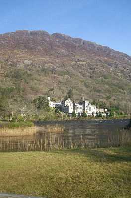
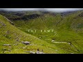
Doughruagh, 526mMountain Dúchruach A name in Irish,
Place Rating ..
(Ir. Dúchruach [TR], 'black stack'), Dú Chruach, Galway County in Connacht province, in Arderin Lists, Doughruagh is the 487th highest place in Ireland.
Grid Reference L75059 59430,
OS 1:50k mapsheet 37 Place visited by: 115members, recently by: srr45, Carolineswalsh, Kaszmirek78, Superterence, paulbrown, Ulsterpooka, Sweeney, trevorf, annem, mountainmike, derekfanning, Jimmy600leavey, Frankierooney, Camp, upper
I visited this place: NO (You need to be a logged-in member for this.)
Longitude: -9.886692, Latitude: 53.570049, Easting: 75059, Northing: 259430,
Prominence: 211m, Isolation: 0.1km ITM: 475036 759450 Bedrock type: Hornblende metagabbros & metanorites, (Metagabbro and Related Lithologies) Notes on name: Half-way up Doughruagh on very steep ground is a statue of the Sacred Heart, erected in 1932 by the Benedictine nuns of Kylemore Abbey in thanks for their safe delivery to Kylemore. They had been forced to abandon their convent near Ypres in Belgium during hostilities in World War I. Walks: for a route on the S face of Doughruagh , see Kevin Corcoran, West of Ireland Walks, 93-101 or Paddy Dillon, Connemara, 38-44.
Short or GPS IDs, 6 char: Dghrgh, 10 char: Doughruagh Linkback: https://mountainviews.ie/summit/400/
Gallery for Doughruagh (Dúchruach) and surrounds
Summary
for Doughruagh (Dúchruach):
Rocky summit with access issues from Kylemore Abbey
Summary created by liz50
2017-03-22 17:41:29
Located behind Kylemore Abbey, it has been reported that access from the grounds is no longer allowed. It is possible to park in a small lay-by at A (L77637 58711) and walk approx 30m along the road to a 'gate' with access to a grassy field and the saddle below Doughruagh. A steep rocky ascent to the summit. An alternative start point to the West at Anivan Bd (L72134 59157) with roadside parking. Ascend ridge to Currywongaun and small drop across wet bog before a steep rocky ascent to the summit. The top is rocky and dotted with lakes and pools and fine views over Connemara
Located just behind the famous and picturesque Kylemore Abbey, the upper reaches of this mountain look somewhat daunting for ramblers or hillwalkers without a love for scrambling. This is an alternative approach. After paying your 3.50 Euro!! to get into the grounds you follow the path to the large statue 1/2 way up the mountain. Once at the statue head to the right following traces of a path, which stays roughly at the same height until you completely round the east side of the mountain and reach the saddle between it and Garraun. The slope on this side makes the access to the summit and its lakes very easy. An alternative or extension to this walk is to contour around from the saddle to the lake on the north side of Doughruagh. After passing around the lake continue to follow the contours at around 280 - 300m until you arrive back at the statue again. Linkback: mountainviews.ie/summit/400/comment/367/
Read Less
Read More
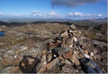
Picture: Doughruagh Cairn
Colin Murphy on Doughruagh
by Colin Murphy
8 Jun 2008
Parked on the NE of Kylemore Lough (just where the road around the lake turns sharply south east) where you'll find space enough for about 3/4 cars. About 30 metres back along the road you'll find a wooden pallet doubling as a gate which allows access into a grassy field. From here you've a 1.5k walk to the NW up a gently rising slope until you reach the saddle between Doughruagh and Garraun South Top. From here the gradient steepens sharply, becoming much rockier as you ascend. The top is a broad rocky expanse speckled with pools which could easily double as an alien planet in a sci-fi movie! A cairn marks the highest point at the western end and on the day I stood there the views of the Bens, Maamturks, Atlantic coastline etc etc were indescribably beautiful. Round trip took me 3 hours, though I could easily have lingered over the view for another 12 hours! Linkback: mountainviews.ie/summit/400/comment/3158/
Read Less
Read More
Parking problem
by Jamessheerin
8 Nov 2016
Please be advised that parking at Kylemore Abbey is now off limits. I was there last Sunday (Nov 6, 2016) with my club and we were informed that we "could not leave the grounds", we "couldn't park there and climb the nearby hills" and "we should park in Leenaun", 10 miles away! I believe the Abbey grounds are under new management and this is their way of a friendly reception. We, the club, have been parking there for over twenty years (taking up a very small part of a very large carpark)... and spending a sizable amount of money in the cafe afterwards. We have never abused the free parking there in any way. After we left last Sunday there were only three cars left in the carpark. And thirty less people to spend money in the coffee shop! Linkback: mountainviews.ie/summit/400/comment/18703/
Read Less
Read More
simon3 on Doughruagh
by simon3
26 Dec 2003
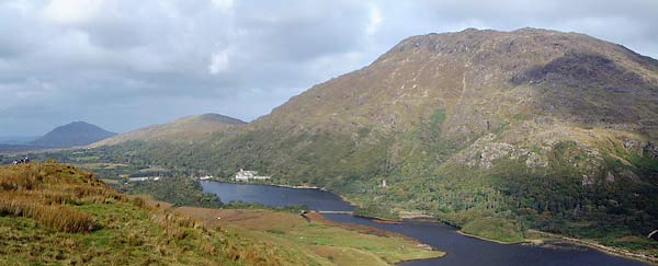
This photo taken on a misty day in May shows Doughruagh from the NE. Traversing the top of Doughruagh is an exercise in winding around rocky knolls of sparsely vegetated rock mixed with ponds. Although a short distance, walking from east to west in mist to find the top (which has a collection of rusty metalwork) is a navigation challenge. The lake below the summit is Knappagh Lough. The three smaller lakes just over the right flank of Doughruagh are in the area of Currywongan, with a highest point of 273m. Linkback: mountainviews.ie/summit/400/comment/777/
Read Less
Read More
simon3 on Doughruagh
by simon3
26 Dec 2003
One way up Doughruagh is described by Tony Whilde [Irish Walk Guides: West, Ed J Lynam 1978]. Start north of Kylemore Lough at around B (L766 587). Drivers can park on the road here. The start area is particularly well shown on the Harvey Connemara map. Head NE from the start to gain height and open ground. I found you have to deal with rhodendron, a small stream and some cliffs – nothing too difficult. Once onto the open ground you can make for the pass between Doughruagh and Lemnaheltia where there is a green road and then turn left for Doughruagh.
Tim Robinson [Book of the Irish Countryside, Ed Frank Mitchell 1987] adds to the many paeans to Romanticism that you find in descriptions of the area as follows “..Dúchruach, the ‘black stack’, that lowers over the wooded valley and the lake of Kylemore, in perfect sympathy with the nineteenth-century Gothic fantasy of Kylemore Abbey.”
In contrast, for interesting background, Kevin Corcoran [West of Ireland Walks 1993] describes the lower, SW slopes of Doughruagh. Amongst many other delights of the flora and fauna he mentions that at around the point you emerge on the open ground described above “Around these cliffs you may be lucky enough to hear the haunting scream of Peregrine Falcon (Falco peregrinus) ..”
The autumn photo taken from Benbaun, shows the Abbey just right of centre. The route described starts in the bottom right corner. The main bumpy ridge of the mountain is well shown. The dark triangular mountain to the left is Tully Mountain (356m). Linkback: mountainviews.ie/summit/400/comment/776/
Use of MountainViews is governed by conditions and a privacy policy.
Read general information about the site. Opinions in material here are not necessarily endorsed by MountainViews.
Hillwalking is a risk sport. Information in comments, walks, shared GPS tracks or about starting places may
not be accurate for example as regards safety or access permission. You are responsible for your safety and your permission to walk.
See the credits and list definitions.


 Our Facebook page.