Members and Supporters, the MountainViews Committee requests your help to meet the costs of the website and of other activities such as insured events or publications.
Feature count in area: 34, all in Galway,
OSI/LPS Maps: 37, 44, EW-CON, MSW
Highest Place: Benbaun 729m
Starting Places (48) in area Twelve Bens: Angler's Return, Barr na nÓran Road, Ben Lettery Hostel, Bogville Road, Bridge St Clifden, Bundorragha Estuary Cross, Bunnageeha, Cannaclossaun, Connemara Mountain Hostel, Connemara National Park Visitor Centre, Dernasliggaun, Doire na bhFlann North, Doughruagh CP, Emlaghdauroe Bridge, Emlaghdauroe South, Fee Lough SW, Foher, Glasbeg Stream, Glashmore Bridge, Glencoaghan River Bridge, Glencraff Road End, Gleninagh River, Illaunroe North, Illaunroe South, Inaghbeg Path, Kylemore Abbey Exit, Kylemore River, Letterfrack Lodge, Lettergesh Beach, Lough Anivan Bend, Lough Auna S, Lough Fee East, Lough Nacarrigeen S, Lough Tanny, Muck Lough NW, Nambrackkeagh Lough, Owen na Baunoge River, Owengar Bridge, Owenglin River, Owenwee River, Pollacappul Lough E, Pollacappul Lough W, Shanvally, Skeaghatimull, Ten Bens Cottage, Tooreennacoona River, Western Way Cnoc na hUilleann, Western Way Inagh Cottages
Summits & other features in area Twelve Bens: Cen: Lough Auna Hills: Cregg 297m, Townaloughra East Top 216m Cen: Polladirk: Bencullagh 632m, Maumonght SW Top 454m, Diamond Hill 442m, Knockbrack 442m, Maumonght 602m E: Glencorbet: Benbaun 729m, Benbrack 582m, Benbaun 477m, Knockpasheemore 412m, Benfree 638m, Muckanaght 654m N: Doughruagh: Altnagaighera 549m, Benchoona 581m, Benchoona East Top 585m, Currywongaun 273m, Doughruagh 526m, Doughruagh South Top 525m, Garraun 598m, Garraun South Top 556m, Letterettrin 333m SE: Glencoaghan Loop: Bencollaghduff 696m, Benglenisky 516m, Benlettery 577m, Bencorr 711m, Bencorr North Top 690m, Bencorrbeg 577m, Binn an tSaighdiúra 653m, Benbreen 691m, Benbreen Central Top 680m, Benbreen North Top 674m, Derryclare 677m, Bengower 664m
Note: this list of places may include island features such as summits, but not
islands as such.
Bencollaghduff, 696mMountain An Bhinn Dubh A name in Irish,
Place Rating ..
Ir. An Bhinn Dubh [TR#], 'black peak'), Binn Dubh, Galway County in Connacht province, in Arderin, Vandeleur-Lynam, Irish Best Hundred, Irish Highest Hundred Lists, An Bhinn Dubh is the third highest mountain in the Twelve Bens area and the 119th highest in Ireland.
Grid Reference L79782 52992,
OS 1:50k mapsheet 37 Place visited by: 384members, recently by: NualaB, nupat, rhw, DeirdreM, orlaithfitz, maoris, Prem, Carolineswalsh, ConMack23, abptraining, SmirkyQuill, Kirsty, Carolyn105, Kaszmirek78, miriam
I visited this place: NO (You need to be a logged-in member for this.)
Longitude: -9.812862, Latitude: 53.51334, Easting: 79782, Northing: 252992,
Prominence: 191m, Isolation: 1.3km ITM: 479765 753013 Bedrock type: Pale quartzites, grits, graphitic top, (Bennabeola Quartzite Formation) Notes on name: Bencollaghduff means ‘peak of the black hags’. The black hags in question are cormorants [TR]. The OSI form Binn Dhubh represents a prescribed standard modern Irish form. Tim Robinson's Binn Dubh represents the local dialect, which omits lenition of d and t when the previous word ends in a dental consonant.
Short or GPS IDs, 6 char: Bnclgh, 10 char: Bnclghdf Linkback: https://mountainviews.ie/summit/115/
Gallery for Bencollaghduff (An Bhinn Dubh) and surrounds
Summary
for Bencollaghduff (An Bhinn Dubh):
Rocky peak with great views in the central Bens
Summary created by markmjcampion, Colin Murphy
2021-02-06 10:53:15
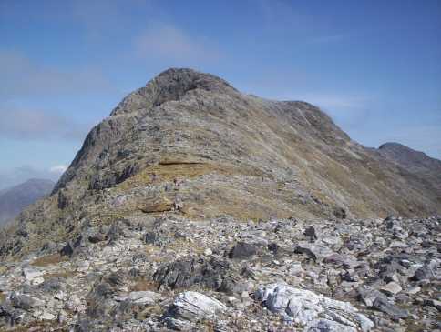
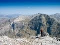
Picture: The ascent of Binn Dubh from Mam Eidhneach
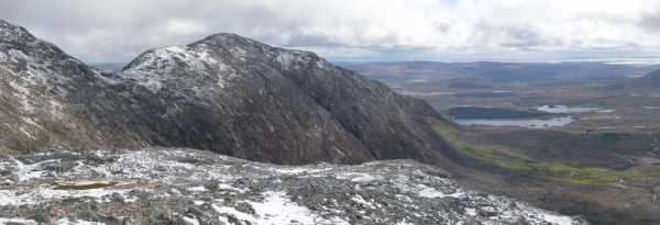
Bencollaghduff is in the middle both of the 12 Bens and the Glencoaghan Horseshoe. It has a long E/W summit area, very rocky with steep-sided summit with the steepest ground on its northern approaches. There are magnficent views of a lot of the other Bens, Maamturks and the Benchoona massif while further afield the south Mayo hills are up for relatively close scrutiny.
S. From the south Bencollaghduff is normally done as part of the Glencoaghan horseshoe - clockwise startng at Ben Lettery YH BenLet Hst (L77696 48225) or anticlockwise from approx. TenBen Ctg (L80532 48861). Either route makes for a very strenuous day out with a lot of up and down on steep, rocky ground - usually well in excess of 7 hours for the circuit. See Ben Lettery and/or Derryclare for starting details. Brncollaghduff is one of the easier parts of the route not having too much steep ground on either approach.
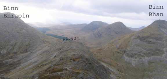
NE. Park on the Inagh Valley Road at appro. A (L81981 56186) and follow the Glen Eidhneach road SW until you reach a distinct moraine. This in turn leads to a sheep track on east side of Benbaun. Follow the track up to the 3-way mountain pass known as Mam Eidhneach. From the gap between (B Dubh and B Bhraoin) head East along a rocky shoulder to Binn Dubh's summit. 3.5 to 4hrs round trip.
From the same starting point you can also head up via the Bencorrbeg ridge - a rocky approach with great views over Lough Inagh.
Notable tracks include track/3581 and track/3205. The Glencoaghan circuit is approximated by track/2731.
Left car at [B (L820 562)] and walked up thru Gleann Eidhneach until I reached a distinct moraine. This in turn leads you to a sheep track on east side of Bin Bhan. I followed the track up to the 3-way mountain pass, Mam Eidhneach. From the gap between (B Dubh and B Bhraoin) I headed East along Binn Dubhs rocky shoulder, scrambling past a cairn at 563m [C (L791 529)] to a 2nd cairn at summit. I took the photo of the 3-way pass about 5 min from summit on way down. If you see mist coming whilst on way up/down, be sure that you take bearing(s). Trip Time 3h 25min incl. 15min stops. Linkback: mountainviews.ie/summit/115/comment/2198/
Read Less
Read More
weedavie on Bencollaghduff
by weedavie
26 Apr 2004
Don’t believe the Connemara hillwalk booklet that says the Glen Chochan circuit is 6 to 7 hours. I think it's a meaningless application of Naismith’s rule. It took us 8.5 without the access walk and we weren’t hanging round much.
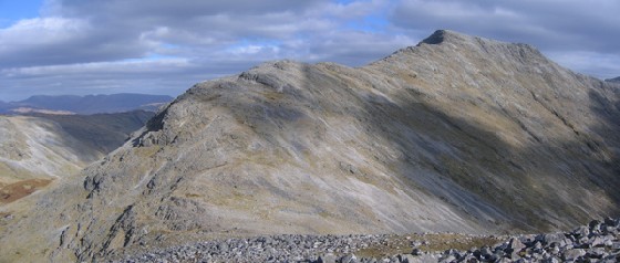
The eastern half of the circuit is straightforward, even in a heavy April snowfall. We went up the south butt of the ridge then followed the slope up to Derryclare. We carried on just west of north without much descent and ascent to Binn Corr. Between its tops was an excellent place for the snow to stop and the cloud to roll back. From the North West top we’d a tremendous view of the rocky slopes of Binn Dubh to the west. We were now approaching the trickiest moment in this half of the round, the pronunciation of Mam na bhFonsai. Nothing in our experience of Scots Gaelic prepared us for this.
The ascent of Binn Dubh is easy on good rock, up to the shattered approach to the summit.
After Binn Dubh we found the trickier western leg of the Chochan circuit. The climb south to Binn Bhraoin was straightforward although the grain of the rock tended to encourage us to the left. This might want watching in mist. Similarly the ridge wanders west, south then south east between some ill-defined tops so a bit of attention would be in order.
The next descent’s the easiest of the day if you don’t feel too guilty about repaying Galway’s hospitality by slipping a few cubic metres of scree down the slopes. On the other hand the ascent to Binn Gabhar’s positively tricky. A developing path took us up among crags over the first half of the slope. It disappeared but trending to the right worked all right after that, scrambling up some fairly obvious ledges and gullies. The summit has too many cairns but we visited them all to make sure.
Binn Lettery’s next and must seem no distance going north in the morning. Seemed a long way at the end of the round. It’s a fantastic viewpoint. I don’t know the best descent to the Youth Hostel but a straight line cost us 15 minutes getting round crags on the upper slopes.
This is an amazing circuit. Getting something of this sort to ourselves on an April Sunday in Scotland would be unthinkable. But we saw no people and no marks in the snow. A ripple of applause is due to the fearless fliers of Aer Arran whose direct Edinburgh Galway flight makes this a workable weekend trip.
Mam Eidhneach is about half way on the Chochan circuit and from here it is a 40min haul/scramble to the top of Binn Dubh. From the top I followed a bearing of 130 degrees to meet a cairn before dropping down to Mam na BhFonsai. Linkback: mountainviews.ie/summit/115/comment/2208/
Read Less
Read More
Picture: The ascent of Binn Dubh from Mam Eidhneach (Maumina) or Maumnageergh col.
eflanaga on Bencollaghduff
by eflanaga
3 May 2006
After descending to Maumina (Maumnageeragh) Col D (L78882 52805) from the eastern slope of Binn Bhraoín, (having delayed on its Northern Top to take some pictures) I managed to catch up with the other eight members of the Mid-Ulster Walking Club who were in the process of completing a west to east crossing of the Glencoaghan Horseshoe walk. The group had been about to start their ascent of Bin Dubh the next peak in the circuit, when they stopped to chat with another group of walkers who were doing the walk from the opposite direction. Both groups met just above Maumnageeragh Col to swap pleasantries. It transpired that the other group was also from the North (Belfast Civil Service Walking Club). The two gentlemen from Galway we had met earlier on Ben Gabhar (first part of walk) and later on Binn Bhraoin summit were also there and they accompanied our party to the summit of Binn Dubh (Bencollaghduff). Buoyed by the camaraderie engendered by our meeting and the unplanned rest break, we bade our fellow walkers fair wind and began our ascent of Binn Dubh. Surprisingly, this was not as difficult as it first appeared although after turning south past the second spot height the final climb to the summit cairn required a little more care and the use of hands in one or two places. The broad rocky summit provided fantastic views to the west such as those described in reports of the previous stages but also provided the first relatively unimpeded views across the northern edge of Lough Inagh over to the northern Mamturks. The views north over Binn Bhán’s eastern spur & Knockpasheemore towards Kylemore Lough & Killary Harbour were awesome in the late afternoon sunlight. To the south the final legs of the Horseshoe, Binn Chorr & Binn Doire Chláir awaited. Linkback: mountainviews.ie/summit/115/comment/2328/
Use of MountainViews is governed by conditions and a privacy policy.
Read general information about the site. Opinions in material here are not necessarily endorsed by MountainViews.
Hillwalking is a risk sport. Information in comments, walks, shared GPS tracks or about starting places may
not be accurate for example as regards safety or access permission. You are responsible for your safety and your permission to walk.
See the credits and list definitions.


 Our Facebook page.