Members and Supporters, the MountainViews Committee requests your help to meet the costs of the website and of other activities such as insured events or publications.
Feature count in area: 34, all in Galway,
OSI/LPS Maps: 37, 44, EW-CON, MSW
Highest Place: Benbaun 729m
Starting Places (48) in area Twelve Bens: Angler's Return, Barr na nÓran Road, Ben Lettery Hostel, Bogville Road, Bridge St Clifden, Bundorragha Estuary Cross, Bunnageeha, Cannaclossaun, Connemara Mountain Hostel, Connemara National Park Visitor Centre, Dernasliggaun, Doire na bhFlann North, Doughruagh CP, Emlaghdauroe Bridge, Emlaghdauroe South, Fee Lough SW, Foher, Glasbeg Stream, Glashmore Bridge, Glencoaghan River Bridge, Glencraff Road End, Gleninagh River, Illaunroe North, Illaunroe South, Inaghbeg Path, Kylemore Abbey Exit, Kylemore River, Letterfrack Lodge, Lettergesh Beach, Lough Anivan Bend, Lough Auna S, Lough Fee East, Lough Nacarrigeen S, Lough Tanny, Muck Lough NW, Nambrackkeagh Lough, Owen na Baunoge River, Owengar Bridge, Owenglin River, Owenwee River, Pollacappul Lough E, Pollacappul Lough W, Shanvally, Skeaghatimull, Ten Bens Cottage, Tooreennacoona River, Western Way Cnoc na hUilleann, Western Way Inagh Cottages
Summits & other features in area Twelve Bens: Cen: Lough Auna Hills: Cregg 297m, Townaloughra East Top 216m Cen: Polladirk: Bencullagh 632m, Maumonght SW Top 454m, Diamond Hill 442m, Knockbrack 442m, Maumonght 602m E: Glencorbet: Benbaun 729m, Benbrack 582m, Benbaun 477m, Knockpasheemore 412m, Benfree 638m, Muckanaght 654m N: Doughruagh: Altnagaighera 549m, Benchoona 581m, Benchoona East Top 585m, Currywongaun 273m, Doughruagh 526m, Doughruagh South Top 525m, Garraun 598m, Garraun South Top 556m, Letterettrin 333m SE: Glencoaghan Loop: Bencollaghduff 696m, Benglenisky 516m, Benlettery 577m, Bencorr 711m, Bencorr North Top 690m, Bencorrbeg 577m, Binn an tSaighdiúra 653m, Benbreen 691m, Benbreen Central Top 680m, Benbreen North Top 674m, Derryclare 677m, Bengower 664m
Note: this list of places may include island features such as summits, but not
islands as such.
Currywongaun, 273mHill Corr Uí Mhongáin A name in Irish,
Place Rating ..
'Corr' - round hill, pointed hill, hollow; pointed, conspicuous, odd. Corr Uí Mhongáin could mean 'Uí Mhongáin's' 'round' or 'pointed' 'hill'. According to ainm.ie surnames related to Mongáin include: Ó Maingín, Ó Mainín, Ó Mainnín, Ó Maithnín, Mangan, Manning, Mannion, Mongan, Corrywongaun Hill, Galway County in Connacht province, in Binnion Lists, Currywongaun is the 1229th highest place in Ireland.
Grid Reference L73100 59600,
OS 1:50k mapsheet 37 Place visited by: 19members, recently by: Wilderness, padstowe, Fergalh, GSheehy, eamonoc, Lauranna, markmjcampion, patmoran, liz50, Jamessheerin, juliewoods, bryanmccabe, tphase, deirdrenig, mdoc1969
I visited this place: NO (You need to be a logged-in member for this.)
Longitude: -9.916313, Latitude: 53.571106, Easting: 73100, Northing: 259600,
Prominence: 109m, Isolation: 2km ITM: 473077 759620 Bedrock type: Hornblende metagabbros & metanorites, (Metagabbro and Related Lithologies) Notes on name: http://www.logainm.ie/ga/18325
Short or GPS IDs, 6 char: Crywng, 10 char: Crywngn Linkback: https://mountainviews.ie/summit/1182/
Gallery for Currywongaun (Corr Uí Mhongáin) and surrounds
Summary
for Currywongaun (Corr Uí Mhongáin):
Rough and Rocky
Summary created by liz50
2017-03-22 17:54:15
Park off road in a small lay-by at Anivan Bd (L72134 59157) and ascend the spur in a roughly Easterly direction to the summit. Usually climbed en-route to its larger neighbor Doughraugh.
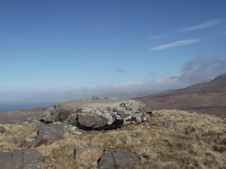
A very rough and rocky hill with a small stone and cement platform at its top (see photo), and 2-3 bigger structures dotted around immediately near the summit. There are a few more dotted around the subisdiary summit around 600m to the west. These are the remains of the Marconi receiving station opened here in 1913 to complement the better-known station at Derrygimlagh near Clifden.
Though not very high, gives a great sense of isolation. The view to the east is the empty plain of Pollacappul stretching out to Doughruagh, Benchoona and Garraun. As this plain is raised about 100m above the surrounding townlands, there are no habitations and few traces of human impact. Doughruagh can be reached from here. Also views of nearby Diamond Hill; Ben Brack to south-east with other Bens behind; Letter Hill (aka Tully Mountain) to the west; and the Atlantic (including Inishturk, Clare Island and others) to the west and north.
There's a layby with space for a couple of cars around Anivan Bd (L722 592), but I left the road at around A (L718 596). Quite a cliffy climb with extremely complicated terrain. The cliffs are easily gone round on the way up, but coming back down I found myself several times standing over awkward rocky descents I hadn't seen coming. Obviously easier to start closer to the layby. Linkback: mountainviews.ie/summit/1182/comment/15920/
Read Less
Read More
Hill at forefront of technology
by chalky
29 Oct 2014
Had a conversation with the farmer on the way down who told me that the concrete platforms referred to are the remains of a Marconi installation that produced the first telegraph signals to America in 1908. Linkback: mountainviews.ie/summit/1182/comment/17737/
Read Less
Read More
Looking east
by markwallace
27 Dec 2017
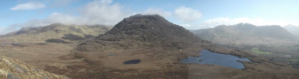
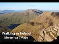
Looking east from Currywongaun. Doughruagh and Lough Touther in the centre of the photo.. Benchoona and Garruan to the left of the photo; Ben Brack to the right. Easiest way to cross to Doughruagh is by staying slightly left of Lough Touther, Linkback: mountainviews.ie/summit/1182/comment/15921/
Use of MountainViews is governed by conditions and a privacy policy.
Read general information about the site. Opinions in material here are not necessarily endorsed by MountainViews.
Hillwalking is a risk sport. Information in comments, walks, shared GPS tracks or about starting places may
not be accurate for example as regards safety or access permission. You are responsible for your safety and your permission to walk.
See the credits and list definitions.


 Our Facebook page.