This website uses cookies, which are small text files that the website puts on your device to facilitate operation. Cookies help us provide a better service to you. They are used to track general user traffic information and to help the website function properly.
Feature count in area: 12, all in Donegal,
OSI/LPS Maps: 11, 12, 6, 7
Highest Place: Culliagh SE Top 369m
Starting Places (9) in area Donegal East: Ardnabreena, Ballystrang School Ruin, Corlacky Burn, Edenacarnan East, Edenacarnan South, Garrangalta Rocks, Knockbrin, Labbadoo Wood, Sruthaunagallagh Stream
Summits & other features in area Donegal East: N: Raphoe: Binnion Hill 190m, Dooish Mountain 266m, High Bank 171m, Mongorry Hill 284m NW: Letterkenny Hills: Ballystrang 292m, Cark Mountain 364m, Culliagh SE Top 369m, Gregory Hill 336m, Knockbrin 259m S: Castlefinn Hills: Croaghan Hill 217m, Fearns Hill 231m, Meenavally 219m
Note: this list of places may include island features such as summits, but not
islands as such.
Culliagh SE Top, 369mHill An Coileach (mullach thoir theas) A name in Irish,
Place Rating ..
(Ir. An Coileach [OSI], 'the cock'), Donegal County in Ulster province, in Binnion Lists, Culliagh SE Top is the highest hill in the Donegal East area and the 1023th highest in Ireland. Culliagh SE Top is the most westerly summit in the Donegal East area.
Grid Reference C08165 02048,
OS 1:50k mapsheet 6,11 Place visited by: 18members, recently by: conormcbandon, Carolyn105, dregish, Claybird007, dino, wintersmick, eamonoc, AntrimRambler, Aidy, sandman, Lucky1, chalky, Fergalh, mark-rdc, Peter Walker
I visited this place: NO (You need to be a logged-in member for this.)
Longitude: -7.873624, Latitude: 54.866084, Easting: 208165, Northing: 402048,
Prominence: 194m, Isolation: 2.3km ITM: 608112 902036 Bedrock type: Banded semi-pelitic & psammitic schist, (Termon Formation) Notes on name: Situated in Culliagh townland. An Coileach, 'the cock', and An Chearc, 'the hen', are neighbouring mountains.
Short or GPS IDs, 6 char: ClghSE, 10 char: ClghSETp Linkback: https://mountainviews.ie/summit/879/
Gallery for Culliagh SE Top (An Coileach (mullach thoir theas)) and surrounds
Summary
for Culliagh SE Top (An Coileach (mullach thoir theas)):
A very worthwile ascent!
Summary created by Harry Goodman, Garmin
2012-11-05 17:11:28
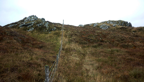
Picture: The twin rocky tops on the summit.
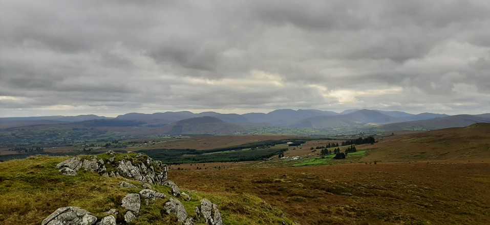
When considering what to and what to climb in an area as lavishly bedecked with fine mountains and scenery as Donegal it is easy to understand how this hill could come to languish in the "To do" list for many. But what it has on offer, in terms of the vista from the top, and the "agreeableness" of the walking conditions underfoot.make this small hill a fine vantage point for admiring the mountains of NW Donegal. In particular the unusual perspective of Errigal to the north, presenting as an almost perfect equilateral triangle and the fine view SW to the Bluestacks make the modest effort to climb Culliagh SE Top well worth while!
There is space for several cars in a large pull-in area on the right (S) at A (C074 012) . Walk NE along the road for approximately 600m to a where a gate crosses it. Once past the gate strike out NNE for the summit. Complete trip can easily be walked in less than an hour.
(See track 2094).
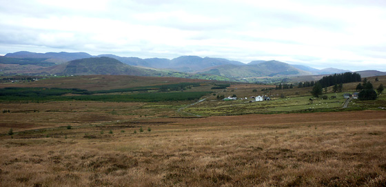
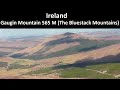
Picture: Bluestacks from SW shoulder of Culliagh SE Top
Last but by no means least in my list of Donegal NW tops.
by Harry Goodman
6 Oct 2015
I climbed this hill on 25 Oct 2012 as my final top in the MV list for Donegal NW. I parked at a large pull in area on the right (S) side of the minor road B (C07443 01200) and then went NE along the road for 600m to where a gate crossed it. Once past the gate I initially followed the line of a fence left (N) up the rough grassy slope but soon abandoned it and headed NE directly for the top. Although from the map the high point seems to lie on or immediately S of a fence crossing the summit area I found that the fence actually crosses along a small trough with two rocky upcrops on either side of it vying to be the high point of the hill. The difference in height appears minimal but in my view the higher point lies on the upcrop to the N side of the fence. However given the very close proximity of the two tops to each other it is very easy to visit both. As Garmin has already commented in the short summary this small hill is a marvellous vantage point for a sweep around the main hills of NW Donegal and even further afield to the Sperrins and Dartry Mts. However the view SW is perhaps the best uninterupted view of the Bluestacks I have experienced in Donegal extending from Barnesmore Gap NW across the main ridge, past Gaugin Mt to Agla Mt. and the small rocky profile of Scraigs. Nearer at hand directly in front of the ridge was the distinctive small hill of Altnapaste. Indeed this panorama is the only uninterupted view from Culliagh SE Top. What I did not anticipate or expect was the extent of wind turbine coverage in this small compact group of tops. They total in excess of 60 and there are signs of more to come. As a consequence any views other than SW are restricted by this large wind farm. As a walk up and down can be done in an hour I decided not to return by way of ascent but rather extend my walk by following the fence line down NW over relatively easy ground and then SW over a patch of boggy peat hags to Pt. 358 (Three Tops ) C (C07003 01730) and a couple of nearby lower but distinctive satellite tops which I assume give the higher top it's name. I then dropped down SE past a small copse of trees on the righjt to join the road D (C07365 01140) where I turned left and back to the car a mere 100m along. A most enjoyable ramble of some 4.5k over gentle slopes comprising a mix of grass, some boggy areas and a few unexpected rocky tops. Linkback: mountainviews.ie/summit/879/comment/14847/
Read Less
Read More
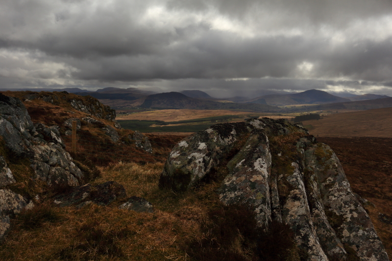
Picture: Stormy skies over the Bluestacks from summit.
Excellent Views Of The Bluestacks
by Aidy
25 Apr 2016
This was my third small hill of the day after nearby Ballystrang and Cark Mountain, and this was undoubtedly the pick of the bunch. All three are short walks, but this one was marginally more difficult as the walking was on heathery open hillside, rather than stretches of wind farm access road, but the walk is so short it was no hardship. The reward was really excellent views into the Bluestacks. This would have been a worthy hill even if it wasn't in my local 100. Linkback: mountainviews.ie/summit/879/comment/18510/
Read Less
Read More
Short but Rewarding.
by dino
20 Oct 2021
Really enjoyed this walk and followed Track 2094 by Garmin. Plenty of parking at the start, easy navigation along a farm track and then grazed grass and heather with good ground underfoot. There is no summit marker and a number of possible candidates. My favourite candidate was the rocky outcrop across the fence but the views made it more than worth crossing the fence twice. Great views towards the Bluestack Mountains and Errigal and Muckish were also visible today. The return is on a slightly different route than the ascent and makes a nice little loop walk. Great rewards for very little effort.
Blog post and photos for the trip: https://idlecyclist.wordpress.com/2021/10/20/hike-cuilagh-se-top-and-cark-mountain/
. Linkback: mountainviews.ie/summit/879/comment/23311/
Use of MountainViews is governed by conditions and a privacy policy.
Read general information about the site. Opinions in material here are not necessarily endorsed by MountainViews.
Hillwalking is a risk sport. Information in comments, walks, shared GPS tracks or about starting places may
not be accurate for example as regards safety or access permission. You are responsible for your safety and your permission to walk.
See the credits and list definitions.


 Our Facebook page.