Cookies. This website uses cookies, which are small text files that the website puts on your device to facilitate operation. Cookies help us provide a better service to you. They are used to track general user traffic information and to help the website function properly.

Click to hide this notice for 30 days.
Welcome to MountainViews
If you want to use the website often please enrol (quick and free) at top right.
Overview
Detail
Zoom: ??
For more map options click on any overview map area or any detail map feature.
Detail Map Features
Showing 1 items:
Slievekirk 370m,
Find Suggested Walks
Find hill, mountain, island, coastal feature.
Videos


Recent Contributions
Get Notifications

Letterettrin - a perspective on the N Connemara peaks

Carrigroe: Twin tops

Kilbrony Park Ramble

Grieve Hill: Summit position recently revised.

Knocknakilton & Cummeen, Dingle Penninsula

Leean Mountain: Ireland's Best Small Hill?

Scarr North-West Top: Popular spot in the heart of the mountains

Croaghnageer and Croghanirwore

Silvermines Hydro Project

Blackstairs Mountain: Good access and a great viewpoint above a patchwork quilt

Brown Mountain: Granite - mica schist boundary

9 km walk around Mullaghmeen Woods April 2025

Conditions and Info
Use of MountainViews is governed by conditions and a privacy policy.
Read general information about the site.
Opinions in material here are not necessarily endorsed by MountainViews.
Hillwalking is a risk sport. Information in comments, walks, shared GPS tracks or about starting places may not be accurate for example as regards safety or access permission. You are responsible for your safety and your permission to walk.
See the credits and list definitions.
Video display
Sperrin Mountains Area   NW: Maheramason Hills Subarea
Place count in area: 64, OSI/LPS Maps: 12, 13, 6, 7, 8 
Highest place:
Sawel, 678m
Maximum height for area: 678 metres,     Maximum prominence for area: 657 metres,

Places in area Sperrin Mountains:
E: Magherafelt Hills:   Slieve Gallion NE Top 493.6m
E: Magherafelt Hills:   Slieve Gallion 526.6m
N: Claudy Hills:   Crockdooish 321mCurradrolan Hill 270mEglish 277mLetterlogher 249mMullaghmeash Hill 244mSlieveboy 259mStraid Hill 303m
NE Cen: Glenelly North East:   Barnes Top 456mCraigagh Hill 460mCrockbrack 526.1mKnockanbane Mountain 441mMeenard Mountain 620mMeenard Mtn W Top 480mMullaghaneany 627mMullaghash 480mMullaghsallagh 485mOughtmore 569mSpelhoagh 568m
NE: Glenshane North:   Benbradagh 465mBoviel Top 454mCarn Hill 448mCarntogher 464mMoneyoran Hill 414m
NE: Glenshane South:   Bohilbreaga 478mCoolnasillagh Mountain 423mCorick Mountain 430mCrockalougha 407mMullaghmore 550mWhite Mountain 537m
NW Cen: Glenelly North West:   Dart Mountain 619mDart Mountain North-West Top 525mLearmount Mountain 489mLearmount Mountain South Top 492mMullaghasturrakeen 581mMullaghcarbatagh 517mMullaghclogha 635mMullaghclogher 572mMullaghdoo 568mSawel 678m
NW: Maheramason Hills:   Clondermot Hill 220mGortmonly Hill 218mSlievekirk 370m
SE Cen: Glenelly South East:   Carnanelly 562mCarnanelly West Top 503.4mMullaghbane 467mMullaghturk 416m
SE: Cookstown Hills:   Cregganconroe 300mFir Mountain 362mOughtmore 382m
SW Cen: Glenelly South West:   Clogherny Top 408mCraignamaddy 385mCrocknamoghil 335mMullaghbolig 442mSpaltindoagh 420m
SW: Mullaghcarn:   Curraghchosaly Mountain 416mMullaghcarn 542mMullaghcarn South Top 525m
SW: Newtownstewart Hills:   Bessy Bell 420mMullaghcroy 242m
W: Strabane:   Balix Hill 403mKnockavoe 296mOwenreagh Hill 400m

Note: this list of places includes island features such as summits, but not islands as such.
Rating graphic.
Slievekirk Hill Sliabh Circe A name in Irish (Ir. Sliabh Circe [DUPN], 'mountain of the hen') Derry/ Tyrone County in NI and in Ulster Province, in Binnion List, Psammite & semipellite Bedrock

Height: 370m OS 1:50k Mapsheet: 7 Grid Reference: C45180 08338
Place visited by 31 members. Recently by: wintersmick, ChrisC, Claybird007, pmeldrum, Wildcat, dregishjake, dregish, LorraineG60, MichaelG55, m0jla, eamonoc, Fergalh, sperrinlad, trostanite, eejaymm
I have visited this place: NO (You need to be a logged-in member to change this.)

Longitude: -7.296199, Latitude: 54.920613 , Easting: 245180, Northing: 408338 Prominence: 275m,  Isolation: 4.8km,   Has trig pillar
ITM: 645119 908325,   GPS IDs, 6 char: Slvkrk, 10 char: Slievekirk
Bedrock type: Psammite & semipellite, (Claudy Formation)

The name probably refers to a grouse or moorhen [DUPN].   Slievekirk is the 1021th highest place in Ireland.

Linkback: https://mountainviews.ie/summit/877/
COMMENTS for Slievekirk (Sliabh Circe) 1 of 1  
Follow this place's comments
MountainViews.ie Picture about mountain Slievekirk (<i>Sliabh Circe</i>) in area Sperrin Mountains, Ireland
Picture: Looking NW across the Foyle from Slieve Kirk summit.
 
A grand viewpoint.
by Harry Goodman  19 Aug 2010
I approached Slievekirk from New Buildings on Wed 11 Aug 2010 by a number of minor roads after I had climbed Clondermot Hill. I parked at C4505107676 starA on the minor road which runs W to E immediately S of the summit. There is room for one car without blocking the laneway. I walked E along the road for some 150 metres to a gate on the left and crossed over. Keeping the fence to my right I went up the field to another gate and the start of a somewhat overgrown, but very passable, track and certainly preferable to knee high heather on either side of it. This track led up to a wooden gate C4520307922 starB and into a field. Once over the gate I went diagonally up the field to a fourth and final gate and the start of a track C4517708063 starC which led me up towards the summit and ended just short of a fence. The trig pillar marking the top was about 30 metres beyond the fence at
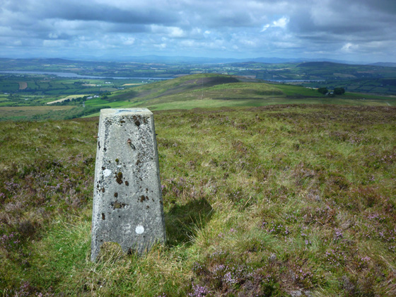
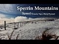
 C4517208351 starD. For such a short and easy walk up the views were spectacular. SE was the main Sperrins ridge while to the NW just across the River Foyle was Holywell Hill and Dooish Mountain with a great line of hills further back stretching from Inishowen around to the distant Derryveagh Mountains and more besides. This is a really excellent spot to while away an hour or so. When I was there I also walked out NNE for about 150 metres to another ring contour mentioned by three5four0 in his comments as possibly being higher
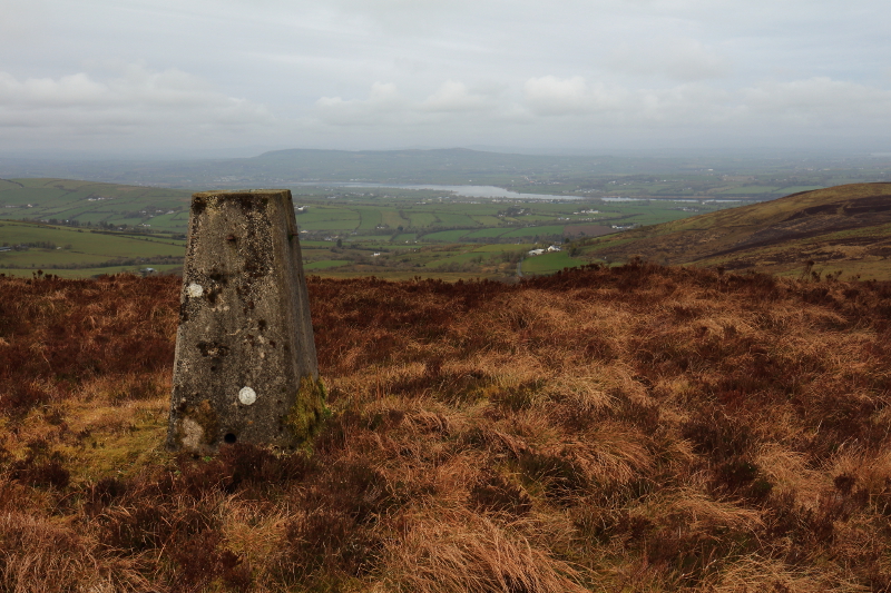
 C4537208429 starE, but both visually and by my very basic GPS reading it is slightly lower. When I was going across to this point I saw tracks made by heavy machinery and a number of marker posts in place which might suggest it is a site for yet another communications mast on this part of the hill to add to those already in situ about 2k to the E. I descended by way of ascent. Up and back was only 1.74k. On my way down I noticed a standing stone in the field leading down to the wooden gate and went a few metres off route to go and have a look C4514107964 starF. For anyone in the Derry area the three tops of Clondermot Hill, Gortmonly Hill and Slievekirk could all be visited in a morning or afternoon. For links see my comments on each of these hills. Linkback: https://mountainviews.ie/summit/877/comment/6031/
Your Score: Very useful <<  >>Average
 
MountainViews.ie Picture about mountain Slievekirk (<i>Sliabh Circe</i>) in area Sperrin Mountains, Ireland
Picture: Looking east along the Slievekirk motorway
The wind of change...
by Peter Walker  13 Mar 2011
I followed Mr Goodman's directions for an ascent from the south, having first checked out the possibility of coming in from the NW from the highpoint/road junction at (449 088 starG). This was comprehensively rejected; there are big changes afoot on this top. A huge windfarm is in the process of construction on the ridge to the E of Slievekirk, and the livid access road/track for those works (currently very busy with heavy plant vehicles and hard-hatted gentlemen) runs from that junction up onto the hill and along the crest. It passes within yards of the summit, but somehow doesn't seem very welcoming even if there was no objection to its use (I didn't ask).

My picture shows the extent of the workings; it's the view eastward from the 'ground to the NEE (of the trig point that) looks like it might be little higher!'. I'm unconvinced; I don't have any odd old Jackill-esque gadgets (and the webmaster laughed the last time I spoke of lying down and looking at lines of sight) but I think the trig point is marginally nearer the heavens. But for anyone who feels the need to visit both to be on the safe side...look both ways when crossing the road. Linkback: https://mountainviews.ie/summit/877/comment/6270/
Your Score: Very useful <<  >>Average
 
three5four0 on Slievekirk, 2009
by three5four0  23 Aug 2009
The hardest part of the ascent of Slievekirk is finding somewhere to park on the narrow roads around it. The tracks marked on the map, leading towards the summit are pretty over grown, with the exception of the track to the masts. Despite this, what ever side you tackle it is not long before you reach the summit (gaiters are advised as some of the lower ground has been churned up by cattle). The only question being is the Trig Point on the actual summit? Ground to the NEE looks like it might be little higher! Linkback: https://mountainviews.ie/summit/877/comment/4037/
Your Score: Very useful <<  >>Average
 
MountainViews.ie Picture about mountain Slievekirk (<i>Sliabh Circe</i>) in area Sperrin Mountains, Ireland
Picture: The River Foyle from the summit
 
Climb if nearby
by Aidy  2 Apr 2015
I followed Harry Goodman's route up from the south on the Castlewarren Road. At the trig, the gravel access road is very close, and I followed it east for about a kilometer to an another prominent rise on the hill. The work on the turbines seems to be finished, and it would now be possible to easily reach the top using the access road from the Bigwood Road, west of the summit. It was a grey, dull day when I visited, but the views are extensive, towards the Sperrins, along the Foyle, over Derry City and towards Binevenagh, although the hill is definitley dominated by all the turbines. Definitely worth the short walk if you're in the area, but I wouldn't make a journey specifically to bag it. Linkback: https://mountainviews.ie/summit/877/comment/17900/
Your Score: Very useful <<  >>Average
 
Wind Farm completed
by m0jla  23 Jun 2019
20/05/2019 The wind farm appears to be complete. Lots of parking space at point G (NW of summit) and a good road to follow until close to the summit. Linkback: https://mountainviews.ie/summit/877/comment/20559/
Your Score: Very useful <<  >>Average
 
(End of comment section for Slievekirk (Sliabh Circe).)

Main mapping:
Open Street Map
(Main supplier OpenTopoMap)
Height layer: © MapTiler
MapTiler Logo
British summit data courtesy:
Database of British & Irish Hills
(Creative Commons Licence)
MountainViews.ie, a Hill-walking Website for the island of Ireland. 2500 Summiteers, 1480 Contributors, maintainer of lists such as: Arderins, Vandeleur-Lynams, Highest Hundred, County Highpoints etc