Cookies.
This website uses cookies, which are small text files that the website puts on your device to facilitate operation. Cookies help us provide a better service to you. They are used to track general user traffic information and to help the website function properly.
Features
Nearby features appear when you click the map.
Declutter tracks on map.
Place Search
Video
X
Pub: by
Inishowen Area , NE: North East Inishowen Subarea
Feature count in area: 27, by county: Donegal: 27, Derry: 1, of which 1 is in both Derry and Donegal, OSI/LPS Maps: 2, 3, 4, 6, 7
Highest Place: Slieve Snaght 614.6m

Starting Places (43) in area Inishowen:
Adderville Upper, Barnes Bend, Bunacrick, Butlers Bridge, Carnaghan Presbyterian Church, Castruse Upper, Craignacoolagh, Craignamuck, Croaghglengad West, Crockavishane South, Diarmuid and Gráinne's Bed, Doherty's Dún, Dunree Bay Carpark, EEl Hole, Effishmore Upper, Evishbreedy Bridge, Five Fingers Strand, Gap of Mamore Grotto, Gap of Mamore Road, Gap of Mamore Viewpoint, Glack, Glasmullan, Golan Bridge Track, Goorey Hill, Grania's Gap, Gransha Árd, Green Hill, Leamacrossan Hill East, Lisfannon Beach, Lough Shivnagh, Lough Turk North, Magilligan Point View, Meenabroagh, Meenyollan River, Moor House, Mullagh, Pincher's Corner, Rashenny, Roosky Upper, Rowantree Hill, St Michael's Church, Stroove Beach, Tullagh Beach

Summits & other features in area Inishowen:
Cen: Slieve Snaght: Damph 420m, Slieve Main 514m, Slieve Snaght 614.6m
N: Malin: Croaghglengad 259m, Crockalough 282m, Soldiers hill 174m
NE: North East Inishowen: Crockavishane 322m, Crocknasmug 327.5m, Grinlieve 371m
NW: Urris: Binnion 250m, Bulbin 494m, Coolcross Hill 291m, Croaghcarragh 400m, Crockmain 460m, Dunaff Hill 230m, Mamore Hill 423m, Raghtin More 502m, Slievekeeragh 389m, Urris Hills 417m
S: Iskaheen: Crockglass 397m, Eskaheen Mountain 418m, Greenan Mountain 241m, Holywell Hill 260m, Inch Top 222m, Leamacrossan Hill 392m, Mouldy Hill 312m, Scalp Mountain 484m

Note: this list of places may include island features such as summits, but not islands as such.
Rating graphic.
Grinlieve, 371m Hill Cruinnshliabh A name in Irish,
Place Rating ..
(poss. Ir. Cruinnshliabh [PDT], 'round mountain'), Donegal County in Ulster province, in Binnion Lists, Grinlieve is the 1016th highest place in Ireland.
Grid Reference C48957 38427, OS 1:50k mapsheet 3
Place visited by: 21 members, recently by: eamonoc, Lucky1, trostanite, scottwalker, Fergalh, sandman, chalky, mark-rdc, jmcg, Hilltop-Harrier, Garmin, AntrimRambler, Harry Goodman, cerosti, NICKY
I visited this place: NO (You need to be a logged-in member for this.)
Longitude: -7.232147, Latitude: 55.190504, Easting: 248957, Northing: 438427, Prominence: 223m,  Isolation: 5.6km
ITM: 648895 938407
Bedrock type: Pale grey grit with psammitic schist, (Fahan Grit Formation)
Notes on name: Marked Crinlieve on the OS 1 map.
  Short or GPS IDs, 6 char: Grnlv, 10 char: Grinlieve

Linkback: https://mountainviews.ie/summit/876/
Gallery for Grinlieve (Cruinnshliabh) and surrounds
Summary for Grinlieve (Cruinnshliabh): An isolated small hill.
Summary created by Harry Goodman 2011-07-20 15:33:15
            MountainViews.ie picture about Grinlieve (<em>Cruinnshliabh</em>)
Picture: Grinlieve from the start of Route 1
Two routes are suggested. Route 1. Park at Goor Hl (C48048 37194) on left side of R240 coming from Moville. Room for several cars. Cross road and go NE, initially across a stream and then up and over a broad flat topped hillock. Continuing in same direction descend steeply, but briefly, to cross another stream and then go up a gully to an old stone walled enclosure. Just beyond this pick up a raised earthen ditch heading NNW. Follow its line up to a fence, turn right and follow the fence up to the top of the hill. Route 2. Park off road on the R240 A (C47850 37850) near a bridge. Walk NNW for some 300m along the road to a lane on the right B (C47810 38203). Follow the lane SE to cross a river, by stepping stones, and then go NNE keeping the hedgerow/bushes on the right and go up two fields to a fence, turn right and then a few metres along cross the fence and go up steeply through a patch of bracken to soon reach open ground. Keeping the fence line to the left follow it up for 1km to the top.
Linkback: mountainviews.ie/summit/876/comment/5635/
Member Comments for Grinlieve (Cruinnshliabh)
Comment create / edit display placeholder

            MountainViews.ie picture about Grinlieve (<em>Cruinnshliabh</em>)
Picture: view from top to Slieve Snaght
gerrym on Grinlieve
by gerrym 29 Sep 2009
Grinleive holds a sure presence, rising pyramid like to lord it over its immediate surroundings - before the biggest hills of Inishowen shout it down.
There is ample parking at 
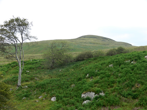
C (C482 371)where a forestry track leaves the road. Cross the busy road and drop down to an equally busy little river - may have to follow upstream to where it splts in two for an easy crossing. Climb up out of the river valley, past wonderfully posed trees and high ferns, to open hillside. Follow a fenceline gently up and then down into another river valley. This has a number of gullied streams crammed with clinging trees dropping down into it. A steep drop brings the small river and an equally steep rise starts the climb to the top of Grinlieve. Views already bring the height of Slieve Snaght and the commected tops of Sawel and Dart in the Sperrins to the S.

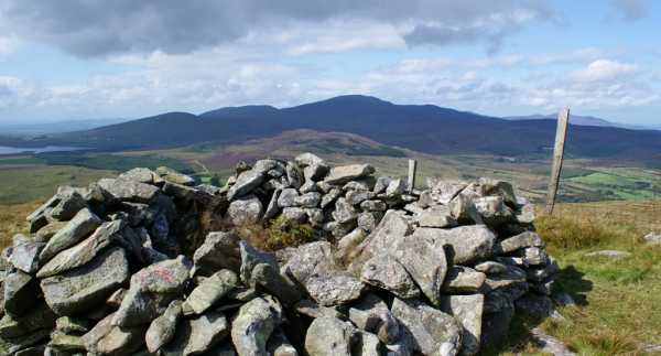
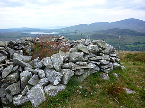
Grasshoppers fell silent as i approached, butterflies fluttered amongst the heather and ahead over the summit ravens circled. The partly cloudy sky created great contrasts of light and shade on the ground below - the blue waters of newly formed resevoir to the W were striking against the hillscape. On the top of neighbouring Creehennan Hill row upon row of white turf bags took on the menace of an army of crazed sheep massed to charge - i did have a couple of nervous glances just in case! The going is pretty good with evidence of rock nearer the top and hues of low purple heather. Top reached in 35 mins and 1.28 miles (1232 ft).

Views - i had a few! N & E to Malin Head then to Lough Foyle, Magilligan Strand, Antrim Hills and Scottish Islands. W & S to the rest of the hills of Inishowen, Derryveagh Mtns, Bluestack Mtns, possibly Sligo Hills and the Sperrins. The shelter cairn at the top provided time out of the rising wind to eat lunch as shower clouds gathered to the S.

Descend in a similar manner - the easy going giving time to savour the surroundings. All in all just over an hour walking and 2.5 miles. Easy start to a couple of days taking in the more isolated hills in the area. Linkback: mountainviews.ie/summit/876/comment/4161/
Read Less
Read More

            MountainViews.ie picture about Grinlieve (<em>Cruinnshliabh</em>)
Picture: Looking W to Slieve Snaght and the "unmapped" lake
Worthy of the climb.
by Harry Goodman 20 Jul 2011
Climbed this hill on 4 July 2011. I parked at Goor Hl (C48048 37194) where there was ample space for several cars. I crossed the R240 and then a small stream before heading up sharply NE to a broad flat moorland which I followed across before dropping down steeply, but not very far, to cross another stream. From there I went up a steep gully, past an out decaying tree and headed for the crest of the ridge . Before reaching the crest I came to an old walled stone enclosure and, shortly after, a raised ditch running NNW in the direction of Grinlieve Top. I followed it up and, when it became less distinct, continued on in the same direction to a fence where I turned right and followed it up the ridge to the small rounded top of the hill. This is a fine viewpoint with a substantial cairn, hollowed out to give shelter from the elements should needs dictate. Prominent due W were Slieve Snaght and its satellites of Slieve Main and Damph. Just left of these was the as yet "unmapped" lake on the OSI Sheet 3 (Edition 3). It reminded me of a walk some years ago when I was coming back from Slieve Snaght by way of Damph and became confused by a large lake ahead not shown on my map! From the top of Grinlieve, rather than return by way of ascent, I opted to follow the fence directly downhill. Near the bottom it became quite steep and I had to cross through a small patch of deep bracken to a fence which I crossed to a narrow but distinct track. I turned right along the track for a few metres and then turned left, keeping the hedge/bushes on my left, and went down through two fields to pick up a lane which forded a river and also had stepping stones, which I crossed and walked the short distance out to the R240 B (C47810 38203). I turned left and walked just over 1km back to the start. In all an enjoyable walk of some 4km which I combined with walks to two other isolated tops on the same day. Anyone considering using my descent route for an up and down should be aware that there is no parking available at the entrance to the lane off the main road. the nearest point to park would be some 300m along the road in the direction of Moville. Linkback: mountainviews.ie/summit/876/comment/6416/
Read Less
Read More

Fry by Day
by three5four0 18 Jul 2010
Followed gerrym's excellent route description and was up and down in no time. There was an impressive display of Orchids in the first section of the walk and other small SBT's. Thus we were able to fit in the current Mrs three5four0 wish, to visit a garden centre that afternoon.

Interestingly, said garden centre opens for breakfast at 9:00 am, and the size of the fry's being brought out were enough to tempt me to visit again, on our next drive north to Donegal. Its Ness Garden Centre by Ness woods on the A6, for those who have left home early to beat the traffic, without having breakfast. Linkback: mountainviews.ie/summit/876/comment/5957/
Read Less
Read More
EDIT Point of Interest
text
Videos


Recent Contributions
x
Conditions and Info
Use of MountainViews is governed by conditions and a privacy policy.
Read general information about the site.
Opinions in material here are not necessarily endorsed by MountainViews.
Hillwalking is a risk sport. Information in comments, walks, shared GPS tracks or about starting places may not be accurate for example as regards safety or access permission. You are responsible for your safety and your permission to walk.
See the credits and list definitions.

OSi logo
OSNI/LPS logo
Open Street Map
(Various variations used.)
British summit data courtesy:
Database of British & Irish Hills