Cookies.
This website uses cookies, which are small text files that the website puts on your device to facilitate operation. Cookies help us provide a better service to you. They are used to track general user traffic information and to help the website function properly.
Features
Nearby features appear when you click the map.
Declutter tracks on map.
Place Search
Video
X
Pub: by
Fermanagh & South Tyrone Area , W: Derrygonnelly Subarea
Feature count in area: 15, by county: Fermanagh: 9, Tyrone: 7, Monaghan: 1, of which 2 are in both Fermanagh and Tyrone, OSI/LPS Maps: 11, 17, 18, 19
Highest Place: Belmore Mountain 398m

Starting Places (15) in area Fermanagh & South Tyrone:
Aghanaglack, Carn Road, Carrickreagh Viewpoint, Crackrawer Road, Cullen Hill, Derrin, Dooletter, Largy S, Largy W, Lendrum Bridge Windfarm, Pollnagollum, Screggagh Windfarm, Slievemore, Tempo, Tullybrack

Summits & other features in area Fermanagh & South Tyrone:
Cen: Tempo Hills: Brougher Mountain 317m, Derrin 268m, Stranisk 312m, Topped Mountain 277m
E: Aughnacloy: Rehagy Mountain 194m
N: Largy: Largy 230m
NE: Ballygawley Hills: Cappagh Mountain 286m, Slievemore 314m
S: Slieve Beagh: Slieve Beagh 380m, Slieve Beagh SE Top 373m
W: Derrygonnelly: Belmore Mountain 398m, Cullen Hill 201m, Knockmore 277m, Legg 343m, Tullybrack 386m

Note: this list of places may include island features such as summits, but not islands as such.
Rating graphic.
Tullybrack, 386m Hill Tulaigh Bhreac A name in Irish,
Place Rating ..
(Ir. Tulaigh Bhreac [JOD*], 'speckled hillock'), Fermanagh County in Ulster province, in Binnion Lists, Tullybrack is the second highest hill in the Fermanagh & South Tyrone area and the 985th highest in Ireland.
Grid Reference H09000 45800, OS 1:50k mapsheet 17
Place visited by: 25 members, recently by: trostanite, dregish, LorraineG60, MichaelG55, m0jla, BogRunner1, seanmeehan, eamonoc, Garmin, IndyMan, Peter Walker, chalky, Fergalh, FEARGALS, mark-rdc
I visited this place: NO (You need to be a logged-in member for this.)
Longitude: -7.862335, Latitude: 54.360795, Easting: 209000, Northing: 345800, Prominence: 200m,  Isolation: 4.6km
ITM: 608947 845801
Bedrock type: Sandstone with subordinate argillaceous rocks & l, (Glenade Sandstone & Bellavalley Formation (undifferentiated))
Notes on name: The summit is located in the townland of Aghamore. The Discoverer Map shows the name Tullybrack to the NW and Mulderg to the SE. It is not clear which applies to this hill, if either, but the former has been chosen as it is slightly nearer. The hill Sliabh Dá Chon, mentioned in the Annals of the Four Masters, is a lower point in these uplands to the NW. Note that there is also a townland of Tullybrack or Ora More nearby, but this is lower down near Belcoo. Has been called Reyfad.
  Short or GPS IDs, 6 char: Tlybrc, 10 char: Tullybrack

Linkback: https://mountainviews.ie/summit/856/
Gallery for Tullybrack (Tulaigh Bhreac) and surrounds
No summary yet for this place .
Member Comments for Tullybrack (Tulaigh Bhreac)
Comment create / edit display placeholder

            MountainViews.ie picture about Tullybrack (<em>Tulaigh Bhreac</em>)
Picture: Tullybrack an undistinguished top
A pleasing variation to an out and back route
by Harry Goodman 30 Sep 2010
On Sat 25 Sept 2010 I turned off the minor road from Boho to Mullylusty at A (H097 423) signed for Aganaglack Dual Court Grave and parked just before an entrance gate to Ballintempo Forest AhnGlak (H09197 43040). Anticipating an out and back walk of some 16km I was surprised and pleased, just inside the gate, to note a board for a signed Aghnaglack Walk (12.3k). This coverd a major part of my intended outward route to Tullybrack and offered a circular walk which could then be followed after completing an out and back extension to Tullybrack about halfway around the waymarked trail, rather than an entire out and back route. It also had the advantage that it passed the Dual Court Grave on the return route. Initially I took the forest track due W for 3.2k to a junction B (H06316 44302), turned right and continued with this main track, with no turn offs, for about 3k to a fork in the track C (H07789 45411). The left branch of the fork was the start of the out and back section of my walk to gain the top of Tullybrack. I followed it along to its end at D (H09230 45638) where I turned left up a wide boggy firebreak in the trees for a few hundred metres to E (H09139 45891). From here the high point of the hill was clearly visable up to my left as a distinctive mound rising up from a large flatish area of treeless moorland. A surrounding cover of forestry in all directions restricted views but Cuilcagh and the Leitrim hills and Lough Erne were visable above the line of tree tops. The top was reached some 8k from the start. I retraced my route back to the fork in the track at C (H07789 45411) and rather than return from this point by my outward route opted to turn left and follow the signed Aghnaglack Walk (black arrows on stout wooden posts). The track eventually led down through the trees to open ground for fine views across to Cuilcagh and the Leitrim hills and a welcome relief after so much enclosed walking in the forest. Walkers should note that OSNI Sheet 17 (2008) shows this track stopping in trees near the Brimstone Rock with a dotted line extension beyond this point. This is not a true representation of what is on the ground as the quality of the track is maintained throughout back to the start and is mainly on open ground and not enclosed by trees. At a T junction F (H10292 44146) I turned right and followed the track along past tiny L Blocknet and a signed entrance path to the left for the Dual Court Grave (only 100 metres off route and well worth the visit). At the next T junction I turned left and was very soon back to the start. Total distance walked 15.2k in 3.5 hours. Apart from some open ground at the start and end the going was mainly through enclosed forest which I found somewhat tedious. Climbing is minimal and apart from a very short section of heather/boggy ground the route is all on very good forest tracks. Linkback: mountainviews.ie/summit/856/comment/6118/
Read Less
Read More

            MountainViews.ie picture about Tullybrack (<em>Tulaigh Bhreac</em>)
three5four0 on Tullybrack
by three5four0 4 Jan 2010
Just off the minor Boho to Mullylusty road, a track which is sign posted for the Giants Grave leads to a small area to park in, by a gate at AhnGlak (H092 430). if the gate is open there is further parking area, large enough for several cars just through the gate on the left, by a track junction.

From here, turn left (west) and walk several km to another track junction at G (H063 443), turning right here, shortly passing another track on your right, continue to the next junction by the Tullyscallen name on the map. Continue straight ahead and follow the track round a sharp right hand bend to another junction, this time taking the left hand branch, this junction when first arrived at doesn't seem to match the map, but it is the correct one. Follow this track to where it ends on the map at H (H092 457) (by the 386 height number on the map), the track continues on, but it is clear where the main track ends as the route starts to become over grown.

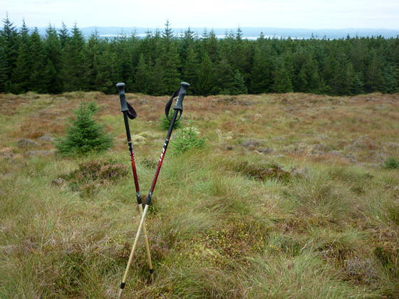
Look to your left and you should beside a fire break, follow this for about 250-290 metres and the summit should be clearly visible on your left, in an area of bog . The summit looks suspiciously like a buried Tomb, perhaps not surprisingly, given the amount of such sites in this area. The ground further west from the spot height, which looks higher, isn't. We visited & measured both by altimeter and the area at the spot height was the clear winner.

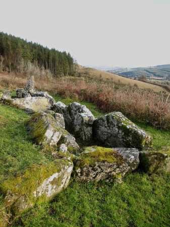
Return is by the way of ascent, however a visit to the double court tomb is a worthwhile objective and together with the summit makes a nice 11 mile stretch for the legs. Linkback: mountainviews.ie/summit/856/comment/4323/
Read Less
Read More
EDIT Point of Interest
text
Videos
Recent Contributions
x
Conditions and Info
Use of MountainViews is governed by conditions and a privacy policy.
Read general information about the site.
Opinions in material here are not necessarily endorsed by MountainViews.
Hillwalking is a risk sport. Information in comments, walks, shared GPS tracks or about starting places may not be accurate for example as regards safety or access permission. You are responsible for your safety and your permission to walk.
See the credits and list definitions.

OSi logo
OSNI/LPS logo
Open Street Map
(Various variations used.)
British summit data courtesy:
Database of British & Irish Hills