This website uses cookies, which are small text files that the website puts on your device to facilitate operation. Cookies help us provide a better service to you. They are used to track general user traffic information and to help the website function properly.
Feature count in area: 28, all in Kerry,
OSI/LPS Maps: 78, 79, EW-KNP, EW-R
Highest Place: Mangerton 838.2m
Starting Places (30) in area Mangerton: Cummeenboy Stream, Derrycunihy Church, Dunkerron Mid, Garries Bridge, Gowlane School Ruin, Hidden Valley Pet Farm, Inchimore West, Kenmare Bridge, Killarney Hiking Parking Lot, Knockanaskill N, Knocknsallagh Bridge, Loo River Junction, Looscaunagh Lough W, Lough Barfinnihy CP, Lough Guitane E, Lough Guitane SE, Lough Guitane W, Lynes Farm, Mangerton Walk N CP, Mangerton Walk Start, Molls Gap, Muckross Lake S, Old Rail Level Crossing, Poulacapple, River Roughty, Rossacroo na Loo Forest, Sahaleen Bridge, Shaking Rock W, Shronaboy Farm MTB, Torc Waterfall CP
Summits & other features in area Mangerton: Cen: Dromderlough: Dromderalough 650m, Dromderalough NE Top 654m, Dromderalough NW Top 625m, Knockbrack 610m, Knockrower 554m, Shaking Rock 402m Cen: Inchimore: Inchimore 256m Cen: Mangerton: Glencappul Top 700m, Mangerton 838.2m, Mangerton North Top 782m, Stoompa 705m, Stoompa East Top 608m NE: Crohane: Bennaunmore 454m, Carrigawaddra 425m, Crohane 650m, Crohane SW Top 477m NW: Torc: Cromaglan Mountain 371m, Torc Mountain 534.8m, Torc Mountain West Top 479.4m SE: Esknabrock: Esknabrock 406m SW: Peakeens: Derrygarriff 492m, Derrygarriff West Top 382m, Foardal 409.8m, Knockanaguish 509m, Peakeen Mountain 554.7m, Peakeen Mountain Far NW Top 525.5m, Peakeen Mountain North-West Top 522.7m, Peakeen Mountain West Top 538.7m
Note: this list of places may include island features such as summits, but not
islands as such.
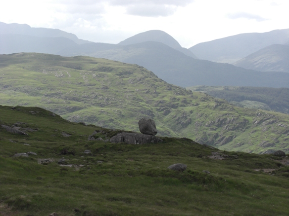
Shaking Rock, 402mHill
Place Rating ..
, Foiladore, Kerry County in Munster province, in no lists, Shaking Rock is the 934th highest place in Ireland.
Grid Reference V92794 79277,
OS 1:50k mapsheet 78 Place visited by: 36members, recently by: garrettd, Krzysztof_K, peter1, Grumbler, Ulsterpooka, ciarraioch, annem, chelman7, daitho9, Fergalh, David-Guenot, Wilderness, Wildrover, eamonoc, thomas_g
I visited this place: NO (You need to be a logged-in member for this.)
You can pretty much head in a direct line from the top of Knockrower to Shaking Rock, just detouring slightly to avoid the occasional small cliff. The re-ascent up just makes the Mountain Views criteria - 31m by my GPS.
The summit is flat and boggy. Hard to determine the exact high point, there are 2 or 3 candidates. I wonder is the boulder in the picture the rock that shakes? It was fairly stationary when I as there. To descend and return to Galway's Bridge I took the route 'Kenmare Uplands' as described by Kevin Corcoran in his book 'Kerry Walks'. This takes you past the Poulagower falls and follows the Galway's river back to the Kerry Way and the Old Kenmare Road.
Kevin describes this part of the route as "difficult and extremely demanding, and if the river is in flood it can be tortuous!" It had been exceptionally dry when I did it, and it was bad enough. If you're looking for Wilderness, remoteness and isolation this will be right up your street. I doubt even Simon's magic phone would get a signal here. Linkback: mountainviews.ie/summit/822/comment/3857/
Read Less
Read More
Conor74 on Shaking Rock
by Conor74
29 Jun 2009
Would add one other point to the above. Even if not walking from the top of Knockrower, stick as near as possible to the base, there is a road (really a track that can be difficult to make out) depicted on the area map which passes Cummenslaun Lake and A (V925 774), goes north skirting the bottom of Knockrower before turning north east at B (V929 787) through the saddle between that mountain and Shaking Rock. If one strays from this, the going can be tough. The area to the west, being east of the Old Killarney Road, is covered in ferns that can be up to 6 feet high, acres and acres of grass that is ungrazed and also up to waist height, with enopugh rocks and tufts to test the ankles, areas that are conserved woodlands and so fenced off with high deer proof fence, and is just a very slow and difficult walk. Linkback: mountainviews.ie/summit/822/comment/3891/
Use of MountainViews is governed by conditions and a privacy policy.
Read general information about the site. Opinions in material here are not necessarily endorsed by MountainViews.
Hillwalking is a risk sport. Information in comments, walks, shared GPS tracks or about starting places may
not be accurate for example as regards safety or access permission. You are responsible for your safety and your permission to walk.
See the credits and list definitions.


 Our Facebook page.