This website uses cookies, which are small text files that the website puts on your device to facilitate operation. Cookies help us provide a better service to you. They are used to track general user traffic information and to help the website function properly.
Feature count in area: 44, by county: Tipperary: 36, Limerick: 8,
OSI/LPS Maps: 52, 53, 54, 58, 59, 60, 65, 66
Highest Place: Keeper Hill 691.6m
Starting Places (31) in area Midlands SW: Ballincurra Hill South, Ballyhourigan Wood Loop Walk, Barnane Lodge, Castlewaller Wood Forest Road, Coillte Knockanroe, Commanealine Wood, Commaun Beg North, Cullaun South, Cummer South, Curreeny Wood, Doonane Forest Carpark, Foildhine Mulkeir Rivers, Glenaneagh Park, Glenstal Wood CP, Gortagarry Hill West, Greenan Cross, Knockadigeen Hill SW, Knockanora East, Knockanully, Knockaviltoge East, Knockfune Wood Bend, Knockmaroe Wood, Knockmehill South, Knockteige SW, Nicker, Raven's Rock, Ring Hill West, River Doonane, The Lookout, Tobernagreana, Upperchurch
Summits & other features in area Midlands SW: Cen: Mauherslieve: Cummer 405m, Foilduff 400m, Knockmaroe 411m, Mauherslieve 543m E: Upperchurch Hills: Knockalough 427m, Knockaviltoge 364m N: Knockshigowna: Knockshigowna 212m NE: Devilsbit: Benduff 455m, Black Hill 228m, Devilsbit Mountain 480m, Gortagarry 458m, Kilduff Mountain 445m, Knockanora 433m NE: Templederry: Ballincurra Hill 403m, Commaun Beg 403m, Cooneen Hill 467m, Coumsallahaun 320m, Knockadigeen Hill 402m NW: Arra Mountains: Corbally Hill 339m, Tountinna 457m NW: Silvermine Mountains: Silvermine Mountains East Top 479m, Silvermine Mountains Far East Top 410m, Silvermine Mountains West Top 489m SE: Hollyford Hills: Falleennafinoga 388m, Foildarg 440m, Glenaneagh 420m, Gortnageragh 418m, Knockastanna 444m, Knockbane 433m, Lackenacreena 413m, Ring Hill 426m, Tooreen 457m SW: Slieve Felim: Cullaun 460m, Derk Hill 236m, Knockroe 204m, Knockseefin 235m, Slieve Felim 427m, Slieve Felim East Top 423m, Slieve Felim South Top 407m W: Keeper Hill: Bleanbeg 368m, Boolatin Top 446.6m, Keeper Hill 691.6m, Knockane 411m, Knockfune 452m
Note: this list of places may include island features such as summits, but not
islands as such.
Ballincurra Hill, 403mHill Cnoc Bhaile an Charraigh A name in Irish,
Place Rating ..
(Ir. Cnoc Bhaile an Charraigh [OSI], 'hill of Baile an Charraigh'), Tipperary County in Munster province, in Carn Lists, Ballincurra Hill is the 929th highest place in Ireland.
Grid Reference R92433 69802,
OS 1:50k mapsheet 59 Place visited by: 40members, recently by: Moirabourke, Arcticaurora, Krzysztof_K, JohnRea, Dee68, Colin Murphy, garrettd, LiamG1951, High-King, sarahryanowen, Mugg, maryblewitt, mlmoroneybb, LorraineG60, MichaelG55
I visited this place: NO (You need to be a logged-in member for this.)
Longitude: -8.112911, Latitude: 52.779542, Easting: 192433, Northing: 169802,
Prominence: 188m, Isolation: 1.5km ITM: 592382 669841 Bedrock type: Greywacke, siltstone & grit, (Hollyford Formation) Notes on name: The gap between Ballincurra Hill and Cooneen Hill is known as Ormond Stile (sometimes Ormond Style). It is mentioned by John O'Donovan as the northern limit of Sliabh Eibhlinne (Slieve Felim), and he calls it Céim Urmhumhain, 'the step of Ormond'. It is on the southern boundary of the barony of Upper Ormond.
Short or GPS IDs, 6 char: Bln403, 10 char: BlncrHil Linkback: https://mountainviews.ie/summit/814/
Gallery for Ballincurra Hill (Cnoc Bhaile an Charraigh) and surrounds
Summary
for Ballincurra Hill (Cnoc Bhaile an Charraigh):
Ballincarra
Summary created by simon3, aidand
2012-10-15 12:39:05
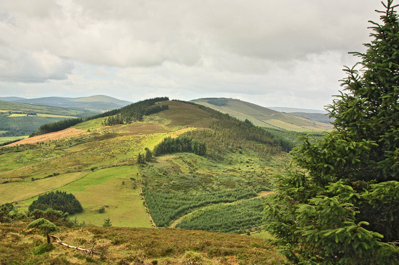
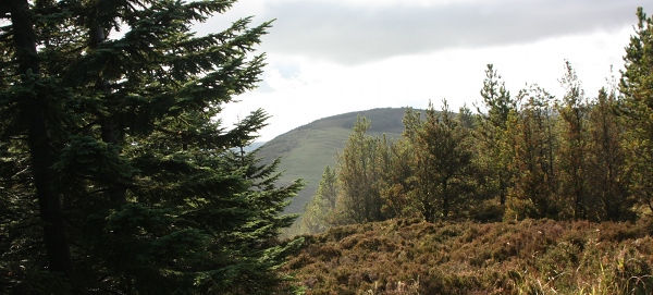
Picture: Ballincurra from the NE.
The locals tell me this is really known as Ballincarra, rather than Ballincurra. Jackills description below provides all you need to know about this relatively easy climb. There is plenty of parking at the forest entrance at Bl'Cura Hl (RBl'Cura Hl (R924 692)) - this is on the Templederry to Dolla Road. The area here is known as Ormond Stile. Daniel O'Connell is said to have held one of his 'Monster Meetings' here in the 19th Century. Follow the forest road for about 20 minutes and then turn right at A (R916 705). Follow this track to the end and then head up the hill in front of you.
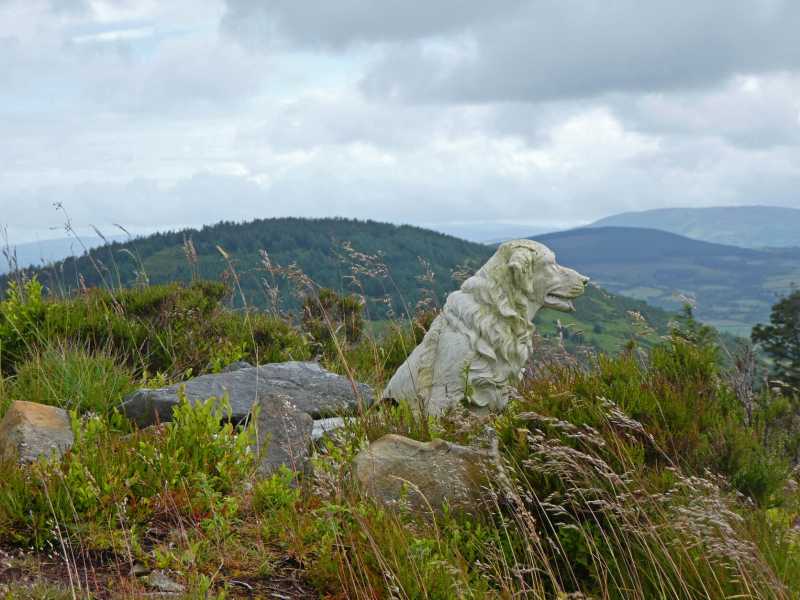
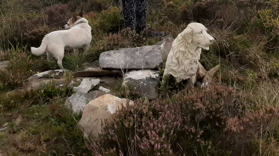
Other contributors have remarked on the curious porcelain dog marking the summit, speculating that it might be a memorial to a beloved pet. Well, it's not. As my daughter & 1 descended we encountered an elderly local gentleman walking a dog and I asked him about the porcelain canine. He told us that he regularly walks there and one day he discovered that some lout had dumped a load of rubbish on the track, said rubbish including the dog. He removed the rubbish but decided to carry the large ornament to the summit and leave it there as a curiosity. So ends one minor mountain mystery! Linkback: mountainviews.ie/summit/814/comment/23571/
Read Less
Read More
Picture: Looking north to Knockadigeen and the Devilsbit
jackill on Ballincurra Hill
by jackill
28 Mar 2010
It was a joy to find a track to within 200 meters of the summit. Start at the forestry entrance at Bl'Cura Hl (R92461 69235) and turn right at B (R91658 70512) and you'll have an easy time until the last push through heather and sedge grass.The hillfort here is more defined than on nearby Knockadigeen. Linkback: mountainviews.ie/summit/814/comment/4550/
Read Less
Read More
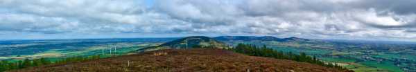
Picture: Pastoral views from Ballincurra
peterturner on Ballincurra Hill
by peterturner
6 Apr 2008
Ballincurra summit is easy to reach from forest entrance on road west of Templederry rBl'Cura Hl (R924 692) . Make ascending zig zags choosing forest paths that ascend and you won't go wrong. There has been much recent felling both here and on its neighbour Cooneen Hill. The summit has a very small hillfort (as does another neighbour Knockadigeen) and there are some wonderfully bucolic views to be had although Keeper Hill is less viewable than on Cooneen Hill. Allow 1 hour to reach the summit from point A. There is also a small spur from Ballincurra with a forest track ringing it which would make for a more substantial walk in the area. Linkback: mountainviews.ie/summit/814/comment/3028/
Read Less
Read More
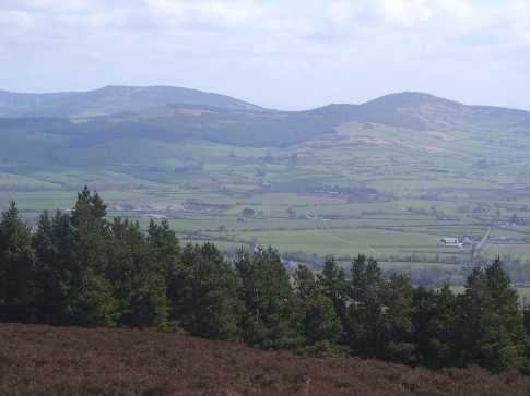
Picture: Cooneen Hill, visible through the trees from the summit of Ballincurra Hill
csd on Ballincurra Hill
by csd
12 Oct 2009
Having completed the easy trot up and down from Knockadigeen (see my comment there for parking info), I headed SW for Ballincurra. The shortest obvious route appeared to be a direct route up, keeping the Coillte forest to the right and the open fields to the left. I stopped in at the house adjoining my planned route up and asked if it was ok for the dog and me to skirt their fields on the way up: no problem came the answer. After negotiating a fence, the last 400 metres before reaching the summit is across knee-to-waist-high heather. Not too pleasant, and quite tiring. Once on top, Lough Derg is visible to the far north, with the view SW partially obscured by plantation. Linkback: mountainviews.ie/summit/814/comment/4202/
Read Less
Read More
A forest ramble
by High-King
5 Sep 2021
I started in Templederry and took the road marked Dolla, I drove to the forestry entrance about 2km on my right hand side, Parking for 3 to 4 cars. Step over the forestry barrier and follow the good track uphill. After 20 minutes there is a sign on your right "burial ground". This is not the turn to take. Go another five minutes and the road splits. Take the road to the right and uphill. After a bit the track tops out and starts to become narrow. When the track ends the mountain isc250m on the left. For some reason the summit is marked by a Delph white dog. Linkback: mountainviews.ie/summit/814/comment/23265/
Use of MountainViews is governed by conditions and a privacy policy.
Read general information about the site. Opinions in material here are not necessarily endorsed by MountainViews.
Hillwalking is a risk sport. Information in comments, walks, shared GPS tracks or about starting places may
not be accurate for example as regards safety or access permission. You are responsible for your safety and your permission to walk.
See the credits and list definitions.


 Our Facebook page.