Cookies.
This website uses cookies, which are small text files that the website puts on your device to facilitate operation. Cookies help us provide a better service to you. They are used to track general user traffic information and to help the website function properly.
Features
Nearby features appear when you click the map.
Declutter tracks on map.
Place Search
Video
X
Pub: by
Antrim Hills Area , N: North Antrim Hills Subarea
Feature count in area: 27, all in Antrim, OSI/LPS Maps: 14, 15, 4, 5, 8, 9
Highest Place: Trostan 550m

Starting Places (3) in area Antrim Hills:
Donalds Carn, Rathlin Island Ferry Port, Whitehead Golf Club

Summits & other features in area Antrim Hills:
Cen: Central Antrim Hills: Carncormick 436m, Collin Top 429m, Crockalough 402m, Mid Hill 440m, Skerry Hill 459m, Slieveanorra 508m, Slievenahanaghan 418m, Soarns Hill 403m, Tievebulliagh 402m, Trostan 550m
Central Antrim Hills: Slievenanee 543m
N: North Antrim Hills: Carnanmore 379m, Croaghan 417m, Crockaneel 403m, Cross Slieve 206m, Knocklayd 514m, Lannimore Hill 207m
N: Rathlin Island: Kilpatrick (Rathlin Island) 134m
S: Islandmagee: Donalds Carn 141m, Muldersleigh Hill 131m
S: South Antrim Hills: Agnew's Hill 474m, Big Collin 353m, Black Hill 381m, Carnearny 319m, Douglas Top 402m, Slemish 437.9m
W: West Antrim: Long Mountain 215m

Note: this list of places may include island features such as summits, but not islands as such.
Rating graphic.
Crockaneel, 403m Hill Cnoc an Aoil A name in Irish,
Place Rating ..
(Ir. Cnoc an Aoil [PNNI], hill of the lime'), Antrim County in Ulster province, in Carn Lists, Crockaneel is the 931st highest place in Ireland.
Grid Reference D19100 33800, OS 1:50k mapsheet 5
Place visited by: 32 members, recently by: Paddym99, garybuz, Colin Murphy, Carolyn105, Kilcoobin, LorraineG60, MichaelG55, eamonoc, Fergalh, killyman1, Ulsterpooka, Wilderness, stevebullers, trostanite, Peter Walker
I visited this place: NO (You need to be a logged-in member for this.)
Longitude: -6.133277, Latitude: 55.137065, Easting: 319100, Northing: 433800, Prominence: 88m,  Isolation: 5.7km
ITM: 719023 933781
Bedrock type: Psammite & semipellite, (Runabay Formation)
Notes on name: Also recorded as Glenmakeerin Top in an Ordnance Survey Revision Name Book, Glenmakeerin being the valley to the north which lead down towards Ballycastle.
  Short or GPS IDs, 6 char: Crc403, 10 char: Crockaneel

Linkback: https://mountainviews.ie/summit/811/
Gallery for Crockaneel (Cnoc an Aoil) and surrounds
Summary for Crockaneel (Cnoc an Aoil): A very long walk in the woods
Summary created by Colin Murphy 2022-09-23 16:01:31
            MountainViews.ie picture about Crockaneel (<em>Cnoc an Aoil</em>)
Picture: The unlovely Crockaneel from the point where the track ends
This route involves a long walk through the woods - almost 12km return trip. Start at the entrance to Ballypatrick Forest at A (D19461 37059) where there is a large parking area. This is occasionally driveable but the forest road seems to be closed more often than not, so plan for a long walk. Follow the forest track south along a stream, which then turns SW under the A2. Proceed along this for about 500m where it meets a second forest track. Turn left for about 200m to point B (D19809 35533), then turn right and continue SW for about 2.5km. The track deteriorates a bit and swings around to a SE direction, cuts up through the edge of the forest and eventually comes to an end on the open hillside about 500m from the highpoint at C (D18523 33647). From then on it's a slog directly east through spongy heather, long grass and peat hags. The highpoint is difficult to define, and several spots vie for the title, all near to a fence that crosses the flattish summit. Allow 3 hours up and down.
Linkback: mountainviews.ie/summit/811/comment/5570/
Member Comments for Crockaneel (Cnoc an Aoil)
Comment create / edit display placeholder

            MountainViews.ie picture about Crockaneel (<em>Cnoc an Aoil</em>)
Picture: Knocklayd from the top of Crockaneel
Harry Goodman on Crockaneel
by Harry Goodman 12 Dec 2009
Climbed Crockaneel on 10 December 2009 by the route described in three5four0's summit comments. To avoid at least some tarmac we followed the signed Corratavey Glen Trail high level path to Corratavey Bridge. This is a walk well suited to a short winter day. While we went out and back by three5four0's route it would be possible on the way down to extend the walk by continuing around by the Ballypatrick Forest Drive and completing the full 6 miles back to the car park. The Glens of Antrim Activity Map 1 : 25,000 shows the various paths. This would have the advantage of passing an ancient Horned Cairn on the way. The summit of Crockaneel is flat with numerous small ponds. The views are extensive around a full 360 degrees. When we were there the Mull of Kintyre was especially clear lit by a bright winter sun. In comments three5four0 gives a map reference at a fence which crosses the summit area as a useful navigational aid in foul weather. I find it hard to imagine why anyone would want to climb Crockaneel in such conditions! This said I would also suggest that, whatever the weather, walkers include a map reference for the end of the path where it leads out on to the open hillside D (D18528 33645). Given the flat featureless top of the hill it might not be easy to find the way back to the start of this path on the way down, especially if one wanders around on the top. One final thought, it may appeal to some walkers to approach this hill directly from the A2 near Loughareema starting at E (D21000 34850) and following the fence SW for just over two kilometres to the top. However as I have not attempted this route I cannot give any information as to the underfoot conditions one might expect to find. Linkback: mountainviews.ie/summit/811/comment/4286/
Read Less
Read More

            MountainViews.ie picture about Crockaneel (<em>Cnoc an Aoil</em>)
Picture: snow drifts at summit
What a Crock!
by gerrym 12 Jun 2010
The obvious starting point is the plentiful carpark at the start of the forest drive through Ballypatrick Forest. Walk back onto the A2, turning left and crossing Bushburn and Alteela bridges, before taking a forest track uphill on the right.

The recent heavy dump of snow had left 3-4" of wet stuff which was well trodden through the forest. Much slipping and sliding brought a crossroads in the forest tracks. Options are many and the 1:25 000 map could give hours of pleasure in walking the tracks here. The sunlight tempted me and i turned left to follow a straight path into the distance. The track had been crossed at regular points by animal prints -much fun speculating as to what?

The forest drive joins from the left and the tyre tracks of a 4x4 eased the walking in the snow. A track turns off to the right just before a gate and this is followed for over 2km. There are a couple of scenic picnic tables - the first with views to the top of Carneighaneigh (317m) and the second to the more expansive and impressive Knocklayd. I stopped at the first to sit at the picnic table in the surreal scene with snow blanketing the ground. Clearfell brings views of Knocklayd and Rathlin Island and along Glenshesk to the distant northern Sperrins. Cross a gate, where the track lay free of prints until three sets of boots sunk into the now easily 6" of snow. A steady rythm brought a strange enjoyment in plodding through the snow.

At the end of this track a turn uphill to the left climbs steeply through the trees. The snow became progressively deeper with height, reaching 1ft deep as trees came suddenly to life when thier large burdens of snow succumbed to the rising temperatures of a winter sun.

The open hillside come suddenly and brings stunning views north to the north coast. Much attention was taken up closer with the 3-4 ft drifts which filled in and levelled the hillside. This provided great craic to see who would sink deepest when passing over! A compass bearing picked up the fenceline crossing the summit and brought the kink at its highest point. The views were stunning to the arctic looking summits of the other high hills in Antrim, along the northh coast and across to the snow topped hills on the coast of Scotland. The ditch to the side of the fence was impressively filled with deep drifted snow. Top reached in 5km and 1.75 hours.

Followed the fence downhill to the NE towards the A2. This was pretty good going through the deep snow, though i suspect the ground is deep and tussocky in places, as well as the peat hags - just couldn't tell with the snow. Followed the high ground above the road to Loughareema - The Vanishing Lake, which was pretty full today. A number of old tracks can be followed here and they eventually drop to the road just before enters the forest. At Corratavey Bridge can drop down and follow the forest drive or the Corratavey Glen Trail back. In all 10.5 km and 3.5 hours of movement. Linkback: mountainviews.ie/summit/811/comment/4474/
Read Less
Read More

three5four0 on Crockaneel
by three5four0 22 Jan 2009
There is a parking area at the start of the Ballypatrick Forest Drive, just off the Cushendall Road (A2), at F (D195 370). From the carpark you can either follow the forest drive road, which is closed to traffic in winter, or follow a marked trail above the road, both join again at the ford below Corratavey Bridge where you pass beneath the Cushendall Road. The Glens of Antrim Activity Map @ 1:25000 scale shows the forestry tracks here clearly & includes tracks not shown on the 1:50000 version (including the one we are taking onto the hill). On our visit, described below, we were lucky to have a dusting of snow, which made up for the previous days gales on Donalds Hill.

After crossing under the road we reached a track junction after 500 metres, turning left to stay on the forest drive and right at the next junction. We continued to follow the Forest Drive round to a junction at G (D183 346), & continue straight ahead (now off the drive) to a bend in the track and another track junction at H (D180 342). We turned left here and followed this track uphill in a south easterly direction, & after about 750 metres reached the open hillside.

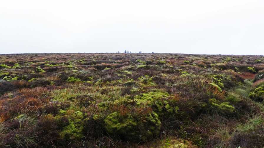
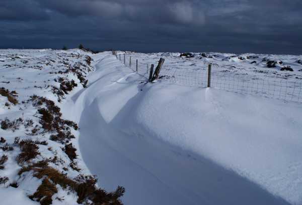
Although walking through the forest in the snow was quite pleasant, walking across the hillside with the wind driving it into your face was not. Luckily the snow, like the first peat hags after the forest, didn't last for long, with the sky clearing to give superb views of Rathlin and the north coast with its dusting of snow. There is a fence that crosses the summit area, with a newly dug drainage ditch before it to negotiate as well. A kink in the fence at I (D190 337) could be a useful navigational aid in foul weather. After crossing both the ditch, fence and avoiding the several small ponds, the spot height marked on the map, certainly appears to be lower than the ground you have just crossed to get to it. Also, the ground to you left (looking back to the forest) now appears to be slightly higher than where you are now standing as well. After walking round in a wide circle, to cross all these points and take in the views, its safe to head for home by the way of ascent. In my case, that means a stop off at the Barbican pub in Glenarm, which serves one of the truly great pints of Guinness you will find in the Glens. Linkback: mountainviews.ie/summit/811/comment/3541/
Read Less
Read More
EDIT Point of Interest
text
Videos


Recent Contributions
x
Conditions and Info
Use of MountainViews is governed by conditions and a privacy policy.
Read general information about the site.
Opinions in material here are not necessarily endorsed by MountainViews.
Hillwalking is a risk sport. Information in comments, walks, shared GPS tracks or about starting places may not be accurate for example as regards safety or access permission. You are responsible for your safety and your permission to walk.
See the credits and list definitions.

OSi logo
OSNI/LPS logo
Open Street Map
(Various variations used.)
British summit data courtesy:
Database of British & Irish Hills