Cookies.
This website uses cookies, which are small text files that the website puts on your device to facilitate operation. Cookies help us provide a better service to you. They are used to track general user traffic information and to help the website function properly.
Features
Nearby features appear when you click the map.
Declutter tracks on map.
Place Search
Video
X
Pub: by
Mizen/Sheeps Head Area , NE: Mizen NE Subarea
Feature count in area: 19, all in Cork, OSI/LPS Maps: 84, 85, 88, 89
Highest Place: Mount Gabriel 407m

Starting Places (14) in area Mizen/Sheeps Head:
Ahakista Pier, Brow Head Watch Tower, Cahergal, Carr Clós Dún Óir, Coosacuslaun Bay, Derrylahard East, Durrus Village, Kilcrohane, Letter Cillin CP, Mount Corrin Road, Mount Gabriel Road, Sheeps Head Turning Point, Sherkin Island Pier, Sui Finn Car Park

Summits & other features in area Mizen/Sheeps Head:
NE: Mizen NE: Derrylahard East 301m, Knockaughna 268m, Mount Corrin 284m, Mount Gabriel 407m, Mount Kid 296.1m
NW: Sheeps Head: Ballyroon Mountain 239m, Caher Mountain 338m, Fahane 233m, Gouladane 303m, Seefin 345m
S: Cape Clear: Cnoicín an tSeabhaic (Clear Island) 160m
S: Knockomagh: Knockomagh 197m
S: Sherkin: Slievemore (Sherkin Island) 101m
SW: Mizen SW: Brow Head 108m, Knockaphuca 237m, Knockatassonig 207m, Knocknamaddree 313m, Lackenakea 164m, Mizen Peak 232m

Note: this list of places may include island features such as summits, but not islands as such.
Rating graphic.
Mount Gabriel, 407m Hill Cnoc Osta A name in Irish,
Place Rating ..
(Ir. Cnoc Osta [logainm.ie], poss. 'hill of the encampment'), Cork County in Munster province, in Carn Lists, Mount Gabriel is the highest hill in the Mizen/Sheeps Head area and the 914th highest in Ireland.
Grid Reference V93118 34864, OS 1:50k mapsheet 88
Place visited by: 86 members, recently by: annem, nickywood, Taisce, chelman7, bryanjbarry, jackos, caiomhin, JohnAshton, liz50, BillWatson, roops, tfm9, John_Murphy, Jimbo70, TommyMc
I visited this place: NO (You need to be a logged-in member for this.)
Longitude: -9.541851, Latitude: 51.556845, Easting: 93118, Northing: 34864, Prominence: 312m,  Isolation: 4km, Has trig pillar
ITM: 493088 534936
Bedrock type: Purple mudstone and siltstone, (Castlehaven Formation)
Notes on name: Mount Gabriel was an important source of copper in the Early Bronze Age, with more than 30 mines having been found on its southern slopes, consisting of small tunnels dug into the mountainside. These are remarkably well preserved since they were mostly covered over by massive bog growth, leaving them untouched since the miners of the Early Bronze Age abandoned them [Daphne Pochin Mould, Discovering Cork]. The area was excavated in 1985 by William O'Brien, who judges that the mining was on such a large scale that it cannot have been merely for use in Ireland, but rather that the copper was mainly exported to Europe. The Irish name of the hill recorded by Bruno O'Donoghue in his Parish Histories and Placenames of West Cork is Cnoc Fhosta, 'hill of the encampment'.
  Short or GPS IDs, 6 char: MntGbr, 10 char: MntGbrl

Linkback: https://mountainviews.ie/summit/792/
Gallery for Mount Gabriel (Cnoc Osta) and surrounds
Summary for Mount Gabriel (Cnoc Osta): Access Rd to top
Summary created by paddyhillsbagger 2010-10-09 14:05:58
            MountainViews.ie picture about Mount Gabriel (<em>Cnoc Osta</em>)
Picture: Access road to giant golfballs
The Irish Aviation Authority have kindly provided an access road to their golfball shaped domes on the top of Mt Gabriel at A (V930 356) . The trig is only a short walk round the side of the first dome. You can drive up (as long as your car doesn't overheat like mine leaving me to walk the final bit before topping up with water) or walk. The views are magnificent on a clear day. Well worth it, regardless of method used.
Linkback: mountainviews.ie/summit/792/comment/5551/
Member Comments for Mount Gabriel (Cnoc Osta)
Comment create / edit display placeholder

            MountainViews.ie picture about Mount Gabriel (<em>Cnoc Osta</em>)
Picture: Probably the easiest summit in Ireland?
There is a God and he left the gate open!
by jackill 3 Jun 2010
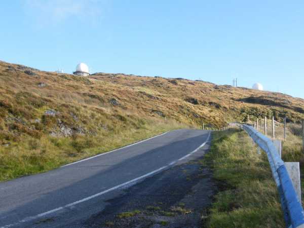
Wet wet wet, wet to the skin, wet to the bone, 100% water I was. But there was only one left. Will I? won't I?, sure I'll go and have a look at the Aviation authority roadway, the one marked on the map on the north side of the hill.Ah Jaysus! the gates open! how fast can I drive up and down,
4 minutes to climb 220 meters.
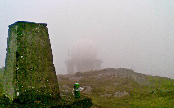
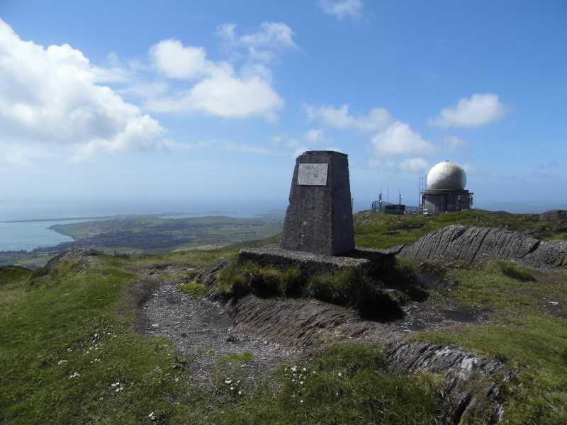
And best of all, someone left me a Beer.
The preacher Caeser Otway travelling in this area in 1822 wrote
"On my way to Bantry I passed the dark and lofty Mount Gabriel and took my way over a dreary, comfortless tract of country.
Let no one say after looking at these moors , studded over with cabins crowded with children, pigs, goats, cocks and hens that a poor Irishman is not an industrious creature.
Men,women, boys and girls toiling up the mountainside with seaweed and sea sand,in baskets on their backs.
See them reclaiming from amidst rocks and bogs, patches of ground on which to cultivate their only food, the potato; And no one witnessing this struggle of human industry against nature, but must acknowlege that the Irish can be industious." Linkback: mountainviews.ie/summit/792/comment/5844/
Read Less
Read More

            MountainViews.ie picture about Mount Gabriel (<em>Cnoc Osta</em>)
Picture: Taken from the west in the Cahas.
Illustrating how it bulks over the surrounding land.
by simon3 1 Nov 2012
Mount Gabriel is very distinctive high ground in the Mizen/ Sheeps Head area, particularly because of the white radomes on top.

This picture was taken from Knocknagree 25.80km away in the Cahas, Linkback: mountainviews.ie/summit/792/comment/14851/
Read Less
Read More

            MountainViews.ie picture about Mount Gabriel (<em>Cnoc Osta</em>)
Picture: Entrance to one of the Bronze Age mines
A Bronze Age Hive of Activity
by kernowclimber 26 Nov 2011
Bishop Dives Downes, visiting Mount Gabriel around the turn of the C18th, a place of great natural beauty with extensive views over Roaringwater Bay, described the mountain as ‘… a haunt of wolves; there are no trees nor shelter except rocks and bogs’. He would have been unaware that the mountain has much more to commend it than just fantastic scenery. For scattered amid the rocks and blanket bog of the mountain’s eastern and southern slopes, are the remains of over 30 individual copper mines driven in sedimentary (old red sandstone) copper beds invaded by quartz veins. These date from between 1700 and 1500 BC in the Bronze Age.

Ireland was one of the main sources of Bronze Age copper which was used in the production of various metal items including axes, the high status symbols of their day, and Mount Gabriel was one of a number of sites that were once hives of industrial activity. Excavations here by one of Europe’s foremost Bronze Age archaeologists, William O’Brien of Galway University, has revealed evidence of mine workings, spoil heaps, mineral processing areas, stone axe manufacture and wood preparation areas. Artefacts recovered from inside the Mount Gabriel workings include smooth oval shaped stone mauls used to excavate the rock. These would have been specially transported inland from the coast some 4 km away. Fragments of wooden tools were also recovered (predominantly of oak, hazel and alder) and were identified as picks, wedges, axe hafts, withies (used as binding on stone axes) shovels and planks. Significant quantities of charcoal was found both inside the workings and on the spoil heaps close to the entrances. The workings at Mount Gabriel were excavated by means of fire setting that consumed vast amounts of round-wood felled in the immediate vicinity and such activity led to the beginning of the destruction of Ireland’s ancient tree cover.

Parking at the Barnancleeve Gap, visitors to the mountain can find the mines, a series of inclined drifts to the right of the small stream that flows down the eastern slope, betrayed by the proximity of fragments of broken quartz where the mineral was processed. If you are lucky you can find the broken remains of maul stones used to ‘spall’ (crush) the mineralised rock on anvil stones. The mines range in size from 1m to 12m in depth; some are flooded or choked with peat but one or two are still open and, although a little muddy, it is possible to crouch through the narrow entrance void and travel back through time into these ancient workings. These evocative caverns bear the unmistakeable scalloped patterning of workings excavated using fire setting to break the rock and the walls are streaked in places with the tell tale turquoise copper carbonate mineralisation.

Please take only pictures and do not disturb the archaeology. For more information see O’Brien, W., 'Mount Gabriel: Bronze Age Mining In Ireland', Galway University Press, 1994. Linkback: mountainviews.ie/summit/792/comment/6634/
Read Less
Read More

Does driving up count?
by exaisle 2 Sep 2010
I'll be honest, it was 25degrees and the sun was beating down. Tipp and Waterford were on the field and I could hear the clash of the ash over the car radio.

So I said feckit, and drove up.

Fantastic views of the surrounding area though...well worth the effort or the petrol, whichever way you get there. Linkback: mountainviews.ie/summit/792/comment/6077/
Read Less
Read More

            MountainViews.ie picture about Mount Gabriel (<em>Cnoc Osta</em>)
Picture: Trig point with giant golf ball in the background.
An easy summit bag!
by TommyV 2 Nov 2018
Nothing extra to add to what paddyhillsbagger has mentioned, I'll just add my own picture! Linkback: mountainviews.ie/summit/792/comment/20172/
Read Less
Read More
EDIT Point of Interest
text
Videos
(none available)
Recent Contributions
x
Conditions and Info
Use of MountainViews is governed by conditions and a privacy policy.
Read general information about the site.
Opinions in material here are not necessarily endorsed by MountainViews.
Hillwalking is a risk sport. Information in comments, walks, shared GPS tracks or about starting places may not be accurate for example as regards safety or access permission. You are responsible for your safety and your permission to walk.
See the credits and list definitions.

OSi logo
OSNI/LPS logo
Open Street Map
(Various variations used.)
British summit data courtesy:
Database of British & Irish Hills